

$2,500 / Month
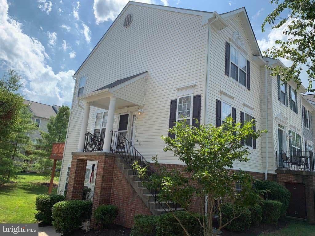
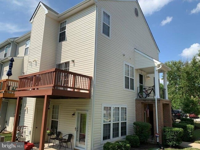
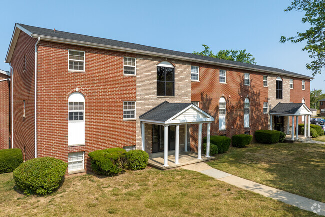
8604 Aspen Grove Ct
Odenton, MD 21113
Today
Favorites
703-831-6806
-
Bedrooms
3
-
Bathrooms
2.5
-
Square Feet
--
-
Available
Available Now
Highlights
- Fitness Center
- Vaulted Ceiling
- Community Pool
- Community Center
- Jogging Path
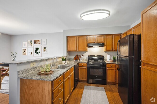
- Stainless Steel Appliances
8604 Aspen Grove Ct

Favorites
About This Home
Available Now
Must see! Available 7/15/2025.
8604 Aspen Grove Ct is a townhome located in Anne Arundel County and the 21113 ZIP Code. This area is served by the Anne Arundel County Public Schools attendance zone.
* Price shown is base rent and may not include non-optional fees and utilities.
Price, availability, fees, and any applicable rent special are subject to change without notice.
* Square footage definitions vary. Displayed square footage is approximate.
Home Details
Home Type
End Unit Townhome
Year Built
Built in 2000
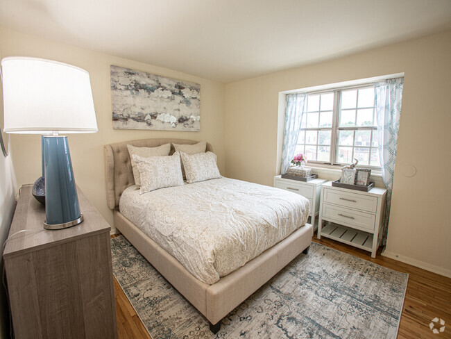
Bedrooms and Bathrooms
En-Suite Primary Bedroom
2.5 Bathrooms
3 Bedrooms
Flooring
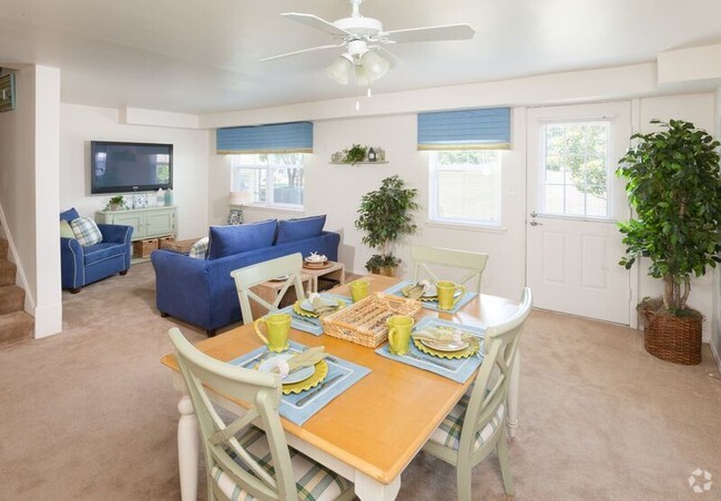
Partially Carpeted
Vinyl
Home Design
Vinyl Siding
Asphalt Roof
Home Security
Storm Windows
Storm Doors
Carbon Monoxide Detectors
Fire and Smoke Detector
Interior Spaces
Vaulted Ceiling
Sliding Doors
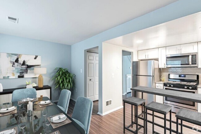
Combination Dining and Living Room
Ceiling Fan
Family Room
1,332 Sq Ft Home
Property has 2 Levels
Sliding Windows
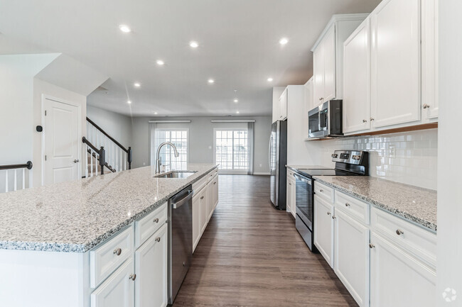
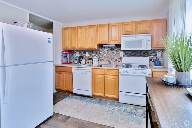
Kitchen
Stainless Steel Appliances
Kitchen Island
Stove
Ice Maker
Built-In Microwave
Dishwasher
Disposal
Laundry
Laundry Room
Laundry on main level
Electric Front Loading Dryer
Washer
Listing and Financial Details
Security Deposit $2,500
12-Month Min and 24-Month Max Lease Term
Available 7/15/25
Assessor Parcel Number 020457190101242
Tenant pays for cable TV, electricity, frozen waterpipe damage, heat, hot water, insurance, light bulbs/filters/fuses/alarm care, pest control, snow removal, all utilities, water
Rent includes common area maintenance, community center, grounds maintenance, hoa/condo fee, HVAC maint, lawn service, parking, recreation facility, sewer, trash removal
No Smoking Allowed
Residential Lease
Lot Details
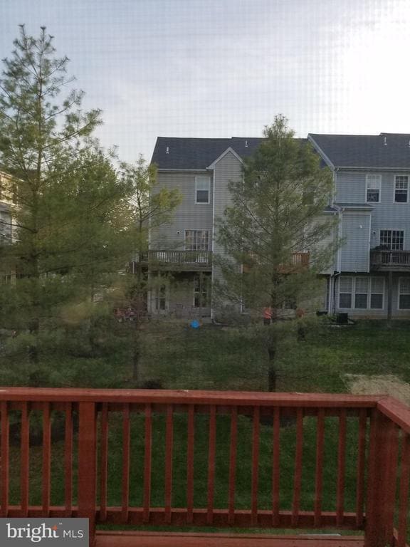
Backs To Open Common Area
Parking
1 Assigned Parking Space
Unassigned Parking
Parking Lot
Free Parking
Parking Space Conveys
Schools
Piney Orchard Elementary School
Arundel Middle School
Arundel High School
Utilities
Programmable Thermostat
Central Heating and Cooling System
Electric Water Heater
Community Details
Amenities
Community Center
Recreation Room
Overview
No Home Owners Association
Woodland Walk Community
Piney Orchard Subdivision
Pet Policy
No Pets Allowed
Recreation
Fitness Center
Community Pool
Jogging Path
Contact
- Listed by Stephanie J Smith | Select Premium Properties, Inc
- Phone Number
- Contact
-
Source
 Bright MLS, Inc.
Copyright © 2025 Bright MLS, Inc.
Location
Get Directions
Amenities
- Dishwasher
Situated in Anne Arundel County, Odenton is centrally located between Annapolis, Washington D.C., and Baltimore. The city is continuously growing in population, largely due to its proximity to Fort George G. Meade military base and the developing Piney Orchard neighborhood.
In Odenton, you’ll discover a lot of great shopping centers like Waugh Chapel Towne Centre. Hikers will enjoy the plethora of trails that reside within the community, including Little Patuxent River Trail, Wild Turkey Way, and Merganser Pond Trail, among others. Midland Park is a large green space just minutes from Bowie State University. This Baltimore suburb contains highly rated public schools, plus access to Interstate 97 and Odenton Station.
Learn more about living in Odenton
Education
| Colleges & Universities | Distance | ||
|---|---|---|---|
| Colleges & Universities | Distance | ||
| Drive: | 28 min | 13.4 mi | |
| Drive: | 30 min | 15.7 mi | |
| Drive: | 30 min | 16.4 mi | |
| Drive: | 36 min | 21.9 mi |
8604 Aspen Grove Ct is within 28 minutes or 13.4 miles from Bowie State University. It is also near Anne Arundel Community College and CCBC Cantonsville.
Schools


Public Elementary School
Grades K-5
966 Students
Attendance Zone
Public Elementary School
Grades PK-5
573 Students
Nearby
Public Middle School
Grades 6-8
1,286 Students
Attendance Zone
Public High School
Grades 9-12
1,617 Students
Attendance Zone
Private Elementary, Middle & High School
Grades PK-12
181 Students
Nearby
School data provided by
 The GreatSchools Rating helps parents compare schools within a state based on a variety of school quality indicators and provides a helpful picture of how effectively each school serves all of its students. Ratings are on a scale of 1 (below average) to 10 (above average) and can include test scores, college readiness, academic progress, advanced courses, equity, discipline and attendance data. We also advise parents to visit schools, consider other information on school performance and programs, and consider family needs as part of the school selection process.
View GreatSchools Rating Methodology
View GreatSchools Rating Methodology
Transportation options available in Odenton include Bwi Business District, located 11.0 miles from 8604 Aspen Grove Ct. 8604 Aspen Grove Ct is near Baltimore/Washington International Thurgood Marshall, located 11.0 miles or 22 minutes away, and Ronald Reagan Washington Ntl, located 33.9 miles or 53 minutes away.
| Transit / Subway | Distance | ||
|---|---|---|---|
| Transit / Subway | Distance | ||
|
|
Drive: | 21 min | 11.0 mi |
|
Bwi Airport
|
Drive: | 23 min | 11.3 mi |
|
|
Drive: | 22 min | 11.4 mi |
|
Cromwell Station/Glen Burnie
|
Drive: | 21 min | 11.6 mi |
|
Ferndale
|
Drive: | 22 min | 11.9 mi |
| Commuter Rail | Distance | ||
|---|---|---|---|
| Commuter Rail | Distance | ||
|
|
Drive: | 7 min | 2.8 mi |
|
|
Drive: | 20 min | 9.2 mi |
|
|
Drive: | 19 min | 10.6 mi |
|
|
Drive: | 23 min | 11.4 mi |
|
Bowie State Marc Nb
|
Drive: | 28 min | 13.5 mi |
| Airports | Distance | ||
|---|---|---|---|
| Airports | Distance | ||
|
Baltimore/Washington International Thurgood Marshall
|
Drive: | 22 min | 11.0 mi |
|
Ronald Reagan Washington Ntl
|
Drive: | 53 min | 33.9 mi |
Time and distance from 8604 Aspen Grove Ct.
| Shopping Centers | Distance | ||
|---|---|---|---|
| Shopping Centers | Distance | ||
| Walk: | 11 min | 0.6 mi | |
| Drive: | 6 min | 2.5 mi | |
| Drive: | 7 min | 2.8 mi |
8604 Aspen Grove Ct has 3 shopping centers within 2.8 miles, which is about a 7-minute walk. The miles and minutes will be for the farthest away property.
| Parks and Recreation | Distance | ||
|---|---|---|---|
| Parks and Recreation | Distance | ||
|
Patuxent Research Refuge - North Tract
|
Drive: | 18 min | 8.4 mi |
|
Kinder Farm Park
|
Drive: | 25 min | 12.0 mi |
|
Patuxent Research Refuge - South Tract
|
Drive: | 32 min | 16.5 mi |
|
Howard Owens Science Center
|
Drive: | 32 min | 17.4 mi |
|
NASA Goddard Space Flight Center
|
Drive: | 32 min | 17.8 mi |
8604 Aspen Grove Ct has 5 parks within 17.8 miles, including Patuxent Research Refuge - North Tract, Kinder Farm Park, and Patuxent Research Refuge - South Tract.
| Hospitals | Distance | ||
|---|---|---|---|
| Hospitals | Distance | ||
| Drive: | 21 min | 11.6 mi | |
| Drive: | 28 min | 14.3 mi | |
| Drive: | 34 min | 19.6 mi |
8604 Aspen Grove Ct has 3 hospitals within 19.6 miles, the nearest is University of Maryland Baltimore Washington Medical Center which is 11.6 miles away and a 21 minute drive.
| Military Bases | Distance | ||
|---|---|---|---|
| Military Bases | Distance | ||
| Drive: | 14 min | 6.0 mi |
8604 Aspen Grove Ct is 6.0 miles and a 14 minute drive from Fort George Meade.
You May Also Like
Similar Rentals Nearby


What Are Walk Score®, Transit Score®, and Bike Score® Ratings?
Walk Score® measures the walkability of any address. Transit Score® measures access to public transit. Bike Score® measures the bikeability of any address.
What is a Sound Score Rating?
A Sound Score Rating aggregates noise caused by vehicle traffic, airplane traffic and local sources

8604 Aspen Grove Ct
Odenton, MD 21113