


$4,650 / Month
833 San Petronio Ave
Sunnyvale, CA 94085
Today
Favorites
-
Bedrooms
4
-
Bathrooms
2
-
Square Feet
1,350 sq ft
833 San Petronio Ave

Favorites
About This Home
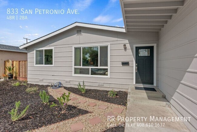
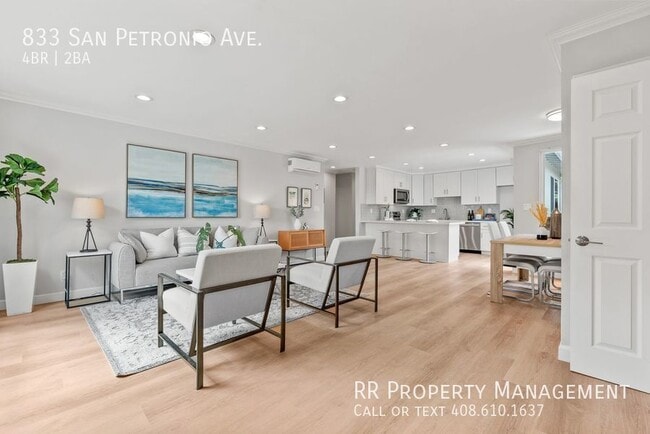
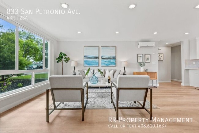
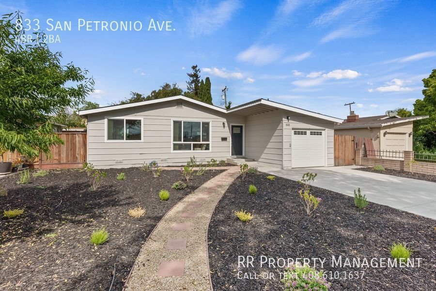
---- SCHEDULE A SHOWING ONLINE AT: ---- Come and see this beautifully remodeled single-family home in a convenient location of North Sunnyvale! Open floor plan with a sun-filled great room and luxury vinyl laminate throughout. Remodeled kitchen with white shaker cabinets, quartz counters, large breakfast bar, and stainless steel appliances. Updated bathrooms and dedicated heating/cooling system in each room. Sliding door from kitchen leads to spacious backyard patio. Low maintenance landscaping! (monthly maintenance incl. in rent) One-car attached garage. A commuter's dream! Close to 101/237/Lawrence Expwy. Downtown Sunnyvale and Mercado 20 nearby! Short commute to Google, Apple, Cisco, and many other high tech offices! No pets, no smoking. 1 year lease term. $25 non-refundable application fee, per adult.
833 San Petronio Ave is a house located in Santa Clara County and the 94085 ZIP Code. This area is served by the Sunnyvale attendance zone.
* Price shown is base rent and may not include non-optional fees and utilities.
Price, availability, fees, and any applicable rent special are subject to change without notice.
* Square footage definitions vary. Displayed square footage is approximate.
House Features
- Washer/Dryer Hookup
- Air Conditioning
Fees and Policies
The fees below are based on community-supplied data and may exclude additional fees and utilities.
- Parking
-
Garage--
-
Other--
Location
Get Directions
Amenities
- Washer/Dryer Hookup
- Air Conditioning
Sunnyvale’s San Miguel neighborhood is a residential community located near the intersection of the Bayshore Freeway and Lawrence Expressway. San Miguel offers residents a variety of options to try international cuisine with presence of the Taj Mahal Fresh Market, Pho Vy Vietnamese, Clarita’s Filipino Cuisine, Barn Thai, Tia Juana Mexican Grill, and Tres Potrillos Taqueria.
Neighboring parks such as Fair Oaks Park, Lakewood Park, Seven Seas Park, and Columbia Park provide endless opportunities for outdoor recreation. Major attractions like Levi’s Stadium, Intel Museum, and California’s Great America are all within a short drive from San Miguel too.
Convenient to multiple bus routes in addition to the Bayshore Freeway and Lawrence Expressway, commuting from San Miguel is simple. Mineta San Jose International Airport is just minutes down the Bayshore Freeway from San Miguel, making for easy travels.
Learn more about living in San Miguel
Education
| Colleges & Universities | Distance | ||
|---|---|---|---|
| Colleges & Universities | Distance | ||
| Drive: | 11 min | 6.1 mi | |
| Drive: | 12 min | 6.6 mi | |
| Drive: | 13 min | 7.3 mi | |
| Drive: | 16 min | 10.0 mi |
833 San Petronio Ave is within 11 minutes or 6.1 miles from Palmer College of Chiropractic West Campus. It is also near Santa Clara University and Foothill College, Middlefield.
Schools


Public Elementary School
Grades K-5
367 Students
Nearby
Public Elementary School
Grades K-5
385 Students
Attendance Zone
Public Middle School
Grades 6-8
587 Students
Attendance Zone
Public High School
Grades 9-12
2,171 Students
Attendance Zone
Private Elementary & Middle School
Grades PK-8
236 Students
Nearby
Private Elementary School
Grades PK-6
810 Students
Nearby
Private Middle & High School
Grades 6-12
937 Students
Nearby
School data provided by
 The GreatSchools Rating helps parents compare schools within a state based on a variety of school quality indicators and provides a helpful picture of how effectively each school serves all of its students. Ratings are on a scale of 1 (below average) to 10 (above average) and can include test scores, college readiness, academic progress, advanced courses, equity, discipline and attendance data. We also advise parents to visit schools, consider other information on school performance and programs, and consider family needs as part of the school selection process.
View GreatSchools Rating Methodology
Data provided by GreatSchools.org © 2025. All rights reserved.
View GreatSchools Rating Methodology
Data provided by GreatSchools.org © 2025. All rights reserved.
Transportation options available in Sunnyvale include Fair Oaks Station, located 1.4 miles from 833 San Petronio Ave. 833 San Petronio Ave is near Norman Y Mineta San Jose International, located 6.2 miles or 10 minutes away, and Metro Oakland International, located 36.2 miles or 47 minutes away.
| Transit / Subway | Distance | ||
|---|---|---|---|
| Transit / Subway | Distance | ||
|
|
Drive: | 3 min | 1.4 mi |
|
|
Drive: | 4 min | 1.9 mi |
| Drive: | 4 min | 2.0 mi | |
| Drive: | 4 min | 2.2 mi | |
| Drive: | 5 min | 2.5 mi |
| Commuter Rail | Distance | ||
|---|---|---|---|
| Commuter Rail | Distance | ||
| Drive: | 5 min | 2.1 mi | |
| Drive: | 7 min | 2.5 mi | |
| Drive: | 9 min | 4.9 mi | |
| Drive: | 10 min | 5.4 mi | |
| Drive: | 10 min | 5.4 mi |
| Airports | Distance | ||
|---|---|---|---|
| Airports | Distance | ||
|
Norman Y Mineta San Jose International
|
Drive: | 10 min | 6.2 mi |
|
Metro Oakland International
|
Drive: | 47 min | 36.2 mi |
Time and distance from 833 San Petronio Ave.
| Shopping Centers | Distance | ||
|---|---|---|---|
| Shopping Centers | Distance | ||
| Walk: | 7 min | 0.4 mi | |
| Drive: | 3 min | 1.1 mi | |
| Drive: | 3 min | 1.2 mi |
833 San Petronio Ave has 3 shopping centers within 1.2 miles, which is about a 3-minute walk. The miles and minutes will be for the farthest away property.
| Parks and Recreation | Distance | ||
|---|---|---|---|
| Parks and Recreation | Distance | ||
|
Sunnyvale Baylands Park
|
Drive: | 8 min | 3.1 mi |
|
Ulistac Natural Area
|
Drive: | 9 min | 4.5 mi |
|
Live Oak Park - Santa Clara
|
Drive: | 8 min | 5.2 mi |
|
Alviso Marina County Park
|
Drive: | 10 min | 5.8 mi |
|
Stevens Creek Shoreline Nature Study Area
|
Drive: | 12 min | 6.4 mi |
833 San Petronio Ave has 5 parks within 6.4 miles, including Sunnyvale Baylands Park, Ulistac Natural Area, and Live Oak Park - Santa Clara.
| Hospitals | Distance | ||
|---|---|---|---|
| Hospitals | Distance | ||
| Drive: | 8 min | 4.5 mi | |
| Drive: | 8 min | 4.6 mi | |
| Drive: | 10 min | 5.9 mi |
833 San Petronio Ave has 3 hospitals within 5.9 miles, the nearest is Kaiser Foundation Hospital - Santa Clara which is 4.5 miles away and a 8 minute drive.
| Military Bases | Distance | ||
|---|---|---|---|
| Military Bases | Distance | ||
| Drive: | 10 min | 5.2 mi |
833 San Petronio Ave is 5.2 miles and a 10 minute drive from Ames Research Center.
You May Also Like
Similar Rentals Nearby


What Are Walk Score®, Transit Score®, and Bike Score® Ratings?
Walk Score® measures the walkability of any address. Transit Score® measures access to public transit. Bike Score® measures the bikeability of any address.
What is a Sound Score Rating?
A Sound Score Rating aggregates noise caused by vehicle traffic, airplane traffic and local sources
833 San Petronio Ave
Sunnyvale, CA 94085