$2,950
Total Monthly Price
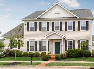
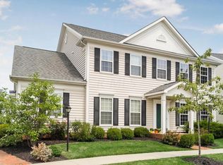
8247 Parsons Pass
New Albany, OH 43054
2 Weeks Ago
|
Edit
Favorites
8247 Parsons Pass

Favorites
Check Back Soon for Upcoming Availability
| Beds | Baths | Average SF |
|---|---|---|
| 3 Bedrooms 3 Bedrooms 3 Br | 2.5 Baths 2.5 Baths 2.5 Ba | 1,800 SF |
Fees and Policies
The fees listed below are community-provided and may exclude utilities or add-ons. All payments are made directly to the property and are non-refundable unless otherwise specified.
- Parking
-
Garage--
Details
Lease Options
-
12
About This Property
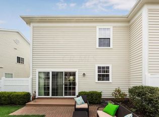
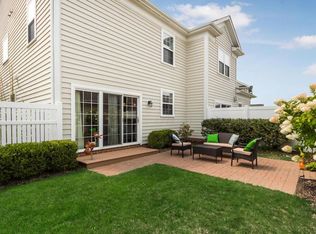
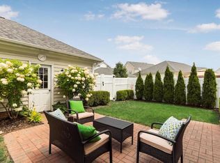
8247 Parsons Pass, New Albany, OH 43054 3 beds 3 baths 1,804 sqft The elegance and features in this two-story Town home are remarkable. The entry level has Cherry hardwood floors, gorgeous lighting and a formal dining and living area. French doors lead to the chef's kitchen with marble island, stainless steel appliances, farmhouse sink and granite counter tops. The second level features 3 large bedrooms, and 2 full baths with premium fixtures and lighting. The master features a walk-in closet and full bath with marble flooring. Two additional bedrooms also with walk-in closets. First floor also features a half-bath and laundry complete with washer and dryer. Detached two car garage borders a private outdoor entertaining area with patio and professional landscaping. in the back yard and steps from the beautiful community park! The Windsor neighborhood is within walking distance of the New Albany Schools, and is Ideally located within minutes of Easton and Columbus. Pets by pre-approval only.
8247 Parsons Pass is a townhome located in Franklin County and the 43054 ZIP Code.
Townhome Features
Washer/Dryer
Air Conditioning
Dishwasher
Hardwood Floors
- Washer/Dryer
- Air Conditioning
- Smoke Free
- Fireplace
- Dishwasher
- Granite Countertops
- Stainless Steel Appliances
- Kitchen
- Hardwood Floors
- Walk-In Closets
- Patio
- Yard
8247 Parsons Pass,
New Albany,
OH
43054
Around 15 miles outside of the center of Columbus, Ohio, Outer Northeast Columbus includes the neighborhoods of Westerville and Huber Ridge. The area has an abundant selection of parks, lakes and golf courses, attracting people who seek outdoor recreation. Both Interstate 71 and Highway 270 border Outer Northeast Columbus, making travel to downtown and other areas of the city simple and convenient.
Many families flock to outer northeast Columbus for its recreation and amenities. Westerville includes plenty of dining and shopping options, along with excellent residential neighborhoods and schools. Residents find refuge from busier areas of the city while enjoying the benefits of easy commutes, along with plenty of opportunities for fun and entertainment.
Learn more about living in Northeast Columbus
Amenities
- Washer/Dryer
- Air Conditioning
- Smoke Free
- Fireplace
- Dishwasher
- Granite Countertops
- Stainless Steel Appliances
- Kitchen
- Hardwood Floors
- Walk-In Closets
- Patio
- Yard
Education
| Colleges & Universities | Distance | ||
|---|---|---|---|
| Colleges & Universities | Distance | ||
| Drive: | 15 min | 10.4 mi | |
| Drive: | 17 min | 11.9 mi | |
| Drive: | 23 min | 14.1 mi | |
| Drive: | 21 min | 14.6 mi |
8247 Parsons Pass is within 15 minutes or 10.4 miles from Otterbein College. It is also near Ohio Dominican University and Capital University.
Walkability Near 8247 Parsons Pass New Albany, OH 43054
Getting Around
 What do Walkability, Transit, Drivability, and Bikeability mean?
Walkability measures the walking distance to day-to-day needs.
Transit measures access to public transportation.
Drivability measures congestion, parking availability, and access to major roads.
Bikeability measures the suitability for cycling.
How It Works
What do Walkability, Transit, Drivability, and Bikeability mean?
Walkability measures the walking distance to day-to-day needs.
Transit measures access to public transportation.
Drivability measures congestion, parking availability, and access to major roads.
Bikeability measures the suitability for cycling.
How It Works
Somewhat Walkable
Walkability
30
/ 100
Minimal Public Transit
Transit
0
/ 100
Exceptionally Drivable
Drivability
100
/ 100
Fairly Bikeable
Bikeability
40
/ 100
Scores provided by
-
Soundscore™
-
/ 100
Traffic
-Airport
-Businesses
-Scores provided by
HowLoud What is a Sound Score Rating? A Sound Score Rating aggregates noise caused by vehicle traffic, airplane traffic and local sources. How It WorksYou May Also Like
Similar Rentals Nearby


What Are Walk Score®, Transit Score®, and Bike Score® Ratings?
Walk Score® measures the walkability of any address. Transit Score® measures access to public transit. Bike Score® measures the bikeability of any address.
What is a Sound Score Rating?
A Sound Score Rating aggregates noise caused by vehicle traffic, airplane traffic and local sources.

8247 Parsons Pass
New Albany, OH 43054