$2,300
/ Month
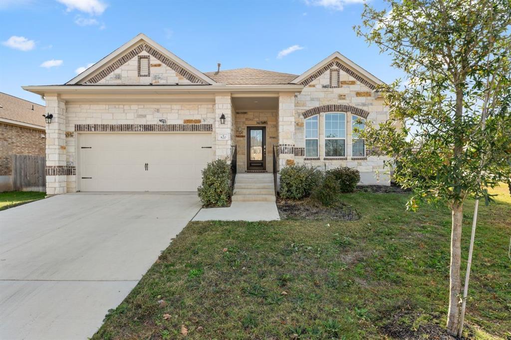
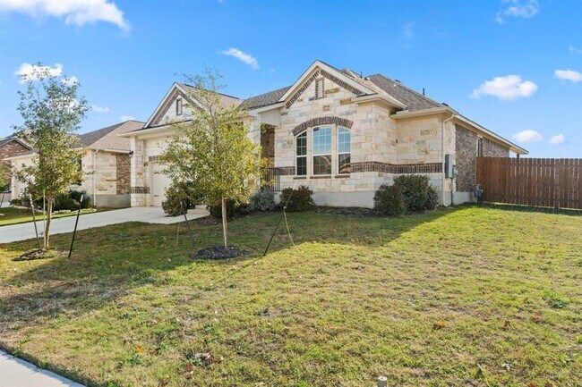
820 Paper Daisy Path
Leander, TX 78641
2 Weeks Ago
|
Edit
Favorites
820 Paper Daisy Path

Favorites
Check Back Soon for Upcoming Availability
| Beds | Baths | Average SF |
|---|---|---|
| 3 Bedrooms 3 Bedrooms 3 Br | 2 Baths 2 Baths 2 Ba | 1,857 SF |
Fees and Policies
The fees below are based on community-supplied data and may exclude additional fees and utilities.
About This Property
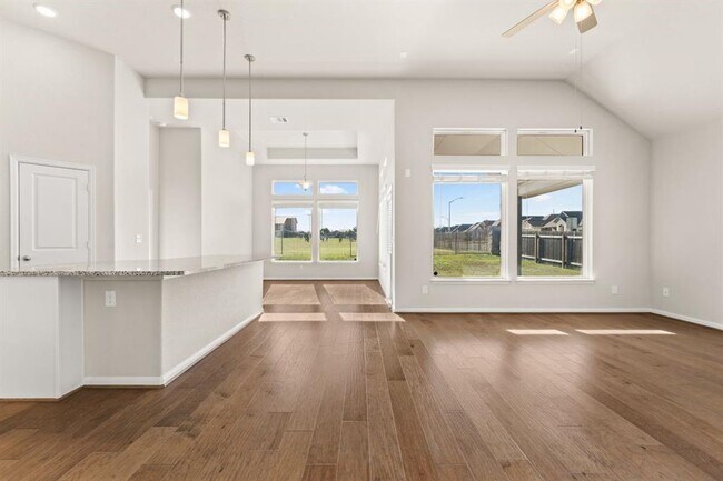
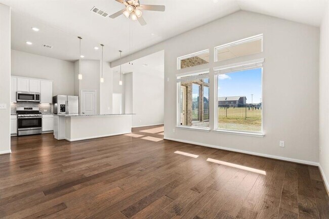
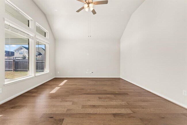
6-month lease is preferred. Move-in allowance. Castlerock communities built home. Whitman plan. Oak Creek subdivision is located off 183 and very close to the Metro Rail! The Kitchen is filled with natural light, glass subway tiles, granite countertops, under-counter lighting, a walk-in pantry, and one of the largest islands you have ever seen! Engineered wood floors throughout all public areas of the house. Carpet in bedrooms and tile in both bathrooms. 2 car garage with tall ceilings and garage door opener. Large owner's suite & bath with double vanity, large walk-in shower, soaking tub, and extra-large closet! Stainless refrigerator. Washer/Dryer. Pets must be approved by the owner. Agent is related to the owners.
820 Paper Daisy Path is a house located in Williamson County and the 78641 ZIP Code. This area is served by the Leander Independent attendance zone.
House Features
Dishwasher
Hardwood Floors
Microwave
Disposal
- Dishwasher
- Disposal
- Microwave
- Hardwood Floors
- Carpet
- Tile Floors
Location
Get Directions
Located 22 miles northwest of Austin, Leander combines Hill Country scenery with suburban living. The city features established neighborhoods like Mason Creek, Travisso, and Crystal Falls, each offering their own mix of housing options from single-family homes to townhouses.
Parks and outdoor spaces define Leander's landscape, including Benbrook Ranch Park's skating facilities and Robin Bledsoe Park's pool and sports courts. The city's natural limestone formations and rolling hills provide scenic backdrops for hiking and biking trails throughout the area.
Archaeological significance adds to Leander's character, as the site of the "Leanderthal Lady" discovery represents one of North America's oldest burial sites. The MetroRail Red Line's Leander Station connects residents to downtown Austin, while major thoroughfares provide access to the region's employment centers.
Learn more about living in Leander
Amenities
- Dishwasher
- Disposal
- Microwave
- Hardwood Floors
- Carpet
- Tile Floors
Education
| Colleges & Universities | Distance | ||
|---|---|---|---|
| Colleges & Universities | Distance | ||
| Drive: | 16 min | 10.9 mi | |
| Drive: | 28 min | 14.9 mi | |
| Drive: | 25 min | 16.4 mi | |
| Drive: | 28 min | 16.8 mi |
820 Paper Daisy Path is within 16 minutes or 10.9 miles from Austin C.C., Cypress Creek. It is also near Concordia University Texas and Southwestern University.
Schools


Public Elementary School
Grades PK-5
811 Students
Attendance Zone
Public Middle School
Grades 6-8
802 Students
Nearby
Public High School
Grades 9-12
2,063 Students
Attendance Zone
Private Elementary, Middle & High School
Grades PK-12
Nearby
School data provided by
 The GreatSchools Rating helps parents compare schools within a state based on a variety of school quality indicators and provides a helpful picture of how effectively each school serves all of its students. Ratings are on a scale of 1 (below average) to 10 (above average) and can include test scores, college readiness, academic progress, advanced courses, equity, discipline and attendance data. We also advise parents to visit schools, consider other information on school performance and programs, and consider family needs as part of the school selection process.
View GreatSchools Rating Methodology
Data provided by GreatSchools.org © 2025. All rights reserved.
View GreatSchools Rating Methodology
Data provided by GreatSchools.org © 2025. All rights reserved.
Transportation options available in Leander include Leander Station, located 1.5 miles from 820 Paper Daisy Path. 820 Paper Daisy Path is near Austin-Bergstrom International, located 38.7 miles or 52 minutes away, and Robert Gray AAF, located 39.8 miles or 63 minutes away.
| Transit / Subway | Distance | ||
|---|---|---|---|
| Transit / Subway | Distance | ||
| Drive: | 4 min | 1.5 mi | |
| Drive: | 18 min | 11.6 mi |
| Commuter Rail | Distance | ||
|---|---|---|---|
| Commuter Rail | Distance | ||
|
|
Drive: | 36 min | 27.6 mi |
|
|
Drive: | 48 min | 38.9 mi |
| Airports | Distance | ||
|---|---|---|---|
| Airports | Distance | ||
|
Austin-Bergstrom International
|
Drive: | 52 min | 38.7 mi |
|
Robert Gray AAF
|
Drive: | 63 min | 39.8 mi |
Time and distance from 820 Paper Daisy Path.
| Shopping Centers | Distance | ||
|---|---|---|---|
| Shopping Centers | Distance | ||
| Walk: | 13 min | 0.7 mi | |
| Walk: | 16 min | 0.9 mi | |
| Walk: | 17 min | 0.9 mi |
820 Paper Daisy Path has 3 shopping centers within 0.9 mile, which is about a 17-minute walk. The miles and minutes will be for the farthest away property.
| Parks and Recreation | Distance | ||
|---|---|---|---|
| Parks and Recreation | Distance | ||
|
Austin Steam Train
|
Drive: | 12 min | 6.6 mi |
|
Garey Park
|
Drive: | 19 min | 7.1 mi |
820 Paper Daisy Path has 2 parks within 7.1 miles, including Austin Steam Train, and Garey Park.
| Hospitals | Distance | ||
|---|---|---|---|
| Hospitals | Distance | ||
| Drive: | 13 min | 7.4 mi |
820 Paper Daisy Path is 7.4 miles and a 13 minute drive from Cedar Park Regional Medical Center.
| Military Bases | Distance | ||
|---|---|---|---|
| Military Bases | Distance | ||
| Drive: | 68 min | 51.0 mi | |
| Drive: | 137 min | 108.7 mi |
820 Paper Daisy Path is 51.0 miles from Fort Hood, and is convenient to other military bases, including Camp Bullis Military Training Reservation.
You May Also Like
Similar Rentals Nearby
-
-
-
-
1 / 9

-
-
-
-
1 / 10

-
-


What Are Walk Score®, Transit Score®, and Bike Score® Ratings?
Walk Score® measures the walkability of any address. Transit Score® measures access to public transit. Bike Score® measures the bikeability of any address.
What is a Sound Score Rating?
A Sound Score Rating aggregates noise caused by vehicle traffic, airplane traffic and local sources

820 Paper Daisy Path
Leander, TX 78641