
$3,650 / Month
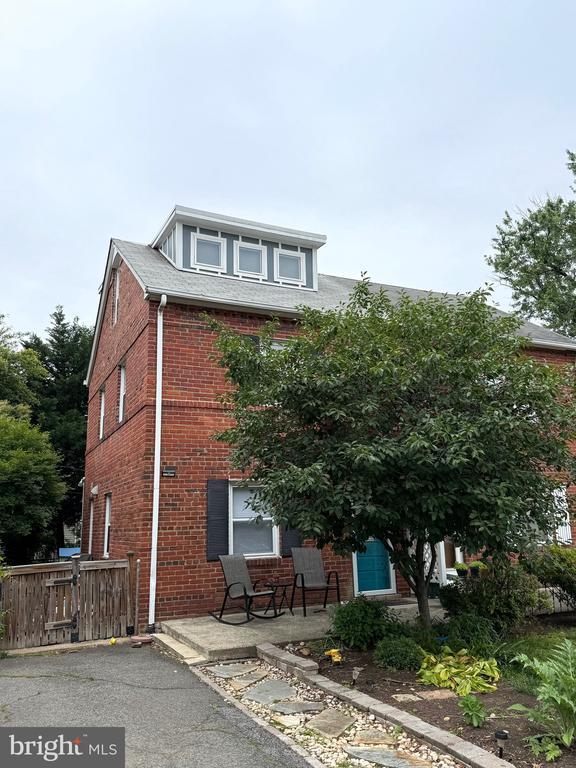
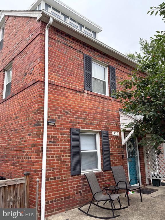
819 S Irving St
Arlington, VA 22204
Today
Favorites
334-669-8208
-
Bedrooms
3
-
Bathrooms
2.5
-
Square Feet
--
-
Available
Available Now
Highlights
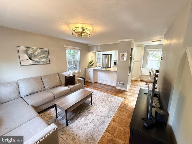
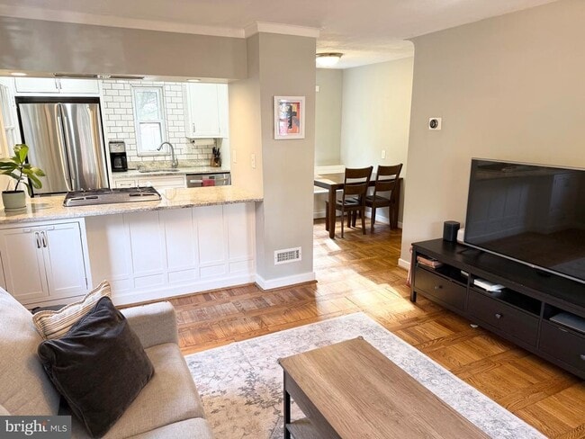
- Open Floorplan
- Colonial Architecture
- Wood Flooring
- Upgraded Countertops
- Stainless Steel Appliances
- Built-In Features
819 S Irving St

Favorites
About This Home
Available Now
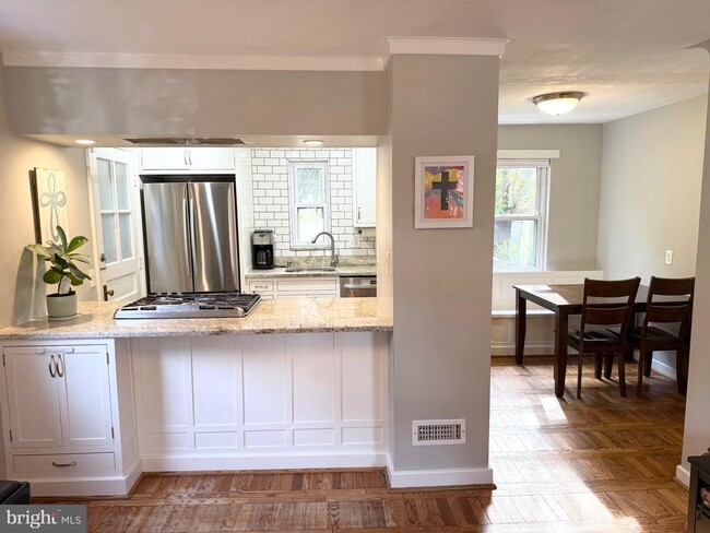
Renovated 3-bedroom, 2.5-bath duplex in Westmont/Arlington Heights. The open layout includes a modern kitchen with granite counters, stainless appliances, and a breakfast bar that connects to the living and dining areas. The dining space includes a built-in bench that’s perfect for hosting or just hanging out. Upstairs, the primary suite has a private bath with double sinks, a walk-in closet with built-ins and convenient access to the washer/dryer. The finished basement offers a rec room with a Murphy bed (mattress not included), half bath, and walk-up access to the backyard. Easy access to DC, Clarendon, Ballston, Shirlington, Old Town, and Columbia Pike’s shops and restaurants. No pets. Tenant pays all utilities and lawn care.
819 S Irving St is a house located in Arlington County and the 22204 ZIP Code. This area is served by the Arlington County Public Schools attendance zone.
* Price shown is base rent and may not include non-optional fees and utilities.
Price, availability, fees, and any applicable rent special are subject to change without notice.
* Square footage definitions vary. Displayed square footage is approximate.
Home Details
Home Type
Semi-Detached or Twin Home
Year Built
Built in 1939
Bedrooms and Bathrooms
Walk-In Closet
En-Suite Primary Bedroom
En-Suite Bathroom
2.5 Bathrooms
3 Bedrooms
Flooring
Wood
Carpet
Home Design
Colonial Architecture
Architectural Shingle Roof
Brick Exterior Construction
Interior Spaces
Open Floorplan
Built-In Features
Living Room
Recessed Lighting
Dining Room
Ceiling Fan
Family Room
1,393 Sq Ft Home
Property has 4 Levels
Kitchen
Upgraded Countertops
Stainless Steel Appliances
Gas Oven or Range
Dishwasher
Disposal
Laundry
Laundry Room
Laundry on upper level
Front Loading Dryer
Front Loading Washer
Listing and Financial Details
Security Deposit $3,650
12-Month Min and 36-Month Max Lease Term
Available 7/15/25
$50 Application Fee
Assessor Parcel Number 25-011-050
No Smoking Allowed
Residential Lease
Lot Details
2,335 Sq Ft Lot
Outdoor Features
Patio
Parking
Driveway
Schools
Wakefield High School
Utilities
Forced Air Zoned Heating and Cooling System
Heat Pump System
Natural Gas Water Heater
Community Details
Overview
No Home Owners Association
Property Manager
Westmont Subdivision
Pet Policy
No Pets Allowed
Contact
- Listed by Lana Beard | KW Metro Center
- Phone Number
- Contact
-
Source
 Bright MLS, Inc.
Copyright © 2025 Bright MLS, Inc.
Location
Get Directions
Amenities
- Dishwasher
- Basement
With brick colonials along tree-lined streets, Arlington Heights is a popular historic neighborhood just south of Downtown Arlington. The picturesque neighborhood is listed on the National Register of Historic Places and contains more than 737 historic structures and sites.
Arlington Heights extends south from Arlington Boulevard to Columbia Pike. It is just west of Arlington National Cemetery between S. Walter Reed Drive and South Glebe Road. Located just over one mile from downtown, apartments in Arlington Heights offer easy access to Ballston Common Mall, the Pentagon, and Joint Base Myer-Henderson Hall.
Learn more about living in Arlington Heights
Education
| Colleges & Universities | Distance | ||
|---|---|---|---|
| Colleges & Universities | Distance | ||
| Drive: | 7 min | 1.9 mi | |
| Drive: | 7 min | 2.8 mi | |
| Drive: | 11 min | 4.5 mi | |
| Drive: | 9 min | 4.7 mi |
819 S Irving St is within 7 minutes or 1.9 miles from George Mason Univ., Arlington. It is also near NOVA, Alexandira Campus and Georgetown University.
Schools


Public Elementary School
Grades PK-5
614 Students
Attendance Zone
Public Middle School
Grades 6-8
1,053 Students
Attendance Zone
Public High School
Grades 9-12
2,766 Students
Attendance Zone
Private Elementary & Middle School
Grades PK-8
117 Students
Nearby
Private Elementary, Middle & High School
Grades PK-12
Nearby
School data provided by
 The GreatSchools Rating helps parents compare schools within a state based on a variety of school quality indicators and provides a helpful picture of how effectively each school serves all of its students. Ratings are on a scale of 1 (below average) to 10 (above average) and can include test scores, college readiness, academic progress, advanced courses, equity, discipline and attendance data. We also advise parents to visit schools, consider other information on school performance and programs, and consider family needs as part of the school selection process.
View GreatSchools Rating Methodology
Data provided by GreatSchools.org © 2025. All rights reserved.
View GreatSchools Rating Methodology
Data provided by GreatSchools.org © 2025. All rights reserved.
Transportation options available in Arlington include Clarendon, Orange/Silver Line Track 1 Platform, located 2.0 miles from 819 S Irving St. 819 S Irving St is near Ronald Reagan Washington Ntl, located 4.7 miles or 11 minutes away, and Washington Dulles International, located 23.6 miles or 40 minutes away.
| Transit / Subway | Distance | ||
|---|---|---|---|
| Transit / Subway | Distance | ||
| Drive: | 6 min | 2.0 mi | |
| Drive: | 5 min | 2.0 mi | |
| Drive: | 6 min | 2.0 mi | |
| Drive: | 5 min | 2.3 mi | |
| Drive: | 5 min | 2.4 mi |
| Commuter Rail | Distance | ||
|---|---|---|---|
| Commuter Rail | Distance | ||
|
|
Drive: | 7 min | 2.9 mi |
|
|
Drive: | 10 min | 4.8 mi |
|
|
Drive: | 10 min | 4.8 mi |
|
|
Drive: | 13 min | 5.4 mi |
|
|
Drive: | 13 min | 5.4 mi |
| Airports | Distance | ||
|---|---|---|---|
| Airports | Distance | ||
|
Ronald Reagan Washington Ntl
|
Drive: | 11 min | 4.7 mi |
|
Washington Dulles International
|
Drive: | 40 min | 23.6 mi |
Time and distance from 819 S Irving St.
| Shopping Centers | Distance | ||
|---|---|---|---|
| Shopping Centers | Distance | ||
| Walk: | 7 min | 0.4 mi | |
| Walk: | 9 min | 0.5 mi | |
| Walk: | 10 min | 0.5 mi |
819 S Irving St has 3 shopping centers within 0.5 mile, which is about a 10-minute walk. The miles and minutes will be for the farthest away property.
| Parks and Recreation | Distance | ||
|---|---|---|---|
| Parks and Recreation | Distance | ||
|
Douglas Park
|
Drive: | 4 min | 1.2 mi |
|
Shirlington Park
|
Drive: | 5 min | 1.8 mi |
|
Lubber Run Park
|
Drive: | 5 min | 2.0 mi |
|
Allie S. Freed Park
|
Drive: | 6 min | 2.3 mi |
|
Glencarlyn Park
|
Drive: | 8 min | 3.1 mi |
819 S Irving St has 5 parks within 3.1 miles, including Douglas Park, Shirlington Park, and Allie S. Freed Park.
| Hospitals | Distance | ||
|---|---|---|---|
| Hospitals | Distance | ||
| Drive: | 7 min | 2.6 mi | |
| Drive: | 8 min | 3.0 mi | |
| Drive: | 9 min | 3.7 mi |
819 S Irving St has 3 hospitals within 3.7 miles, the nearest is Capital Hospice which is 2.6 miles away and a 7 minute drive.
| Military Bases | Distance | ||
|---|---|---|---|
| Military Bases | Distance | ||
| Drive: | 4 min | 1.6 mi |
819 S Irving St is 1.6 miles and a 4 minute drive from Fort Myer.
You May Also Like
Similar Rentals Nearby


What Are Walk Score®, Transit Score®, and Bike Score® Ratings?
Walk Score® measures the walkability of any address. Transit Score® measures access to public transit. Bike Score® measures the bikeability of any address.
What is a Sound Score Rating?
A Sound Score Rating aggregates noise caused by vehicle traffic, airplane traffic and local sources

819 S Irving St
Arlington, VA 22204