
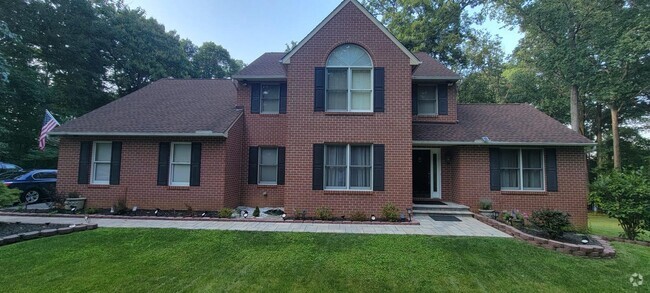
$2,600 / Month
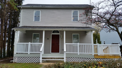
7903 Brookhaven Rd
Milford Mill, MD 21244
Today
Favorites
410-963-3191
-
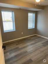
Bedrooms
3
-
Bathrooms
2.5
-
Square Feet
1,738 sq ft
-
Available
Available May 23
7903 Brookhaven Rd

Favorites
Milford Mill is a neighborhood stretching from Interstate 695 to Ridge Road, about 15 miles northwest of Baltimore. While the western section of town is made up of wooded areas and a sprawling golf course, the eastern section of town features tree-lined streets and residential areas. Renters will find moderately priced apartments, townhomes, and two-story homes available for rent. Modern amenities are conveniently located along Liberty Road within town. Just outside of the neighborhood, natural areas around the Patapsco River provide residents with outdoor recreation. Additional shopping can be found a few minutes from town off the interstate at Security Square Shopping Mall.
Learn more about living in Milford Mill
Education
| Colleges & Universities | Distance | ||
|---|---|---|---|
| Colleges & Universities | Distance | ||
| Drive: | 17 min | 6.4 mi | |
| Drive: | 14 min | 7.9 mi | |
| Drive: | 16 min | 8.1 mi | |
| Drive: | 15 min | 8.1 mi |
7903 Brookhaven Rd is within 17 minutes or 6.4 miles from Coppin State University. It is also near Stevenson Univ., Greenspring and Stevenson Univ., Owings Mills.
Schools


Public Elementary School
Grades PK-5
450 Students
Attendance Zone
Public Middle School
Grades 6-8
633 Students
Attendance Zone
Public High School
Grades 9-12
1,324 Students
Attendance Zone
Private Elementary School
Grades PK-5
36 Students
Nearby
Private Elementary, Middle & High School
Grades PK-12
188 Students
Nearby
Private Middle & High School
Grades 7-12
77 Students
Nearby
School data provided by
 The GreatSchools Rating helps parents compare schools within a state based on a variety of school quality indicators and provides a helpful picture of how effectively each school serves all of its students. Ratings are on a scale of 1 (below average) to 10 (above average) and can include test scores, college readiness, academic progress, advanced courses, equity, discipline and attendance data. We also advise parents to visit schools, consider other information on school performance and programs, and consider family needs as part of the school selection process.
View GreatSchools Rating Methodology
View GreatSchools Rating Methodology
Transportation options available in Milford Mill include Old Court, located 1.8 miles from 7903 Brookhaven Rd. 7903 Brookhaven Rd is near Baltimore/Washington International Thurgood Marshall, located 14.1 miles or 23 minutes away.
| Transit / Subway | Distance | ||
|---|---|---|---|
| Transit / Subway | Distance | ||
| Drive: | 5 min | 1.8 mi | |
| Drive: | 8 min | 2.8 mi | |
| Drive: | 9 min | 3.5 mi | |
| Drive: | 10 min | 4.3 mi | |
| Drive: | 8 min | 5.7 mi |
| Commuter Rail | Distance | ||
|---|---|---|---|
| Commuter Rail | Distance | ||
|
|
Drive: | 22 min | 8.4 mi |
|
|
Drive: | 15 min | 9.6 mi |
|
|
Drive: | 19 min | 9.8 mi |
|
|
Drive: | 18 min | 11.3 mi |
|
|
Drive: | 22 min | 13.8 mi |
| Airports | Distance | ||
|---|---|---|---|
| Airports | Distance | ||
|
Baltimore/Washington International Thurgood Marshall
|
Drive: | 23 min | 14.1 mi |
Time and distance from 7903 Brookhaven Rd.
| Shopping Centers | Distance | ||
|---|---|---|---|
| Shopping Centers | Distance | ||
| Walk: | 11 min | 0.6 mi | |
| Walk: | 13 min | 0.7 mi | |
| Walk: | 14 min | 0.7 mi |
7903 Brookhaven Rd has 3 shopping centers within 0.7 mile, which is about a 14-minute walk. The miles and minutes will be for the farthest away property.
| Parks and Recreation | Distance | ||
|---|---|---|---|
| Parks and Recreation | Distance | ||
|
Carrie Murray Nature Center
|
Drive: | 12 min | 4.9 mi |
|
Gwynns Falls - Leakin Park
|
Drive: | 12 min | 4.9 mi |
|
Cylburn Arboretum
|
Drive: | 17 min | 6.6 mi |
|
Gwynns Falls Trail
|
Drive: | 14 min | 7.2 mi |
|
Rodgers Farms
|
Drive: | 13 min | 7.4 mi |
7903 Brookhaven Rd has 5 parks within 7.4 miles, including Carrie Murray Nature Center, Gwynns Falls - Leakin Park, and Gwynns Falls Trail.
| Hospitals | Distance | ||
|---|---|---|---|
| Hospitals | Distance | ||
| Drive: | 5 min | 2.1 mi | |
| Drive: | 9 min | 3.9 mi | |
| Drive: | 13 min | 5.7 mi |
7903 Brookhaven Rd has 3 hospitals within 5.7 miles, the nearest is Northwest Hospital Center which is 2.1 miles away and a 5 minute drive.
| Military Bases | Distance | ||
|---|---|---|---|
| Military Bases | Distance | ||
| Drive: | 37 min | 22.0 mi |
7903 Brookhaven Rd is 22.0 miles and a 37 minute drive from Fort George Meade.
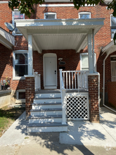
You May Also Like
Similar Rentals Nearby

What Are Walk Score®, Transit Score®, and Bike Score® Ratings?
Walk Score® measures the walkability of any address. Transit Score® measures access to public transit. Bike Score® measures the bikeability of any address.
What is a Sound Score Rating?
A Sound Score Rating aggregates noise caused by vehicle traffic, airplane traffic and local sources
7903 Brookhaven Rd
Milford Mill, MD 21244