

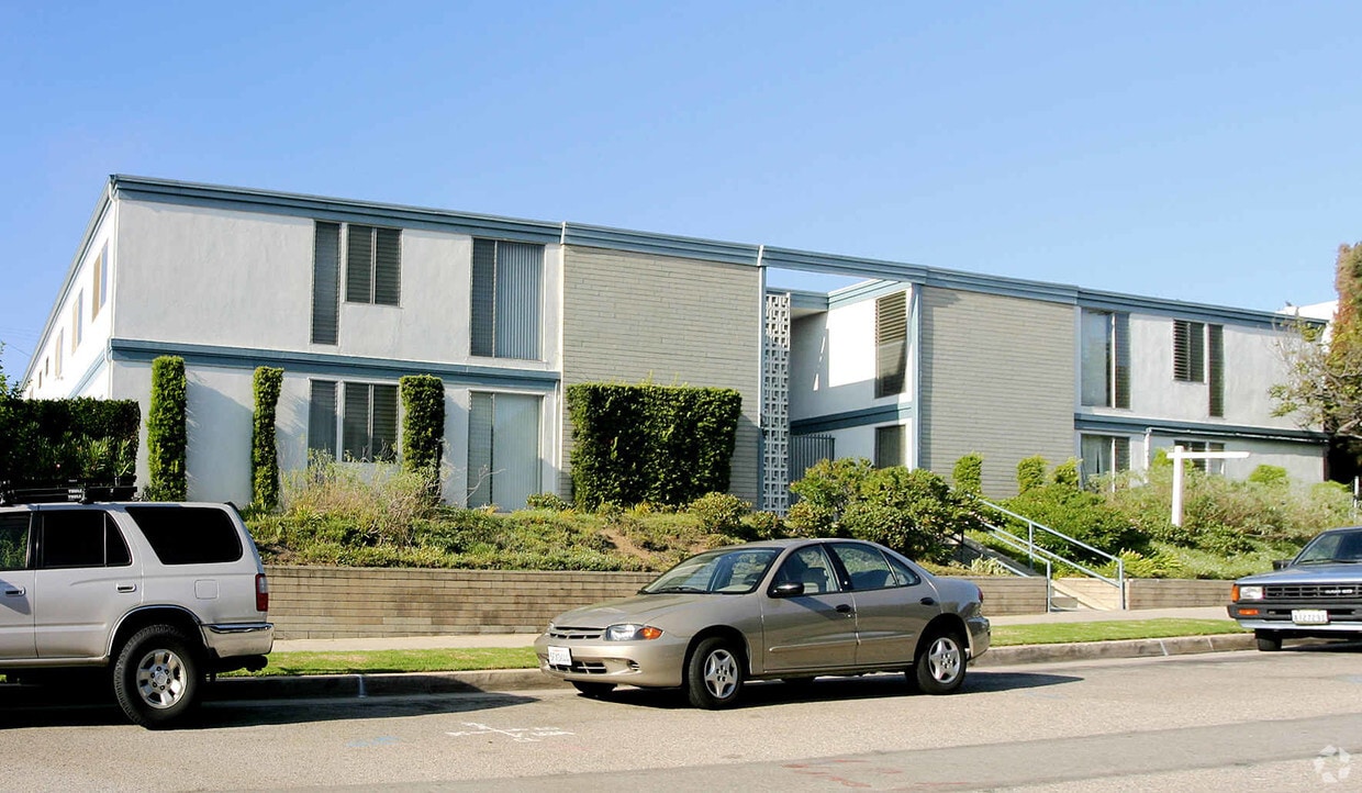
7819 Talbert St
7819 Talbert St,
Playa Del Rey,
CA
90293
-
Monthly Rent
$1,995 - $2,895
-
Bedrooms
1 - 2 bd
-
Bathrooms
1 - 2 ba
-
Square Feet
800 - 1,100 sq ft
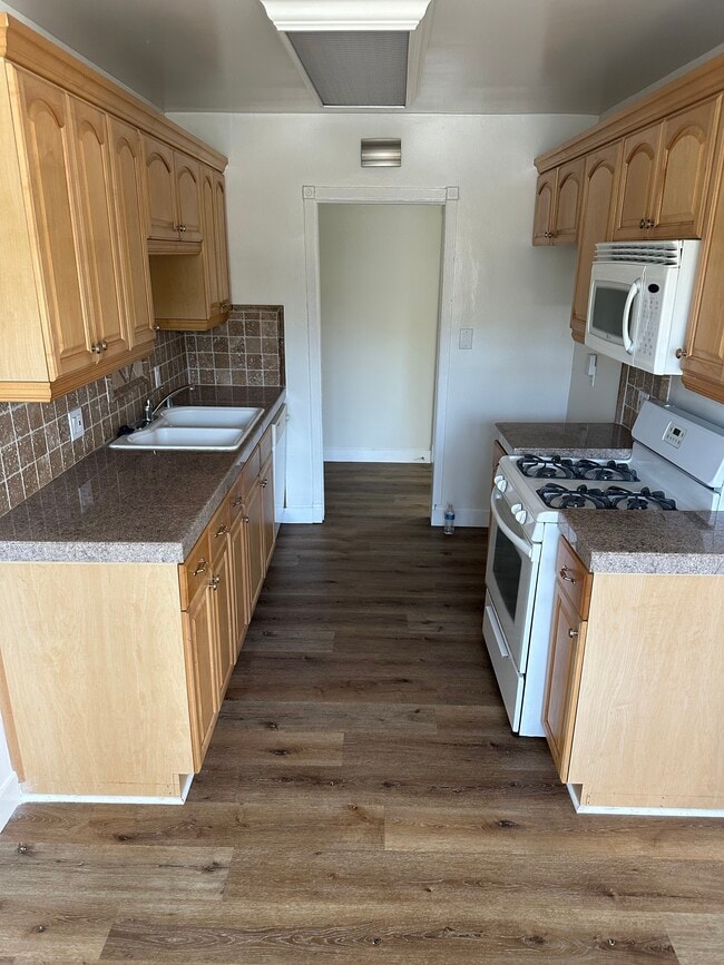
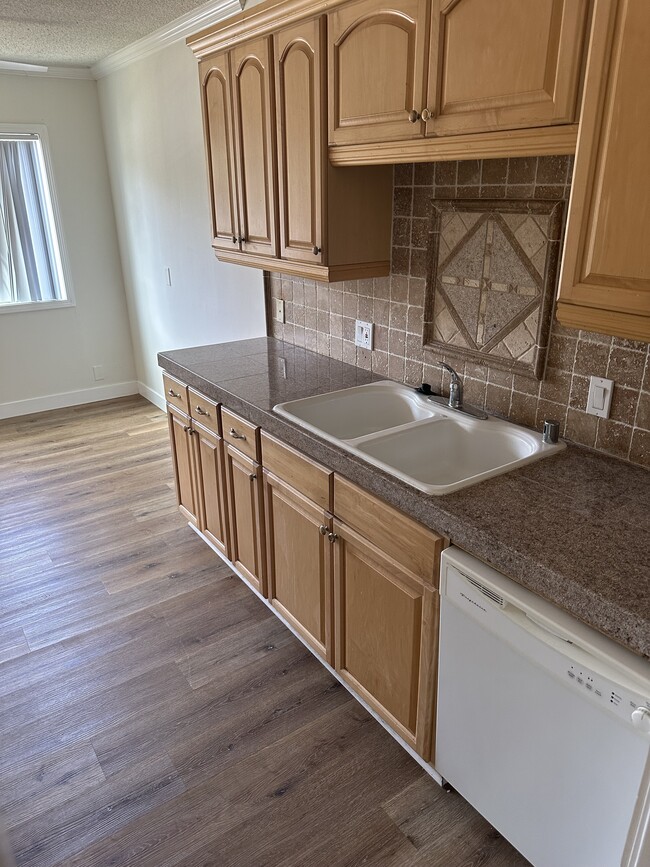
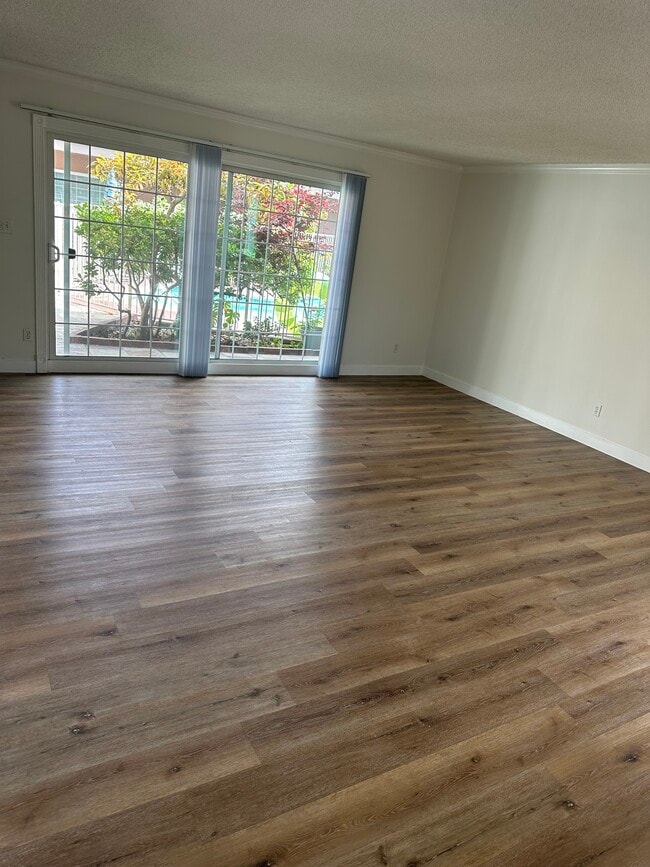
Find your new apartment at 7819 Talbert St. This property is situated in the 90293 area of Playa Del Rey. Let the professional leasing staff show you everything this community has in store. It's time to find your new home. Contact or stop by 7819 Talbert St to discuss your new apartment!
Pricing & Floor Plans
-
Unit 06price $1,995square feet 800availibility Now
-
Unit 04price $2,595square feet 1,100availibility Now
-
Unit 03price $2,595square feet 1,100availibility Now
-
Unit 06price $1,995square feet 800availibility Now
-
Unit 04price $2,595square feet 1,100availibility Now
-
Unit 03price $2,595square feet 1,100availibility Now
Fees and Policies
The fees listed below are community-provided and may exclude utilities or add-ons. All payments are made directly to the property and are non-refundable unless otherwise specified.
-
Surface Lot
Property Fee Disclaimer: Based on community-supplied data and independent market research. Subject to change without notice. May exclude fees for mandatory or optional services and usage-based utilities.
Details
Property Information
-
Built in 1961
-
15 units/2 stories
About 7819 Talbert St Playa Del Rey, CA 90293
Find your new apartment at 7819 Talbert St. This property is situated in the 90293 area of Playa Del Rey. Let the professional leasing staff show you everything this community has in store. It's time to find your new home. Contact or stop by 7819 Talbert St to discuss your new apartment!
7819 Talbert St is an apartment community located in Los Angeles County and the 90293 ZIP Code. This area is served by the Los Angeles Unified attendance zone.
Contact
Apartment Features
- High Speed Internet Access
- Air Conditioning
- Smoke Free
Venice Beach is brimming grit and LA character. This colorful, coastal locale sits in the west side of Los Angeles, and is known for its laid-back, eclectic energy.
You’ll find a distillation of Venice Beach in the street performers, bodybuilders, and beach-goers that congregate at its namesake Beach and Boardwalk. There’s an equally entertaining mix of restaurants, bars, and shops along the boardwalk. You can get your poke and a tattoo all within an afternoon. Even though Venice has retained a lot of its character from the formative Beat Generation that congregated in the neighborhood, there’s plenty of everyday offerings just off the beach. You’ll find premiere local and designer boutiques along Abbot Kinney Blvd, along with food trucks stationed there every first Friday.
There’s a variety of listings here. You’ll find newer, pricier apartments closer to waterfront, with the more characterful listings closer to Lincoln Blvd.
Learn more about living in Venice Beach- High Speed Internet Access
- Air Conditioning
- Smoke Free
| Monday | 12am - 12am |
|---|---|
| Tuesday | 12am - 12am |
| Wednesday | 12am - 12am |
| Thursday | 12am - 12am |
| Friday | 12am - 12am |
| Saturday | 12am - 12am |
| Sunday | 12am - 12am |
| Colleges & Universities | Distance | ||
|---|---|---|---|
| Colleges & Universities | Distance | ||
| Walk: | 20 min | 1.1 mi | |
| Drive: | 4 min | 1.5 mi | |
| Drive: | 12 min | 5.5 mi | |
| Drive: | 13 min | 5.6 mi |


View GreatSchools Rating Methodology
Data provided by GreatSchools.org © 2026. All rights reserved.
Transportation options available in Playa Del Rey include Westchester / Veterans Station, located 3.5 miles from 7819 Talbert St. 7819 Talbert St is near Los Angeles International, located 3.6 miles or 7 minutes away, and Bob Hope, located 26.2 miles or 40 minutes away.
| Transit / Subway | Distance | ||
|---|---|---|---|
| Transit / Subway | Distance | ||
| Drive: | 7 min | 3.5 mi | |
| Drive: | 8 min | 4.2 mi | |
|
|
Drive: | 9 min | 4.9 mi |
| Drive: | 9 min | 5.0 mi | |
|
|
Drive: | 9 min | 5.4 mi |
| Commuter Rail | Distance | ||
|---|---|---|---|
| Commuter Rail | Distance | ||
|
|
Drive: | 29 min | 16.9 mi |
|
|
Drive: | 31 min | 17.1 mi |
| Drive: | 33 min | 20.9 mi | |
|
|
Drive: | 36 min | 22.3 mi |
|
|
Drive: | 38 min | 26.4 mi |
| Airports | Distance | ||
|---|---|---|---|
| Airports | Distance | ||
|
Los Angeles International
|
Drive: | 7 min | 3.6 mi |
|
Bob Hope
|
Drive: | 40 min | 26.2 mi |
Time and distance from 7819 Talbert St.
| Shopping Centers | Distance | ||
|---|---|---|---|
| Shopping Centers | Distance | ||
| Walk: | 18 min | 1.0 mi | |
| Walk: | 18 min | 1.0 mi | |
| Drive: | 3 min | 1.3 mi |
| Parks and Recreation | Distance | ||
|---|---|---|---|
| Parks and Recreation | Distance | ||
|
Ballona Creek Trail - Ballona Wetlands Ecological Reserve Access
|
Drive: | 7 min | 3.6 mi |
|
Dockweiler State Beach
|
Drive: | 7 min | 3.6 mi |
|
Santa Monica Pier Aquarium
|
Drive: | 14 min | 6.9 mi |
|
Santa Monica State Beach
|
Drive: | 15 min | 7.4 mi |
|
Kenneth Hahn State Recreation Area
|
Drive: | 19 min | 9.1 mi |
| Hospitals | Distance | ||
|---|---|---|---|
| Hospitals | Distance | ||
| Drive: | 5 min | 2.6 mi | |
| Drive: | 11 min | 5.9 mi | |
| Drive: | 16 min | 7.5 mi |
| Military Bases | Distance | ||
|---|---|---|---|
| Military Bases | Distance | ||
| Drive: | 10 min | 6.1 mi |
7819 Talbert St Photos
Nearby Apartments
Within 50 Miles of 7819 Talbert St Playa Del Rey, CA 90293
7819 Talbert St does not offer in-unit laundry or shared facilities. Please contact the property to learn about nearby laundry options.
Utilities are not included in rent. Residents should plan to set up and pay for all services separately.
Parking is available at 7819 Talbert St. Contact this property for details.
7819 Talbert St has one to two-bedrooms with rent ranges from $1,995/mo. to $2,895/mo.
7819 Talbert St does not allow pets, though service animals are always welcome in accordance with applicable laws.
A good rule of thumb is to spend no more than 30% of your gross income on rent. Based on the lowest available rent of $1,995 for a one-bedroom, you would need to earn about $79,800 per year to qualify. Want to double-check your budget? Calculate how much rent you can afford with our Rent Affordability Calculator.
7819 Talbert St is not currently offering any rent specials. Check back soon, as promotions change frequently.
While 7819 Talbert St does not offer Matterport 3D tours, renters can request a tour directly through our online platform.
What Are Walk Score®, Transit Score®, and Bike Score® Ratings?
Walk Score® measures the walkability of any address. Transit Score® measures access to public transit. Bike Score® measures the bikeability of any address.
What is a Sound Score Rating?
A Sound Score Rating aggregates noise caused by vehicle traffic, airplane traffic and local sources
7819 Talbert St
Playa Del Rey, CA 90293
Property Manager Responded