
Presidential Towers
555 W Madison St,
Chicago, IL 60661
$1,800 - $4,982
Studio - 2 Beds

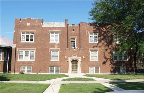
This property is located in Chicago's Chatham neighborhood with easy access to public transportation and nearby shopping for your convenience. The building was recently rehabbed and features faux hardwood floors, a living/dining area, and a nice amount of storage space. Apartments at 7800 S Prairie are equipped with Refrigerator and Stove. This apartment community is located in the 60619 zip code. Choose your preferred apartment; create a guest profile, and a Five T Management property manager will be in touch with you for more details! Once you become a resident of 7800, you will be able to pay your rent online, submit maintenance requests, get community news, and renew your lease by logging in securely to your Resident Portal.
7800 S Prairie is an apartment community located in Cook County and the 60619 ZIP Code. This area is served by the Chicago Public Schools attendance zone.
Unique Features
Situated on Chicago’s South Side, Chatham offers residents an urban aesthetic with rows of classic, red-brick bungalows and apartment buildings in addition to a host of suburban amenities, such as national retailers, chain restaurants, and lush parks.
Chatham’s spirited community also supports a bevy of locally owned businesses, including neighborhood institutions like Dat Donut, Harold’s Chicken Shack, and Fisherman’s Island. Getting around from Chatham is easy with access to several Metrarail stations, the Red Line, and the Dan Ryan Expressway.
Learn more about living in ChathamCompare neighborhood and city base rent averages by bedroom.
| Chatham | Chicago, IL | |
|---|---|---|
| Studio | $746 | $1,632 |
| 1 Bedroom | $974 | $2,023 |
| 2 Bedrooms | $1,150 | $2,543 |
| 3 Bedrooms | $1,333 | $3,064 |
| Colleges & Universities | Distance | ||
|---|---|---|---|
| Colleges & Universities | Distance | ||
| Drive: | 8 min | 3.4 mi | |
| Drive: | 8 min | 3.8 mi | |
| Drive: | 12 min | 6.2 mi | |
| Drive: | 12 min | 6.4 mi |

Transportation options available in Chicago include 79Th Street Station, located 1.1 miles from 7800 S Prairie. 7800 S Prairie is near Chicago Midway International, located 9.7 miles or 19 minutes away, and Chicago O'Hare International, located 26.8 miles or 41 minutes away.
| Transit / Subway | Distance | ||
|---|---|---|---|
| Transit / Subway | Distance | ||
|
|
Drive: | 3 min | 1.1 mi |
|
|
Drive: | 3 min | 1.5 mi |
|
|
Drive: | 4 min | 2.1 mi |
|
|
Drive: | 4 min | 2.3 mi |
|
|
Drive: | 7 min | 3.8 mi |
| Commuter Rail | Distance | ||
|---|---|---|---|
| Commuter Rail | Distance | ||
| Drive: | 2 min | 1.2 mi | |
|
|
Drive: | 4 min | 1.6 mi |
|
|
Drive: | 4 min | 1.7 mi |
|
|
Drive: | 5 min | 2.5 mi |
|
|
Drive: | 5 min | 2.6 mi |
| Airports | Distance | ||
|---|---|---|---|
| Airports | Distance | ||
|
Chicago Midway International
|
Drive: | 19 min | 9.7 mi |
|
Chicago O'Hare International
|
Drive: | 41 min | 26.8 mi |
Scores provided by
Traffic
-Airport
-Businesses
-Scores provided by
HowLoud What is a Sound Score Rating? A Sound Score Rating aggregates noise caused by vehicle traffic, airplane traffic and local sources. How It WorksTime and distance from 7800 S Prairie.
| Shopping Centers | Distance | ||
|---|---|---|---|
| Shopping Centers | Distance | ||
| Walk: | 13 min | 0.7 mi | |
| Drive: | 4 min | 1.7 mi | |
| Drive: | 4 min | 1.8 mi |
| Parks and Recreation | Distance | ||
|---|---|---|---|
| Parks and Recreation | Distance | ||
|
Hamilton Park
|
Drive: | 4 min | 1.5 mi |
|
Avalon Park
|
Drive: | 5 min | 2.0 mi |
|
Foster Park
|
Drive: | 7 min | 3.1 mi |
|
Ogden Park
|
Drive: | 8 min | 3.6 mi |
|
Jackson Park
|
Drive: | 7 min | 3.7 mi |
| Hospitals | Distance | ||
|---|---|---|---|
| Hospitals | Distance | ||
| Drive: | 4 min | 2.2 mi | |
| Drive: | 6 min | 2.9 mi | |
| Drive: | 6 min | 3.1 mi |
What Are Walk Score®, Transit Score®, and Bike Score® Ratings?
Walk Score® measures the walkability of any address. Transit Score® measures access to public transit. Bike Score® measures the bikeability of any address.
What is a Sound Score Rating?
A Sound Score Rating aggregates noise caused by vehicle traffic, airplane traffic and local sources.
7800 S Prairie Ave
Chicago, IL 60619


