-
7642 Crescent Ave

-
7642 Crescent Ave
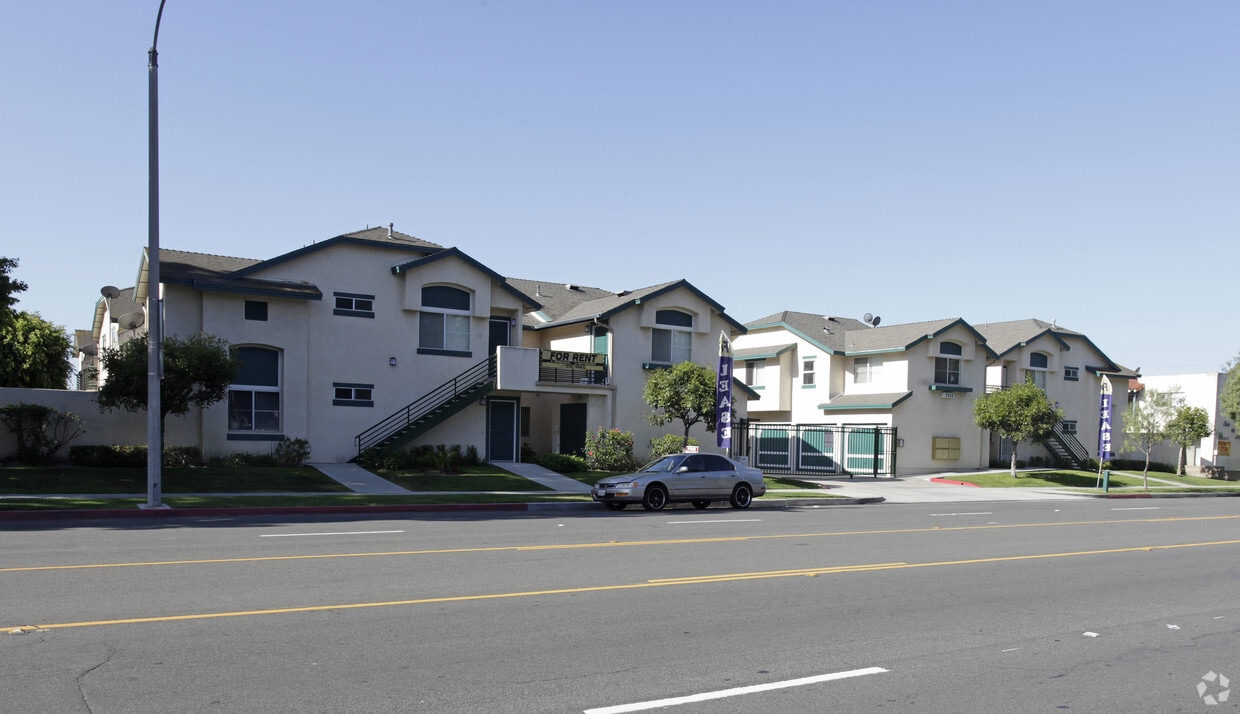
7642-7652 Crescent Ave
7642-7652 Crescent Ave,
Buena Park,
CA
90620
-
Monthly Rent
$1,500
-
Bedrooms
2 bd
-
Bathrooms
2 ba
-
Square Feet
1,000 sq ft

Discover your new home at 7642-7652 Crescent Ave in Buena Park, CA. The 90620 location in Buena Park is an ideal place to live. The leasing staff is ready to help you find the perfect floorplan option. Make a visit to check out the apartment floorplan options. It's time to find your next place. Contact or stop by the 7642-7652 Crescent Ave leasing office to check the current floorplan availability today.
Pricing & Floor Plans
Fees and Policies
The fees listed below are community-provided and may exclude utilities or add-ons. All payments are made directly to the property and are non-refundable unless otherwise specified.
-
One-Time Basics
-
Administrative Fee$0
-
Application Fee Per Applicant$40
-
Property Fee Disclaimer: Based on community-supplied data and independent market research. Subject to change without notice. May exclude fees for mandatory or optional services and usage-based utilities.
Details
Utilities Included
-
Water
-
Trash Removal
-
Sewer
Property Information
-
Built in 1970
-
20 units/2 stories
About 7642-7652 Crescent Ave Buena Park, CA 90620
Discover your new home at 7642-7652 Crescent Ave in Buena Park, CA. The 90620 location in Buena Park is an ideal place to live. The leasing staff is ready to help you find the perfect floorplan option. Make a visit to check out the apartment floorplan options. It's time to find your next place. Contact or stop by the 7642-7652 Crescent Ave leasing office to check the current floorplan availability today.
7642-7652 Crescent Ave is an apartment community located in Orange County and the 90620 ZIP Code. This area is served by the Anaheim Union High attendance zone.
Contact
Community Amenities
- Laundry Facilities
- Picnic Area
Apartment Features
Air Conditioning
Washer/Dryer Hookup
Tile Floors
Heating
- Washer/Dryer Hookup
- Air Conditioning
- Heating
- Tile Floors
Welcome to Buena Park, a Southern California community where entertainment meets suburban living. Located in Orange County, this city offers diverse rental options from apartments to single-family homes, with current average rents starting at $1,725 for studios and reaching $2,831 for four-bedroom residences. The rental market shows steady growth, with most unit types experiencing modest year-over-year increases between 0.8% and 2.5%. The neighborhoods near Knott's Berry Farm offer entertainment-district living, while areas near Ralph B. Clark Regional Park provide a more residential setting.
This Orange County city features attractions that enhance daily life. Knott's Berry Farm, which began as a berry stand before becoming America's first theme park, stands as a historic landmark drawing visitors throughout the year. The 105-acre Ralph B. Clark Regional Park offers walking trails, fishing spots, and an interpretive center housing ice age fossils.
Learn more about living in Buena Park- Laundry Facilities
- Picnic Area
- Washer/Dryer Hookup
- Air Conditioning
- Heating
- Tile Floors
| Monday | By Appointment |
|---|---|
| Tuesday | By Appointment |
| Wednesday | By Appointment |
| Thursday | By Appointment |
| Friday | By Appointment |
| Saturday | By Appointment |
| Sunday | By Appointment |
| Colleges & Universities | Distance | ||
|---|---|---|---|
| Colleges & Universities | Distance | ||
| Drive: | 5 min | 2.2 mi | |
| Drive: | 13 min | 6.1 mi | |
| Drive: | 13 min | 7.7 mi | |
| Drive: | 14 min | 8.2 mi |


View GreatSchools Rating Methodology
Data provided by GreatSchools.org © 2026. All rights reserved.
Transportation options available in Buena Park include Norwalk, located 10.2 miles from 7642-7652 Crescent Ave. 7642-7652 Crescent Ave is near Long Beach (Daugherty Field), located 11.7 miles or 22 minutes away, and John Wayne/Orange County, located 16.1 miles or 25 minutes away.
| Transit / Subway | Distance | ||
|---|---|---|---|
| Transit / Subway | Distance | ||
|
|
Drive: | 14 min | 10.2 mi |
|
|
Drive: | 18 min | 12.6 mi |
| Commuter Rail | Distance | ||
|---|---|---|---|
| Commuter Rail | Distance | ||
|
|
Drive: | 8 min | 3.8 mi |
|
|
Drive: | 12 min | 7.2 mi |
|
|
Drive: | 14 min | 8.3 mi |
|
|
Drive: | 17 min | 9.0 mi |
| Drive: | 17 min | 9.2 mi |
| Airports | Distance | ||
|---|---|---|---|
| Airports | Distance | ||
|
Long Beach (Daugherty Field)
|
Drive: | 22 min | 11.7 mi |
|
John Wayne/Orange County
|
Drive: | 25 min | 16.1 mi |
Time and distance from 7642-7652 Crescent Ave.
| Shopping Centers | Distance | ||
|---|---|---|---|
| Shopping Centers | Distance | ||
| Walk: | 8 min | 0.4 mi | |
| Walk: | 13 min | 0.7 mi | |
| Drive: | 3 min | 1.1 mi |
| Parks and Recreation | Distance | ||
|---|---|---|---|
| Parks and Recreation | Distance | ||
|
El Dorado Nature Center
|
Drive: | 14 min | 8.2 mi |
|
Children's Museum at La Habra
|
Drive: | 16 min | 8.4 mi |
|
La Habra Historical Museum
|
Drive: | 15 min | 8.7 mi |
|
El Dorado East Regional Park
|
Drive: | 17 min | 9.1 mi |
|
Anaheim Equestrian Center
|
Drive: | 16 min | 11.4 mi |
| Hospitals | Distance | ||
|---|---|---|---|
| Hospitals | Distance | ||
| Drive: | 2 min | 1.4 mi | |
| Drive: | 5 min | 2.8 mi | |
| Drive: | 9 min | 4.4 mi |
| Military Bases | Distance | ||
|---|---|---|---|
| Military Bases | Distance | ||
| Drive: | 12 min | 5.8 mi |
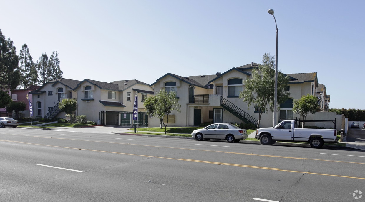
7642-7652 Crescent Ave Photos
-
7642 Crescent Ave
-
7642 Crescent Ave
While 7642-7652 Crescent Ave does not provide in‑unit laundry, on‑site laundry facilities are available for shared resident use.
Select utilities are included in rent at 7642-7652 Crescent Ave, including water, trash removal, and sewer. Residents are responsible for any other utilities not listed.
Contact this property for parking details.
7642-7652 Crescent Ave has two-bedrooms apartments renting for $1,500/mo.
7642-7652 Crescent Ave does not allow pets, though service animals are always welcome in accordance with applicable laws.
A good rule of thumb is to spend no more than 30% of your gross income on rent. Based on the lowest available rent of $1,500 for a two-bedrooms, you would need to earn about $60,000 per year to qualify. Want to double-check your budget? Calculate how much rent you can afford with our Rent Affordability Calculator.
7642-7652 Crescent Ave is not currently offering any rent specials. Check back soon, as promotions change frequently.
While 7642-7652 Crescent Ave does not offer Matterport 3D tours, renters can request a tour directly through our online platform.
What Are Walk Score®, Transit Score®, and Bike Score® Ratings?
Walk Score® measures the walkability of any address. Transit Score® measures access to public transit. Bike Score® measures the bikeability of any address.
What is a Sound Score Rating?
A Sound Score Rating aggregates noise caused by vehicle traffic, airplane traffic and local sources
7642-7652 Crescent Ave
Buena Park, CA 90620
Property Manager Responded