


$2,250 / Month
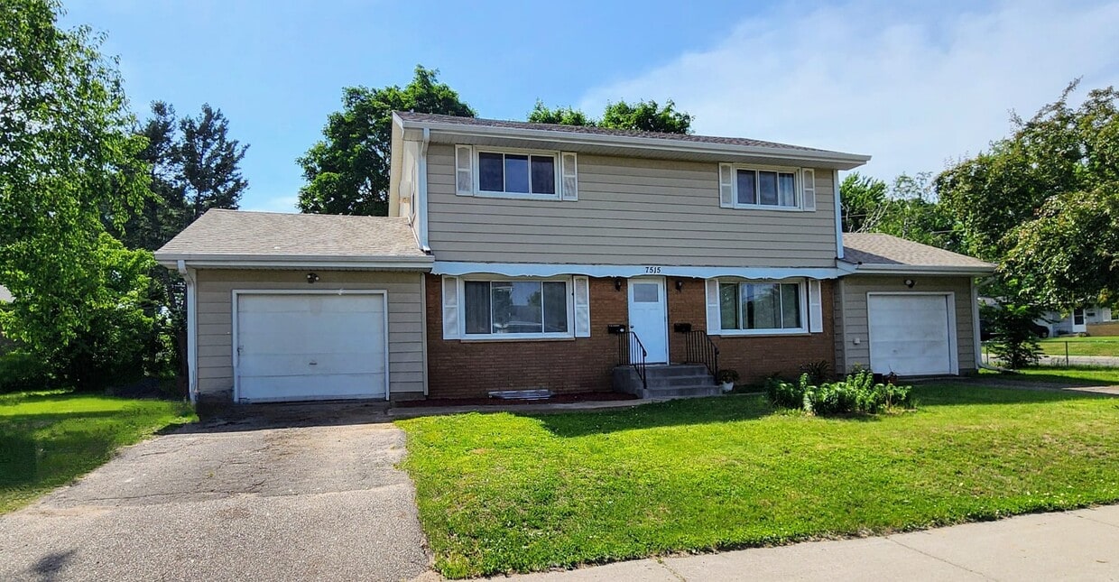
7515 Cloman Way E
Inver Grove Heights, MN 55076
Today
Favorites
651-497-8425
-
Bedrooms
3
-
Bathrooms
2
-
Square Feet
--
-
Available
Available Now
7515 Cloman Way E

Favorites
About This Home
$2,250 deposit,
Available Now
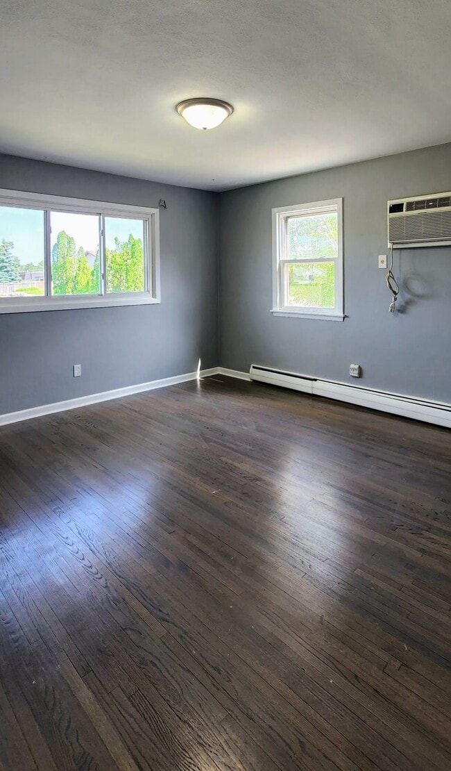
**Freshly Updated 3-Bedroom Home – Available Now!** This well-maintained **3 bedroom, 2 bathroom** home features a **1-car garage** and a **spacious yard**, perfect for outdoor enjoyment. The **lower level has been recently updated**, now offering a **third bedroom with an egress window**, a brand-new **3/4 shower**, and a **new washer and dryer** for added convenience. Located just minutes from **local schools, shopping centers, and major highway access**, this home is ideally situated for comfortable and connected living. **Call today to schedule your private showing!** **Freshly Updated 3-Bedroom Home – Available Now!** This well-maintained **3 bedroom, 2 bathroom** home features a **1-car garage** and a **spacious yard**, perfect for outdoor enjoyment. The **lower level has been recently updated**, now offering a **third bedroom with an egress window**, a brand-new **3/4 shower**, and a **new washer and dryer** for added convenience. Located just minutes from **local schools, shopping centers, and major highway access**, this home is ideally situated for comfortable and connected living. **Call today to schedule your private showing!**
7515 Cloman Way E is a house located in Dakota County and the 55076 ZIP Code. This area is served by the Inver Grove Heights Schools attendance zone.
* Price shown is base rent and may not include non-optional fees and utilities.
Price, availability, fees, and any applicable rent special are subject to change without notice.
* Square footage definitions vary. Displayed square footage is approximate.
Contact
- Listed by Marcos Lozano
- Phone Number
- Contact
Location
Get Directions
Just off the eastern bank of the Mississippi River, Inver Grove Heights, Minnesota has all the natural beauty expected from the state known for its grassy rolling plains. South of the Twin Cities, Inver Grove Heights is a suburb of Saint Paul. This residential city provides easy access to the surrounding areas thanks to the highway that runs through the city, Highway 52.
Residents of this quiet town enjoy several events and volunteer opportunities that keeps people of Inver Grove Heights connected. There are also many local parks and a community center that provides the community with a variety of recreation opportunities and programs. The new development within the area makes Inver Grove a city with a pleasant mix of both old and new.
Learn more about living in Inver Grove Heights
Education
| Colleges & Universities | Distance | ||
|---|---|---|---|
| Colleges & Universities | Distance | ||
| Drive: | 6 min | 2.0 mi | |
| Drive: | 16 min | 8.2 mi | |
| Drive: | 17 min | 10.2 mi | |
| Drive: | 18 min | 10.7 mi |
7515 Cloman Way E is within 6 minutes or 2.0 miles from Inver Hills Community College. It is also near Argosy University, Twin Cities and Saint Paul College.
Schools


Public Elementary School
Grades PK-5
574 Students
Attendance Zone
Public Elementary School
Grades PK-5
655 Students
Nearby
Public Middle School
Grades 6-8
761 Students
Attendance Zone
Public High School
Grades 9-12
1,062 Students
Attendance Zone
Private Elementary School
Grades PK-6
24 Students
Nearby
Private Elementary, Middle & High School
Grades PK-12
40 Students
Nearby
School data provided by
 The GreatSchools Rating helps parents compare schools within a state based on a variety of school quality indicators and provides a helpful picture of how effectively each school serves all of its students. Ratings are on a scale of 1 (below average) to 10 (above average) and can include test scores, college readiness, academic progress, advanced courses, equity, discipline and attendance data. We also advise parents to visit schools, consider other information on school performance and programs, and consider family needs as part of the school selection process.
View GreatSchools Rating Methodology
Data provided by GreatSchools.org © 2025. All rights reserved.
View GreatSchools Rating Methodology
Data provided by GreatSchools.org © 2025. All rights reserved.
Transportation options available in Inver Grove Heights include Central Station, located 9.5 miles from 7515 Cloman Way E. 7515 Cloman Way E is near Minneapolis-St Paul International/Wold-Chamberlain, located 12.4 miles or 22 minutes away.
| Transit / Subway | Distance | ||
|---|---|---|---|
| Transit / Subway | Distance | ||
| Drive: | 16 min | 9.5 mi | |
| Drive: | 16 min | 9.5 mi | |
| Drive: | 16 min | 9.7 mi | |
| Drive: | 17 min | 10.0 mi | |
| Drive: | 17 min | 10.1 mi |
| Commuter Rail | Distance | ||
|---|---|---|---|
| Commuter Rail | Distance | ||
|
|
Drive: | 16 min | 9.8 mi |
| Drive: | 35 min | 20.4 mi | |
| Drive: | 37 min | 25.9 mi | |
| Drive: | 47 min | 34.4 mi | |
| Drive: | 49 min | 36.1 mi |
| Airports | Distance | ||
|---|---|---|---|
| Airports | Distance | ||
|
Minneapolis-St Paul International/Wold-Chamberlain
|
Drive: | 22 min | 12.4 mi |
Time and distance from 7515 Cloman Way E.
| Shopping Centers | Distance | ||
|---|---|---|---|
| Shopping Centers | Distance | ||
| Walk: | 14 min | 0.7 mi | |
| Walk: | 18 min | 1.0 mi | |
| Drive: | 4 min | 1.5 mi |
7515 Cloman Way E has 3 shopping centers within 1.5 miles, which is about a 4-minute walk. The miles and minutes will be for the farthest away property.
| Parks and Recreation | Distance | ||
|---|---|---|---|
| Parks and Recreation | Distance | ||
|
Dodge Nature Center
|
Drive: | 13 min | 6.8 mi |
|
Cherokee Regional Park
|
Drive: | 18 min | 9.7 mi |
|
Spring Lake Reserve
|
Drive: | 19 min | 10.4 mi |
|
Indian Mounds Park
|
Drive: | 17 min | 10.7 mi |
|
Crosby Farm Regional Park
|
Drive: | 19 min | 10.9 mi |
7515 Cloman Way E has 5 parks within 10.9 miles, including Dodge Nature Center, Cherokee Regional Park, and Spring Lake Reserve.
| Hospitals | Distance | ||
|---|---|---|---|
| Hospitals | Distance | ||
| Drive: | 17 min | 10.1 mi | |
| Drive: | 17 min | 10.4 mi | |
| Drive: | 18 min | 10.5 mi |
7515 Cloman Way E has 3 hospitals within 10.5 miles, the nearest is St. Joseph's Hospital which is 10.1 miles away and a 17 minute drive.
| Military Bases | Distance | ||
|---|---|---|---|
| Military Bases | Distance | ||
| Drive: | 20 min | 11.3 mi |
7515 Cloman Way E is 11.3 miles and a 20 minute drive from Fort Snelling Military Reservation.
You May Also Like
Similar Rentals Nearby


What Are Walk Score®, Transit Score®, and Bike Score® Ratings?
Walk Score® measures the walkability of any address. Transit Score® measures access to public transit. Bike Score® measures the bikeability of any address.
What is a Sound Score Rating?
A Sound Score Rating aggregates noise caused by vehicle traffic, airplane traffic and local sources
7515 Cloman Way E
Inver Grove Heights, MN 55076