

$3,400 / Month
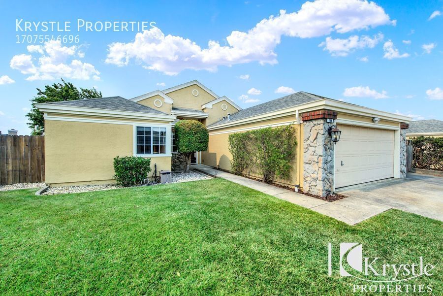
748 Primrose Ln
Benicia, CA 94510
2 Weeks Ago
Favorites
748 Primrose Ln

Favorites
Check Back Soon for Upcoming Availability
| Beds | Baths | Average SF |
|---|---|---|
| 3 Bedrooms 3 Bedrooms 3 Br | 2 Baths 2 Baths 2 Ba | 1,636 SF |
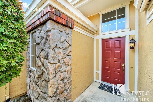
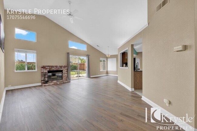
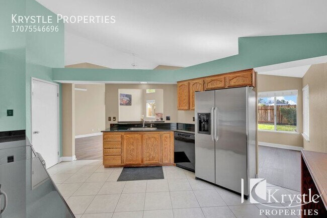
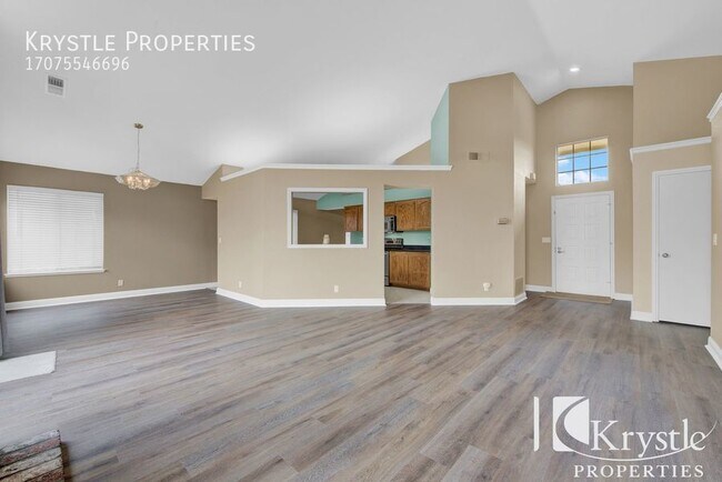
About This Property
---- SCHEDULE A SHOWING ONLINE AT: http://showmojo.com/lac/2a2add90d6 ---- ****Presented exclusively with Krystle Properties**** Well maintained single story home nestled in the hills off Rose Dr. located in a highly sought after neighborhood of Benicia. Spacious layout with high ceilings and an open floor plan. Includes family & living room, large, well maintained yards. Adorable master suite includes two closets and a bathtub with jets.. Upgrades include all new vinyl flooring, granite counters in kitchen, automatic sprinklers, RV or boat parking, indoor laundry. Two car garage. Landscaping included. Only one mile to Matthew Turner Elementary school, Benicia Community Park and Benicia Skate park. 5 minute stroll to Gateway Park. Just two miles away is CVS, Starbucks, Restaurants, coffee shops, gas station, Benicia State Park and HWY 780 on ramp. REQUIREMENTS: ~FICO score of 700+optimal; 640-699 may require cosignor or higher deposit ~FICO below 640 may be automatic denial ~Good rental references ~Verifiable income of 3 times the rent ~NO EVICTIONS To apply, visit: http://www.krystleproperties.com/apply/ Due to third party listing errors and to receive most up to date and accurate information, please refer to our website at www.KrystleProperties.com To schedule an appointment to view the interior and to verify listing information, visit http://www.krystleproperties.com/viewnow
748 Primrose Ln is a house located in Solano County and the 94510 ZIP Code. This area is served by the Benicia Unified attendance zone.
Location
Get Directions
Situated along the Carquinez Strait in the San Francisco Bay Area, Benicia is a scenic waterfront city rich in history, cultural amenities, and sweeping vistas. Benicia boasts an irresistible historic charm, especially in its quaint downtown area, which is brimming with one-of-a-kind shops, delectable eateries, and vibrant artists’ studios.
Founded in 1847, Benicia once served as California’s state capital for 13 months, and now touts the only state capitol building outside of Sacramento. Residents and visitors alike can uncover much of Benicia’s past at the Benicia Historical Museum.
Nearly 500 acres of parkland provides ample green space and tranquil trails for all kinds of outdoor recreation. Benicia’s thriving arts community creates a broad range of art, from glass art and sculptures to theatrical plays and music. Benicia’s friendly community comes together for a variety of events, like the Downtown Farmers Market, Opening Day on the Strait, and artist studio open houses.
Learn more about living in Benicia
Education
| Colleges & Universities | Distance | ||
|---|---|---|---|
| Colleges & Universities | Distance | ||
| Drive: | 21 min | 10.1 mi | |
| Drive: | 21 min | 12.3 mi | |
| Drive: | 25 min | 15.9 mi | |
| Drive: | 26 min | 16.4 mi |
748 Primrose Ln is within 21 minutes or 10.1 miles from Touro University California. It is also near Diablo Valley, Pleasant Hill and Solano Community College.
Schools


Public Elementary School
Grades K-5
440 Students
Nearby
Public Elementary School
Grades K-5
508 Students
Attendance Zone
Public Middle School
Grades 6-8
986 Students
Attendance Zone
Public High School
Grades 9-12
1,432 Students
Attendance Zone
Private Elementary School
Grades PK-1
6 Students
Nearby
Private Elementary & Middle School
Grades PK-8
333 Students
Nearby
Private Middle & High School
Grades 7-12
Nearby
Private Middle & High School
Grades 8-12
Nearby
School data provided by
 The GreatSchools Rating helps parents compare schools within a state based on a variety of school quality indicators and provides a helpful picture of how effectively each school serves all of its students. Ratings are on a scale of 1 (below average) to 10 (above average) and can include test scores, college readiness, academic progress, advanced courses, equity, discipline and attendance data. We also advise parents to visit schools, consider other information on school performance and programs, and consider family needs as part of the school selection process.
View GreatSchools Rating Methodology
Data provided by GreatSchools.org © 2025. All rights reserved.
View GreatSchools Rating Methodology
Data provided by GreatSchools.org © 2025. All rights reserved.
Transportation options available in Benicia include North Concord Martinez Station, located 13.4 miles from 748 Primrose Ln. 748 Primrose Ln is near Metro Oakland International, located 38.5 miles or 53 minutes away, and San Francisco International, located 46.2 miles or 65 minutes away.
| Transit / Subway | Distance | ||
|---|---|---|---|
| Transit / Subway | Distance | ||
|
|
Drive: | 22 min | 13.4 mi |
|
|
Drive: | 22 min | 13.4 mi |
| Commuter Rail | Distance | ||
|---|---|---|---|
| Commuter Rail | Distance | ||
|
|
Drive: | 15 min | 8.4 mi |
|
|
Drive: | 29 min | 19.9 mi |
| Drive: | 30 min | 20.0 mi | |
|
|
Drive: | 34 min | 24.1 mi |
|
|
Drive: | 37 min | 25.7 mi |
| Airports | Distance | ||
|---|---|---|---|
| Airports | Distance | ||
|
Metro Oakland International
|
Drive: | 53 min | 38.5 mi |
|
San Francisco International
|
Drive: | 65 min | 46.2 mi |
Time and distance from 748 Primrose Ln.
| Shopping Centers | Distance | ||
|---|---|---|---|
| Shopping Centers | Distance | ||
| Drive: | 6 min | 1.9 mi | |
| Drive: | 6 min | 1.9 mi | |
| Drive: | 6 min | 2.0 mi |
748 Primrose Ln has 3 shopping centers within 2.0 miles, which is about a 6-minute drive. The miles and minutes will be for the farthest away property.
| Parks and Recreation | Distance | ||
|---|---|---|---|
| Parks and Recreation | Distance | ||
|
Benicia State Recreation Area
|
Drive: | 9 min | 2.9 mi |
|
Benicia Capitol State Historic Park
|
Drive: | 9 min | 3.9 mi |
|
Six Flags Discovery Kingdom
|
Drive: | 15 min | 8.2 mi |
|
Crockett Hills Regional Park
|
Drive: | 15 min | 8.2 mi |
|
Carquinez Strait Regional Shoreline
|
Drive: | 20 min | 10.4 mi |
748 Primrose Ln has 5 parks within 10.4 miles, including Benicia State Recreation Area, Benicia Capitol State Historic Park, and Six Flags Discovery Kingdom.
| Hospitals | Distance | ||
|---|---|---|---|
| Hospitals | Distance | ||
| Drive: | 14 min | 7.1 mi | |
| Drive: | 15 min | 8.1 mi | |
| Drive: | 15 min | 8.3 mi |
748 Primrose Ln has 3 hospitals within 8.3 miles, the nearest is Adventist Health Vallejo which is 7.1 miles away and a 14 minute drive.
| Military Bases | Distance | ||
|---|---|---|---|
| Military Bases | Distance | ||
| Drive: | 11 min | 4.5 mi | |
| Drive: | 20 min | 9.5 mi |
748 Primrose Ln is 4.5 miles from Armory Vallejo, and is convenient to other military bases, including Mare Island Naval Reserve.
You May Also Like
Similar Rentals Nearby


What Are Walk Score®, Transit Score®, and Bike Score® Ratings?
Walk Score® measures the walkability of any address. Transit Score® measures access to public transit. Bike Score® measures the bikeability of any address.
What is a Sound Score Rating?
A Sound Score Rating aggregates noise caused by vehicle traffic, airplane traffic and local sources
748 Primrose Ln
Benicia, CA 94510