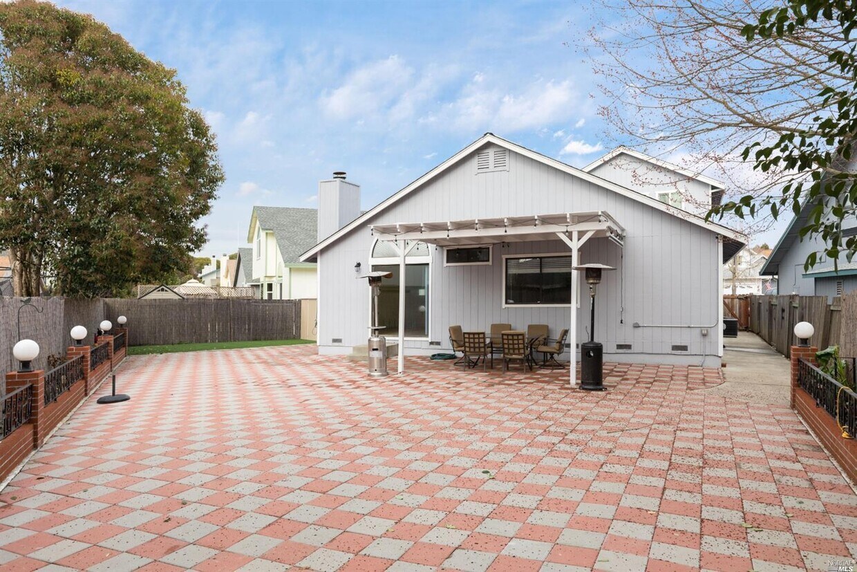
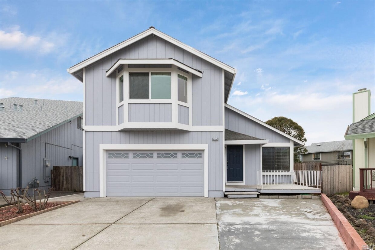
$4,250 / Month

7451 Michael Way

,

Rohnert Park, CA 94928

Today
| Edit

Under 30 minutes

Commute Time is calculated at rush hour.
Share Listing
Favorites
512-587-8556
  • Bedrooms

    4

  • Bathrooms

    3

  • Square Feet

    1,868 sq ft

  • Available

    Available Now

Highlights

  • 2 Car Attached Garage
  • Central Heating
7451 Michael Way
Share Listing
Favorites

About This Home

Available Now

Very roomy, comfortable two level home. Three bedrooms and two baths on lower level, Primary Bedroom and Ensuite Bath on upper level. Open floor plan kitchen and dining/family area. Spacious back yard. Close to SSU. Co-Signers welcome. Available June, 2026! Sorry, no pets allowed. MLS#326027430

7451 Michael Way is a house located in Sonoma County and the 94928 ZIP Code. This area is served by the Cotati-Rohnert Park Unified School District attendance zone.

* Price shown is base rent. Excludes user-selected optional fees and variable or usage-based fees and required charges due at or prior to move-in or at move-out. Price, availability, fees, and any applicable rent special are subject to change without notice.
* Square footage definitions vary. Displayed square footage is approximate.

Home Details

Home Type

Single Family Detached Home

Year Built

Built in 1991

Bedrooms and Bathrooms

3 Full Bathrooms 4 Bedrooms

Interior Spaces

1,868 Sq Ft Home 2-Story Property

Laundry

Dryer Washer

Listing and Financial Details

Security Deposit $4,250 Assessor Parcel Number 047-490-051-000

Lot Details

6,216 Sq Ft Lot

Parking

2 Car Attached Garage

Utilities

Central Heating

Community Details

Fees and Policies

The fees listed below are community-provided and may exclude utilities or add-ons. All payments are made directly to the property and are non-refundable unless otherwise specified.

  • Garage - Attached

Property Fee Disclaimer: Based on community-supplied data and independent market research. Subject to change without notice. May exclude fees for mandatory or optional services and usage-based utilities.

Contact

  • Listed by Dustin Littlefield | Safer Properties
  • Phone Number
  • Contact
  • Source
    BAREIS MLS ®
Copyright 2026, Bay Area Real Estate Information Services, Inc. All Rights Reserved.
City - Rohnert Park

Rohnert Park sits at a practical crossroads in Sonoma County, close enough to San Francisco to access the Bay Area's economy yet far enough to feel like its own grounded, walkable community. Built as one of California's early planned cities, the layout is intentional—wide streets, interconnected bike paths, and a string of neighborhood parks give the city an open, unhurried character. Sonoma State University anchors the northwest side of town, drawing a steady mix of students, educators, and researchers who contribute to the city's lively arts and cultural calendar. The Spreckels Performing Arts Center and the Green Music Center on campus regularly bring theater, symphony performances, and live concerts to residents.

Neighborhood options range from established single-family areas to newer developments closer to the Rohnert Park Expressway corridor.

Learn more about living in Rohnert Park 
Education
Colleges & Universities Distance
Walk: 15 min 0.8 mi
Drive: 14 min 6.9 mi
Drive: 18 min 11.2 mi
Drive: 64 min 39.1 mi
7451 Michael Way is within 15 minutes or 0.8 mile from Sonoma State University. It is also near Santa Rosa Jr Coll., Petaluma and Santa Rosa Jr Coll..
Schools
Public Elementary School
Grades K-5
489 Students
Nearby
Public High School
Grades 9-12
Nearby
Transportation

7451 Michael Way is near Charles M Schulz - Sonoma County, located 17.0 miles or 25 minutes away.

Commuter Rail Distance
Drive: 3 min 1.2 mi
Drive: 6 min 2.0 mi
Drive: 12 min 6.1 mi
Drive: 14 min 9.2 mi
Drive: 15 min 10.6 mi
Airports Distance
Airports Distance
Charles M Schulz - Sonoma County
Drive: 25 min 17.0 mi
Getting Around
Fairly Walkable
Walkability
40 / 100
Limited Public Transit
Transit
30 / 100
Very Drivable
Drivability
80 / 100
Moderately Bikeable
Bikeability
60 / 100

Scores provided by

What do Walkability, Transit, Drivability, and Bikeability mean? Walkability measures the walking distance to day-to-day needs. Transit measures access to public transportation. Drivability measures congestion, parking availability, and access to major roads. Bikeability measures the suitability for cycling. How It Works
Active
Soundscore
76 / 100

Traffic

Active

Airport

Calm

Businesses

Calm

Scores provided by

HowLoud What is a Sound Score Rating? A Sound Score Rating aggregates noise caused by vehicle traffic, airplane traffic and local sources. How It Works
Points of Interest

Time and distance from 7451 Michael Way.

Shopping Centers Distance
Walk: 3 min 0.2 mi
Walk: 12 min 0.7 mi
Walk: 13 min 0.7 mi
7451 Michael Way has 3 shopping centers within 0.7 mile, which is about a 13-minute walk. The miles and minutes will be for the farthest away property.
Parks and Recreation Distance
Sonoma State Univ. Observatory
Walk: 13 min 0.7 mi
Crane Creek Regional Park
Drive: 11 min 4.1 mi
Hunter Creek Trail
Drive: 12 min 5.6 mi
Fairfield Osborn Preserve
Drive: 19 min 6.2 mi
Colgan Creek Trail
Drive: 12 min 7.2 mi
7451 Michael Way has 5 parks within 7.2 miles, including Sonoma State Univ. Observatory, Crane Creek Regional Park, and Hunter Creek Trail.
Hospitals Distance
Hospitals Distance
Drive: 14 min 7.7 mi
Drive: 15 min 9.9 mi
Drive: 16 min 11.5 mi
7451 Michael Way has 3 hospitals within 11.5 miles, the nearest is Petaluma Valley Hospital which is 7.7 miles away and a 14 minute drive.
Military Bases Distance
Drive: 51 min 35.5 mi
7451 Michael Way is 35.5 miles and a 51 minute drive from Mare Island Naval Reserve.

You May Also Like

Similar Rentals Nearby