$2,100
Total Monthly Price
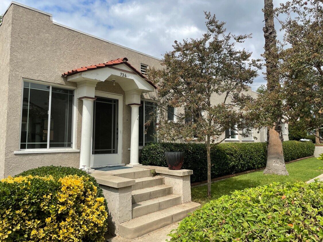
736 Santa Barbara St Unit 736
Pasadena, CA 91101
2 Weeks Ago
|
Edit
Favorites
736 Santa Barbara St Unit 736

Favorites
Check Back Soon for Upcoming Availability
| Beds | Baths | Average SF |
|---|---|---|
| 1 Bedroom 1 Bedroom 1 Br | 1 Bath 1 Bath 1 Ba | 800 SF |
Fees and Policies
The fees listed below are community-provided and may exclude utilities or add-ons. All payments are made directly to the property and are non-refundable unless otherwise specified.
- Parking
-
Covered--
Details
Utilities Included
-
Water
-
Sewer
Property Information
-
2 units
About This Property
Located on a quiet street, this well appointed classic Pasadena bungalow has great appeal. Large rooms, the dining/living area provide nice open airy feel. Ample lighting with upgrades all while maintaining a classic feel. Gold line and freeway close. This is a must see.
736 Santa Barbara St is an apartment community located in Los Angeles County and the 91101 ZIP Code.
Apartment Features
- Laundry Facilities
736 Santa Barbara St,
Pasadena,
CA
91101
Pasadena’s Olive Heights neighborhood provides a subdued suburban refuge from the often-manic energy of the region. Lake Avenue’s dining and shopping options are within easy walking distance of anywhere in the community, and Madison Elementary School’s location on the east side makes it easy for local schoolchildren to walk to class quickly and safely.
Downtown Pasadena is only a few blocks to the south, and the Cal Tech campus is less than ten minutes away by car. With easy access to the 210 freeway, all of Southern California is at your fingertips.
Learn more about living in Olive HeightsBelow are rent ranges for similar nearby apartments
Amenities
- Laundry Facilities
Expenses
Utilities Included
Water, Sewer
Included
Education
| Colleges & Universities | Distance | ||
|---|---|---|---|
| Colleges & Universities | Distance | ||
| Walk: | 12 min | 0.7 mi | |
| Drive: | 4 min | 1.7 mi | |
| Drive: | 6 min | 2.0 mi | |
| Drive: | 7 min | 3.0 mi |
736 Santa Barbara St Unit 736 is within 12 minutes or 0.7 mile from Fuller Theological Seminary. It is also near Pasadena City College and Caltech.
Transportation options available in Pasadena include Memorial Park Station, located 1.3 miles from 736 Santa Barbara St Unit 736. 736 Santa Barbara St Unit 736 is near Bob Hope, located 17.6 miles or 24 minutes away, and Los Angeles International, located 26.1 miles or 41 minutes away.
| Transit / Subway | Distance | ||
|---|---|---|---|
| Transit / Subway | Distance | ||
|
|
Drive: | 3 min | 1.3 mi |
|
|
Drive: | 2 min | 1.5 mi |
|
|
Drive: | 4 min | 1.7 mi |
|
|
Drive: | 3 min | 1.8 mi |
|
|
Drive: | 5 min | 2.5 mi |
| Commuter Rail | Distance | ||
|---|---|---|---|
| Commuter Rail | Distance | ||
|
|
Drive: | 13 min | 10.1 mi |
|
|
Drive: | 19 min | 10.5 mi |
|
|
Drive: | 19 min | 11.0 mi |
|
|
Drive: | 21 min | 11.1 mi |
| Drive: | 22 min | 15.1 mi |
| Airports | Distance | ||
|---|---|---|---|
| Airports | Distance | ||
|
Bob Hope
|
Drive: | 24 min | 17.6 mi |
|
Los Angeles International
|
Drive: | 41 min | 26.1 mi |
Walkability Near 736 Santa Barbara St Pasadena, CA 91101
Getting Around
 What do Walkability, Transit, Drivability, and Bikeability mean?
Walkability measures the walking distance to day-to-day needs.
Transit measures access to public transportation.
Drivability measures congestion, parking availability, and access to major roads.
Bikeability measures the suitability for cycling.
How It Works
What do Walkability, Transit, Drivability, and Bikeability mean?
Walkability measures the walking distance to day-to-day needs.
Transit measures access to public transportation.
Drivability measures congestion, parking availability, and access to major roads.
Bikeability measures the suitability for cycling.
How It Works
Moderately Walkable
Walkability
70
/ 100
Some Public Transit
Transit
50
/ 100
Very Drivable
Drivability
80
/ 100
Fairly Bikeable
Bikeability
50
/ 100
Scores provided by
-
Soundscore™
-
/ 100
Traffic
-Airport
-Businesses
-Scores provided by
HowLoud What is a Sound Score Rating? A Sound Score Rating aggregates noise caused by vehicle traffic, airplane traffic and local sources. How It WorksTime and distance from 736 Santa Barbara St Unit 736.
| Shopping Centers | Distance | ||
|---|---|---|---|
| Shopping Centers | Distance | ||
| Walk: | 10 min | 0.5 mi | |
| Walk: | 17 min | 0.9 mi | |
| Walk: | 18 min | 0.9 mi |
736 Santa Barbara St Unit 736 has 3 shopping centers within 0.9 mile, which is about a 18-minute walk. The miles and minutes will be for the farthest away property.
| Parks and Recreation | Distance | ||
|---|---|---|---|
| Parks and Recreation | Distance | ||
|
Kidspace Children's Museum
|
Drive: | 6 min | 2.7 mi |
|
Huntington Botanical Gardens
|
Drive: | 8 min | 3.1 mi |
|
Eaton Canyon Nature Center
|
Drive: | 8 min | 3.7 mi |
|
Jet Propulsion Laboratory
|
Drive: | 6 min | 4.4 mi |
|
Los Angeles County Arboretum
|
Drive: | 9 min | 5.8 mi |
736 Santa Barbara St Unit 736 has 5 parks within 5.8 miles, including Kidspace Children's Museum, Huntington Botanical Gardens, and Eaton Canyon Nature Center.
| Hospitals | Distance | ||
|---|---|---|---|
| Hospitals | Distance | ||
| Drive: | 5 min | 2.3 mi | |
| Drive: | 6 min | 3.5 mi | |
| Drive: | 13 min | 5.3 mi |
736 Santa Barbara St Unit 736 has 3 hospitals within 5.3 miles, the nearest is Huntington Memorial Hospital which is 2.3 miles away and a 5 minute drive.
| Military Bases | Distance | ||
|---|---|---|---|
| Military Bases | Distance | ||
| Drive: | 38 min | 27.7 mi | |
| Drive: | 48 min | 30.9 mi |
736 Santa Barbara St Unit 736 is 27.7 miles from Los Angeles Air Force Base, and is convenient to other military bases, including Los Alamitos Army Airfield.
You May Also Like
Similar Rentals Nearby
-
-
-
1 Bed$2,483+2 Beds$3,337+Total Monthly PriceTotal Monthly Price NewPrices include base rent and required monthly fees of $45. Variable costs based on usage may apply.Base Rent:1 Bed$2,438+2 Beds$3,292+2 Months Free
Pets Allowed Fitness Center Pool In Unit Washer & Dryer Clubhouse Balcony
-
-
-
-
-
-
-


 - Violet on Virgil")


What Are Walk Score®, Transit Score®, and Bike Score® Ratings?
Walk Score® measures the walkability of any address. Transit Score® measures access to public transit. Bike Score® measures the bikeability of any address.
What is a Sound Score Rating?
A Sound Score Rating aggregates noise caused by vehicle traffic, airplane traffic and local sources.

736 Santa Barbara St
Pasadena, CA 91101