$3,900 / Month
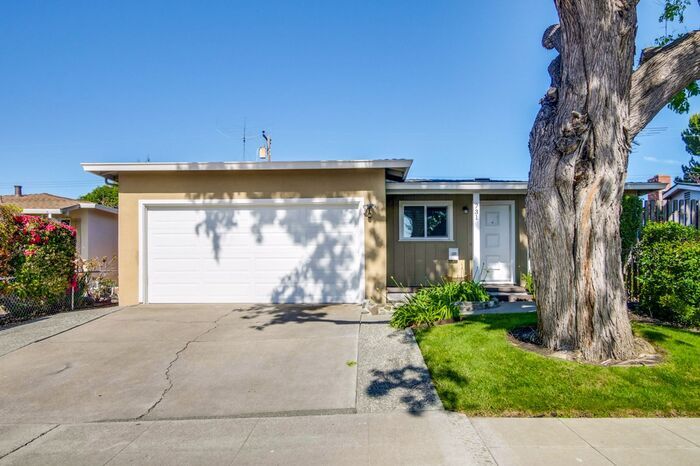
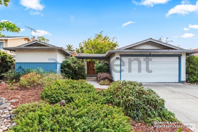
731 Santa Paula Ave
Sunnyvale, CA 94085
2 Weeks Ago
Favorites
731 Santa Paula Ave

Favorites
Check Back Soon for Upcoming Availability
| Beds | Baths | Average SF |
|---|---|---|
| 4 Bedrooms 4 Bedrooms 4 Br | 2.5 Baths 2.5 Baths 2.5 Ba | 1,442 SF |
About This Property
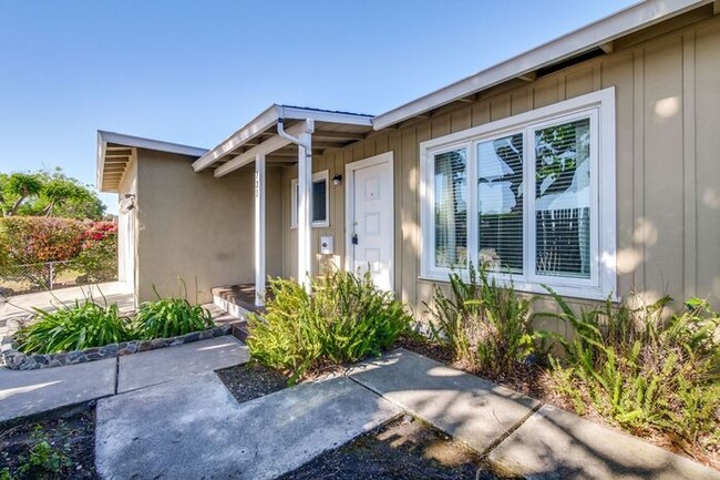
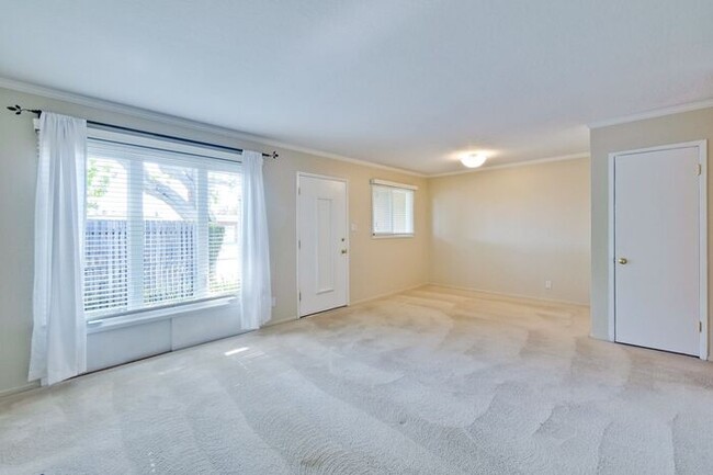
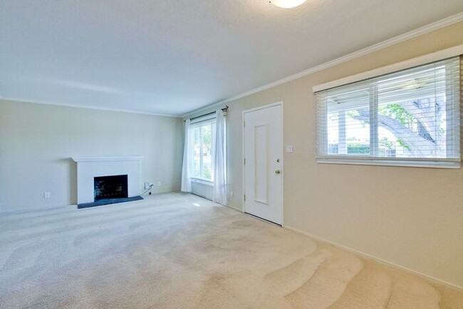
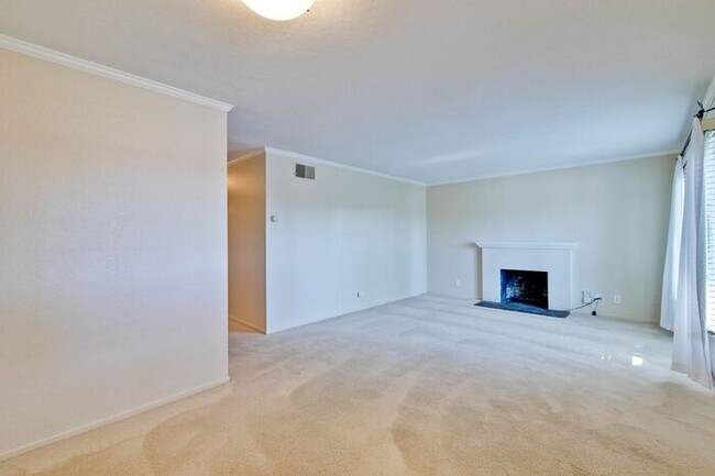
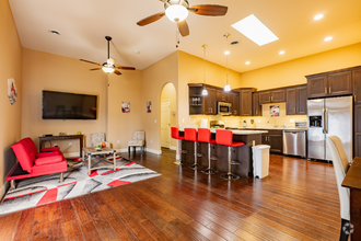
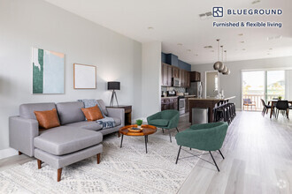
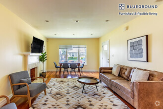
Lovely mature gardens surround this ranch-style home in a family-friendly neighborhood. Enter the inviting living/dining room combination that includes a fireplace. Updated kitchen with built-in appliances, microwave, fridge, dishwasher and Gas Stove. Cheerful utility room with half bath. Central Heating The spacious master suite with dual closets and easy access to the backyard. Additional Walk in Closet. There is an attached two-car garage with a workbench. Centrally located to Apple, Google, and LinkedIn headquarters. Great commuter location within minutes from Highways 101 and 237 Service animals only. Service animals only Apply online at lpmsiliconvalley.com This home is a must-see call today to schedule a tour. Call, text, or email Eve at 650-575-2274 or Eve@baylpg.com Rental Terms: Rent: $3,900, Application Fee: $50, Security Deposit: $3,900, Available Now Pet Policy: Cats not allowed, Dogs not allowed Contact us to schedule a showing.
731 Santa Paula Ave is a house located in Santa Clara County and the 94085 ZIP Code. This area is served by the Sunnyvale attendance zone.
Location
Get Directions
Sunnyvale’s San Miguel neighborhood is a residential community located near the intersection of the Bayshore Freeway and Lawrence Expressway. San Miguel offers residents a variety of options to try international cuisine with presence of the Taj Mahal Fresh Market, Pho Vy Vietnamese, Clarita’s Filipino Cuisine, Barn Thai, Tia Juana Mexican Grill, and Tres Potrillos Taqueria.
Neighboring parks such as Fair Oaks Park, Lakewood Park, Seven Seas Park, and Columbia Park provide endless opportunities for outdoor recreation. Major attractions like Levi’s Stadium, Intel Museum, and California’s Great America are all within a short drive from San Miguel too.
Convenient to multiple bus routes in addition to the Bayshore Freeway and Lawrence Expressway, commuting from San Miguel is simple. Mineta San Jose International Airport is just minutes down the Bayshore Freeway from San Miguel, making for easy travels.
Learn more about living in San MiguelBelow are rent ranges for similar nearby apartments
Education
| Colleges & Universities | Distance | ||
|---|---|---|---|
| Colleges & Universities | Distance | ||
| Drive: | 10 min | 5.9 mi | |
| Drive: | 12 min | 6.7 mi | |
| Drive: | 12 min | 6.7 mi | |
| Drive: | 16 min | 10.1 mi |
731 Santa Paula Ave is within 10 minutes or 5.9 miles from Palmer College of Chiropractic West Campus. It is also near Santa Clara University and De Anza College.
Schools


Public Elementary School
Grades K-5
367 Students
Nearby
Public Elementary School
Grades K-5
385 Students
Attendance Zone
Public Middle School
Grades 6-8
587 Students
Attendance Zone
Public High School
Grades 9-12
2,171 Students
Attendance Zone
Private Elementary & Middle School
Grades PK-8
236 Students
Nearby
Private Elementary School
Grades PK-6
810 Students
Nearby
Private Middle & High School
Grades 6-12
937 Students
Nearby
School data provided by
 The GreatSchools Rating helps parents compare schools within a state based on a variety of school quality indicators and provides a helpful picture of how effectively each school serves all of its students. Ratings are on a scale of 1 (below average) to 10 (above average) and can include test scores, college readiness, academic progress, advanced courses, equity, discipline and attendance data. We also advise parents to visit schools, consider other information on school performance and programs, and consider family needs as part of the school selection process.
View GreatSchools Rating Methodology
View GreatSchools Rating Methodology
Transportation options available in Sunnyvale include Fair Oaks Station, located 1.5 miles from 731 Santa Paula Ave. 731 Santa Paula Ave is near Norman Y Mineta San Jose International, located 5.6 miles or 10 minutes away, and San Francisco International, located 28.6 miles or 36 minutes away.
| Transit / Subway | Distance | ||
|---|---|---|---|
| Transit / Subway | Distance | ||
|
|
Drive: | 4 min | 1.5 mi |
|
|
Drive: | 4 min | 1.8 mi |
|
|
Drive: | 4 min | 2.0 mi |
|
|
Drive: | 5 min | 2.3 mi |
| Drive: | 5 min | 2.6 mi |
| Commuter Rail | Distance | ||
|---|---|---|---|
| Commuter Rail | Distance | ||
| Drive: | 4 min | 2.0 mi | |
| Drive: | 6 min | 2.2 mi | |
| Drive: | 9 min | 4.7 mi | |
| Drive: | 11 min | 5.5 mi | |
| Drive: | 11 min | 6.4 mi |
| Airports | Distance | ||
|---|---|---|---|
| Airports | Distance | ||
|
Norman Y Mineta San Jose International
|
Drive: | 10 min | 5.6 mi |
|
San Francisco International
|
Drive: | 36 min | 28.6 mi |
Time and distance from 731 Santa Paula Ave.
| Shopping Centers | Distance | ||
|---|---|---|---|
| Shopping Centers | Distance | ||
| Walk: | 6 min | 0.3 mi | |
| Walk: | 15 min | 0.8 mi | |
| Walk: | 19 min | 1.0 mi |
731 Santa Paula Ave has 3 shopping centers within 1.0 miles, which is about a 19-minute walk. The miles and minutes will be for the farthest away property.
| Parks and Recreation | Distance | ||
|---|---|---|---|
| Parks and Recreation | Distance | ||
|
Sunnyvale Baylands Park
|
Drive: | 7 min | 3.0 mi |
|
Ulistac Natural Area
|
Drive: | 9 min | 4.4 mi |
|
Live Oak Park - Santa Clara
|
Drive: | 8 min | 4.5 mi |
|
Alviso Marina County Park
|
Drive: | 9 min | 5.6 mi |
|
Stevens Creek Shoreline Nature Study Area
|
Drive: | 12 min | 6.5 mi |
731 Santa Paula Ave has 5 parks within 6.5 miles, including Sunnyvale Baylands Park, Ulistac Natural Area, and Live Oak Park - Santa Clara.
| Hospitals | Distance | ||
|---|---|---|---|
| Hospitals | Distance | ||
| Drive: | 7 min | 4.3 mi | |
| Drive: | 8 min | 4.5 mi | |
| Drive: | 10 min | 6.0 mi |
731 Santa Paula Ave has 3 hospitals within 6.0 miles, the nearest is Kaiser Foundation Hospital - Santa Clara which is 4.3 miles away and a 7 minute drive.
| Military Bases | Distance | ||
|---|---|---|---|
| Military Bases | Distance | ||
| Drive: | 11 min | 5.3 mi |
731 Santa Paula Ave is 5.3 miles and a 11 minute drive from Ames Research Center.
You May Also Like
Similar Rentals Nearby

What Are Walk Score®, Transit Score®, and Bike Score® Ratings?
Walk Score® measures the walkability of any address. Transit Score® measures access to public transit. Bike Score® measures the bikeability of any address.
What is a Sound Score Rating?
A Sound Score Rating aggregates noise caused by vehicle traffic, airplane traffic and local sources

731 Santa Paula Ave
Sunnyvale, CA 94085