
$3,200 / Month
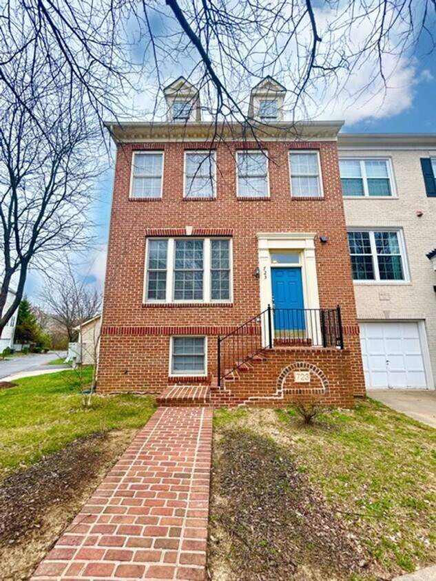
723 Rolling Fields Way
Rockville, MD 20850
2 Weeks Ago
Favorites
723 Rolling Fields Way

Favorites
Check Back Soon for Upcoming Availability
| Beds | Baths | Average SF |
|---|---|---|
| 3 Bedrooms 3 Bedrooms 3 Br | 2.5 Baths 2.5 Baths 2.5 Ba | 1,792 SF |
About This Property
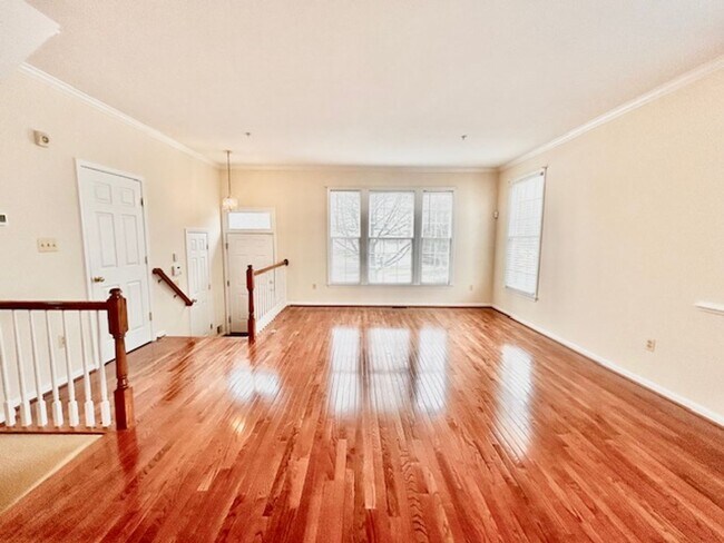
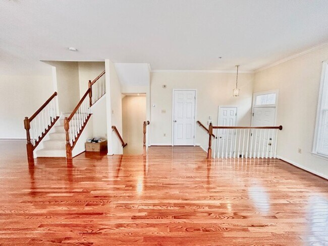
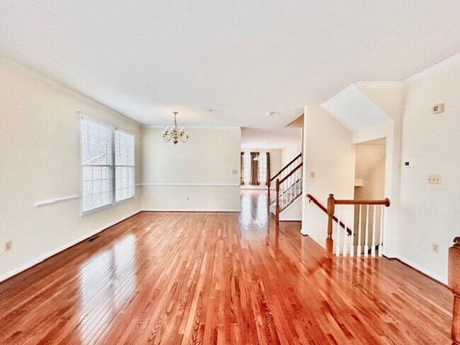
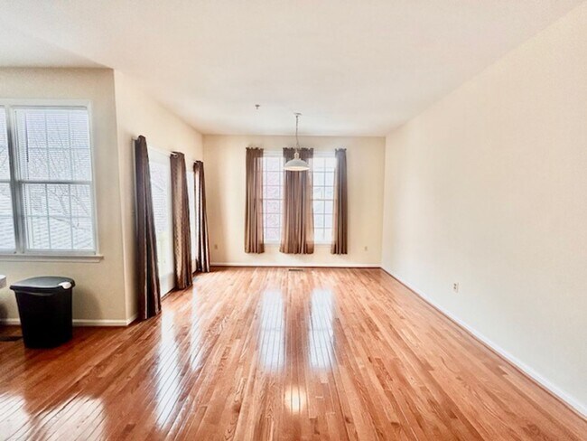
Large immaculate 3 level end unit townhome with expanded master bedroom, semi-finished walk-out basement, large storage room, and one car detached garage. Hardwood flooring on main and 2nd levels. Luxury vinyl plank in the semi-finished basement. Easy access to Shady Grove Metro, free shuttle bus or walk. Very close to shopping & restaurants. Features include: 3 Bedrooms 2.5 baths Square feet: 2192 sft Above grade finished area : 1792 sft Below grade finished area (approx.): 400 sft Below grade, unfinished area (approx.): 496 sft Hardwood on main and 2 nd levels Luxury vinyl plank in the finished basement New carpet on staircase steps Close to Shady Grove metro King Farm shuttle service to metro King Farm community pool and gym Requirements: Credit score: 700+ Income: 3 times rent No negative rental history All applicants 18+ MUST apply **ATTENTION**: We do not ask people to submit rental applications in order to see properties. Do not submit applications on systems that we do not authorize. Beware of scams!
723 Rolling Fields Way is a house located in Montgomery County and the 20850 ZIP Code. This area is served by the Montgomery County Public Schools attendance zone.
Location
Get Directions
West Rockville is a thriving neighborhood in the city of Rockville just 20 miles from Washington DC. Interstate 270 and Hungerford Drive make traveling to surrounding areas easy. West Rockville is a mostly residential area with a variety of apartment styles in average DC metro price ranges scattered throughout. While homes and green spaces such as Wootton’s Mill Park make up most of the neighborhood, department stores, eateries, grocers, and other businesses can be found situated towards the edges of town along the main roads.
Rockville Town Square, an area full of restaurants and specialty shops, is the hub of entertainment in Rockville and is located right outside West Rockville’s southern border. Outside of its norther border is Adventist Healthcare Shady Grove Medical Center, a large hospital complex. Other amenities in proximity to West Rockville include shopping centers and scenic parks and preservation land.
Learn more about living in West RockvilleBelow are rent ranges for similar nearby apartments
| Beds | Average Size | Lowest | Typical | Premium |
|---|---|---|---|---|
| Studio Studio Studio | 486-488 Sq Ft | $1,511 | $1,993 | $2,882 |
| 1 Bed 1 Bed 1 Bed | 735-743 Sq Ft | $1,575 | $2,115 | $3,337 |
| 2 Beds 2 Beds 2 Beds | 1125-1130 Sq Ft | $2,035 | $2,830 | $4,421 |
| 3 Beds 3 Beds 3 Beds | 1726 Sq Ft | $2,559 | $3,336 | $4,595 |
| 4 Beds 4 Beds 4 Beds | 2899 Sq Ft | $2,757 | $4,314 | $5,600 |
Education
| Colleges & Universities | Distance | ||
|---|---|---|---|
| Colleges & Universities | Distance | ||
| Drive: | 5 min | 2.3 mi | |
| Drive: | 7 min | 2.8 mi | |
| Drive: | 14 min | 8.5 mi | |
| Drive: | 25 min | 15.5 mi |
723 Rolling Fields Way is within 5 minutes or 2.3 miles from Montgomery College, Rockville. It is also near Universities at Shady Grove and Montgomery College.
Schools


Public Elementary School
Grades PK-5
471 Students
Attendance Zone
Public Middle School
Grades 6-8
1,325 Students
Attendance Zone
Public High School
Grades 9-12
2,390 Students
Attendance Zone
Private Elementary, Middle & High School
Grades PK-12
163 Students
Nearby
Private Elementary, Middle & High School
Grades 3-11
2 Students
Nearby
Private Elementary, Middle & High School
Grades 5-12
25 Students
Nearby
School data provided by
 The GreatSchools Rating helps parents compare schools within a state based on a variety of school quality indicators and provides a helpful picture of how effectively each school serves all of its students. Ratings are on a scale of 1 (below average) to 10 (above average) and can include test scores, college readiness, academic progress, advanced courses, equity, discipline and attendance data. We also advise parents to visit schools, consider other information on school performance and programs, and consider family needs as part of the school selection process.
View GreatSchools Rating Methodology
Data provided by GreatSchools.org © 2025. All rights reserved.
View GreatSchools Rating Methodology
Data provided by GreatSchools.org © 2025. All rights reserved.
Transportation options available in Rockville include Shady Grove, located 0.8 mile from 723 Rolling Fields Way. 723 Rolling Fields Way is near Ronald Reagan Washington Ntl, located 23.4 miles or 42 minutes away, and Washington Dulles International, located 29.8 miles or 47 minutes away.
| Transit / Subway | Distance | ||
|---|---|---|---|
| Transit / Subway | Distance | ||
| Walk: | 15 min | 0.8 mi | |
| Drive: | 7 min | 3.1 mi | |
| Drive: | 12 min | 5.2 mi | |
| Drive: | 14 min | 6.2 mi | |
| Drive: | 17 min | 7.5 mi |
| Commuter Rail | Distance | ||
|---|---|---|---|
| Commuter Rail | Distance | ||
|
|
Drive: | 5 min | 2.4 mi |
| Drive: | 6 min | 2.9 mi | |
| Drive: | 6 min | 2.9 mi | |
|
|
Drive: | 6 min | 2.9 mi |
|
|
Drive: | 7 min | 3.1 mi |
| Airports | Distance | ||
|---|---|---|---|
| Airports | Distance | ||
|
Ronald Reagan Washington Ntl
|
Drive: | 42 min | 23.4 mi |
|
Washington Dulles International
|
Drive: | 47 min | 29.8 mi |
Time and distance from 723 Rolling Fields Way.
| Shopping Centers | Distance | ||
|---|---|---|---|
| Shopping Centers | Distance | ||
| Walk: | 3 min | 0.2 mi | |
| Drive: | 3 min | 1.3 mi | |
| Drive: | 3 min | 1.3 mi |
723 Rolling Fields Way has 3 shopping centers within 1.3 miles, which is about a 3-minute walk. The miles and minutes will be for the farthest away property.
| Parks and Recreation | Distance | ||
|---|---|---|---|
| Parks and Recreation | Distance | ||
|
Croydon Creek Nature Center
|
Drive: | 11 min | 4.6 mi |
|
Agricultural History Farm Park
|
Drive: | 12 min | 4.8 mi |
|
Meadowside Nature Center
|
Drive: | 12 min | 5.3 mi |
|
Hunters Woods Park
|
Drive: | 12 min | 6.0 mi |
|
Seneca Creek State Park
|
Drive: | 12 min | 6.4 mi |
723 Rolling Fields Way has 5 parks within 6.4 miles, including Croydon Creek Nature Center, Agricultural History Farm Park, and Meadowside Nature Center.
| Hospitals | Distance | ||
|---|---|---|---|
| Hospitals | Distance | ||
| Drive: | 6 min | 2.5 mi | |
| Drive: | 11 min | 7.3 mi | |
| Drive: | 19 min | 11.2 mi |
723 Rolling Fields Way has 3 hospitals within 11.2 miles, the nearest is Adventist Healthcare Shady Grove Medical Center which is 2.5 miles away and a 6 minute drive.
You May Also Like
Similar Rentals Nearby


What Are Walk Score®, Transit Score®, and Bike Score® Ratings?
Walk Score® measures the walkability of any address. Transit Score® measures access to public transit. Bike Score® measures the bikeability of any address.
What is a Sound Score Rating?
A Sound Score Rating aggregates noise caused by vehicle traffic, airplane traffic and local sources

723 Rolling Fields Way
Rockville, MD 20850