$2,800
/ Month
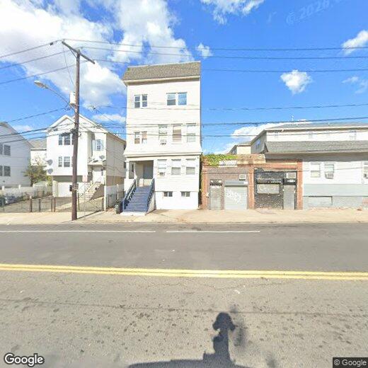
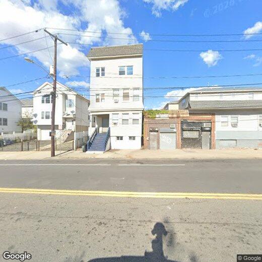
71 W Runyon St
Newark, NJ 07108
2 Weeks Ago
|
Edit
Favorites
71 W Runyon St

Favorites
Check Back Soon for Upcoming Availability
| Beds | Baths | Average SF |
|---|---|---|
| 4 Bedrooms 4 Bedrooms 4 Br | 1 Bath 1 Bath 1 Ba | — |
About This Property
WELCOME TO 71 W. RUNYON ST, 4 BEDROOM 2 BATH UNIT, FULLY RENOVATED LOCATED IN PRIME LOCATION OF NEWARK NJ, NEAR ALL MAJOR HIGHWAYS AND PUBLIC TRANSPORTATION. ALL BEDROOMS ARE SPACIOUS AND HAVE CLOSETS.
71 W Runyon St is an apartment community located in Essex County and the 07108 ZIP Code.
71 W Runyon St,
Newark,
NJ
07108
The South Broad Street neighborhood sits just south of Downtown Newark. This area is very walkable and accessible to public transportation, making it easy to get around the city. Many apartments and condos for rent sit within walking distance of Lincoln Park, where locals gather for events such as the popular Lincoln Park Music Festival, a community celebration of music, food, and culture that features live gospel, hip hop, and jazz. The New Jersey Institute of Technology, Newark Museum of Art, and Rutgers University Newark Campus sit nearby, so there are plenty of options for further education and entertainment around South Broad Street.
Learn more about living in South Broad StreetBelow are rent ranges for similar nearby apartments
Education
| Colleges & Universities | Distance | ||
|---|---|---|---|
| Colleges & Universities | Distance | ||
| Drive: | 4 min | 2.2 mi | |
| Drive: | 5 min | 2.4 mi | |
| Drive: | 5 min | 2.7 mi | |
| Drive: | 9 min | 4.3 mi |
71 W Runyon St is within 4 minutes or 2.2 miles from Essex County College. It is also near N.J. Inst. of Technology and Rutgers, Newark Campus.
Transportation options available in Newark include Warren Street, located 2.2 miles from 71 W Runyon St. 71 W Runyon St is near Newark Liberty International, located 4.1 miles or 6 minutes away, and LaGuardia, located 23.4 miles or 40 minutes away.
| Transit / Subway | Distance | ||
|---|---|---|---|
| Transit / Subway | Distance | ||
|
|
Drive: | 4 min | 2.2 mi |
|
|
Drive: | 5 min | 2.3 mi |
|
|
Drive: | 4 min | 2.3 mi |
|
|
Drive: | 5 min | 2.4 mi |
|
|
Drive: | 6 min | 3.3 mi |
| Commuter Rail | Distance | ||
|---|---|---|---|
| Commuter Rail | Distance | ||
|
|
Drive: | 8 min | 2.6 mi |
|
|
Drive: | 8 min | 2.6 mi |
|
|
Drive: | 5 min | 2.8 mi |
|
|
Drive: | 6 min | 3.0 mi |
|
|
Drive: | 9 min | 3.4 mi |
| Airports | Distance | ||
|---|---|---|---|
| Airports | Distance | ||
|
Newark Liberty International
|
Drive: | 6 min | 4.1 mi |
|
LaGuardia
|
Drive: | 40 min | 23.4 mi |
Walkability Near 71 W Runyon St Newark, NJ 07108
Getting Around
 What do Walkability, Transit, Drivability, and Bikeability mean?
Walkability measures the walking distance to day-to-day needs.
Transit measures access to public transportation.
Drivability measures congestion, parking availability, and access to major roads.
Bikeability measures the suitability for cycling.
How It Works
What do Walkability, Transit, Drivability, and Bikeability mean?
Walkability measures the walking distance to day-to-day needs.
Transit measures access to public transportation.
Drivability measures congestion, parking availability, and access to major roads.
Bikeability measures the suitability for cycling.
How It Works
Very Walkable
Walkability
80
/ 100
Strong Public Transit
Transit
80
/ 100
Moderately Drivable
Drivability
70
/ 100
Fairly Bikeable
Bikeability
50
/ 100
Scores provided by
Busy
Soundscore™
63
/ 100
Traffic
BusyAirport
BusyBusinesses
BusyScores provided by
HowLoud What is a Sound Score Rating? A Sound Score Rating aggregates noise caused by vehicle traffic, airplane traffic and local sources. How It WorksTime and distance from 71 W Runyon St.
| Shopping Centers | Distance | ||
|---|---|---|---|
| Shopping Centers | Distance | ||
| Walk: | 17 min | 0.9 mi | |
| Drive: | 3 min | 1.6 mi | |
| Drive: | 4 min | 1.7 mi |
71 W Runyon St has 3 shopping centers within 1.7 miles, which is about a 4-minute drive. The miles and minutes will be for the farthest away property.
| Parks and Recreation | Distance | ||
|---|---|---|---|
| Parks and Recreation | Distance | ||
|
Newark Museum and Dreyfuss Planetarium
|
Drive: | 5 min | 2.6 mi |
|
Branch Brook Park
|
Drive: | 9 min | 4.1 mi |
|
Kearny Marsh
|
Drive: | 12 min | 5.6 mi |
|
Stephen Gregg Park
|
Drive: | 12 min | 7.5 mi |
|
G. Thomas DiDomenico Park
|
Drive: | 15 min | 9.0 mi |
71 W Runyon St has 5 parks within 9.0 miles, including Newark Museum and Dreyfuss Planetarium, Branch Brook Park, and Kearny Marsh.
| Hospitals | Distance | ||
|---|---|---|---|
| Hospitals | Distance | ||
| Drive: | 2 min | 1.4 mi | |
| Drive: | 3 min | 2.0 mi | |
| Drive: | 5 min | 2.7 mi |
71 W Runyon St has 3 hospitals within 2.7 miles, the nearest is Newark Beth Israel Medical Center which is 1.4 miles away and a 2 minute drive.
| Military Bases | Distance | ||
|---|---|---|---|
| Military Bases | Distance | ||
| Drive: | 11 min | 7.9 mi | |
| Drive: | 24 min | 15.5 mi | |
| Drive: | 29 min | 16.2 mi |
71 W Runyon St has 3 military bases within 16.2 miles, the nearest is Military Ocean Terminal which is 7.9 miles away and a 11 minute drive.
You May Also Like
How do I access Social Services in New Jersey?
Statewide service is free, confidential, multilingual and always open. Three easy ways to reach Social Services in NJ: Dial 2-1-1; text your zip code to 898-211; or chat at https://www.nj211.org
Similar Rentals Nearby


What Are Walk Score®, Transit Score®, and Bike Score® Ratings?
Walk Score® measures the walkability of any address. Transit Score® measures access to public transit. Bike Score® measures the bikeability of any address.
What is a Sound Score Rating?
A Sound Score Rating aggregates noise caused by vehicle traffic, airplane traffic and local sources.
71 W Runyon St
Newark, NJ 07108