

$2,795 / Month
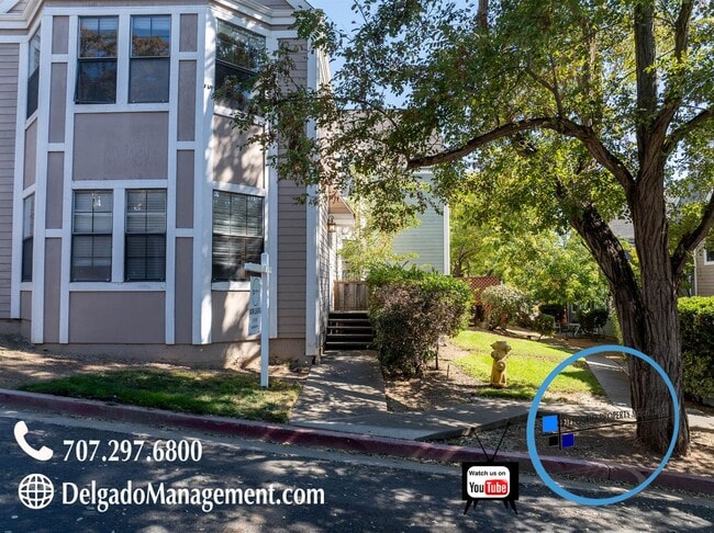
703 Military E
Benicia, CA 94510
2 Weeks Ago
Favorites
-
Bedrooms
2
-
Bathrooms
2
-
Square Feet
--
703 Military E

Favorites
About This Home
$2,795 deposit
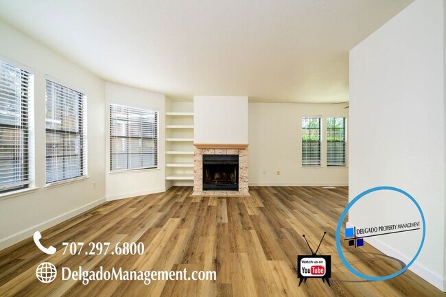
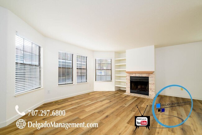
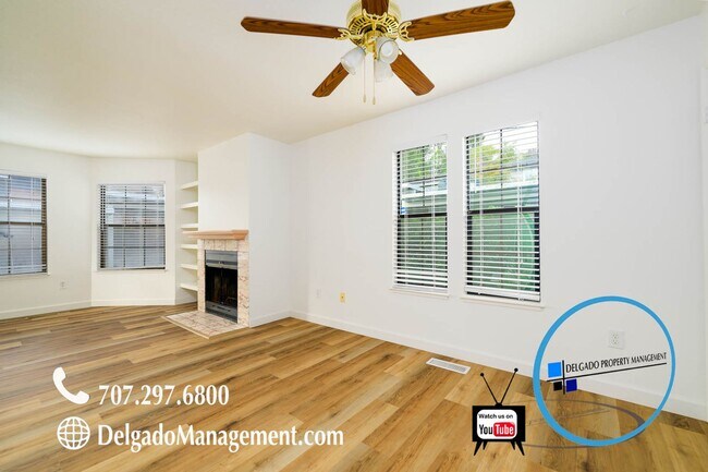
Benicia! Beautiful large townhouse located near downtown Benicia available now. This gorgeous townhome comes with lots of room, two large bedrooms, two full baths, half a bath downstairs, large kitchen with all appliances are included. Inside laundry hook ups, private patio, one covered assigned parking spot, and one open assigned parking spot. Rent price includes water, trash and sewer. Only minutes from First Street where you can enjoy One House Bakery, Rrags Caffe Shop, The Loft Wine Bar, Palermos Italian Restaurant, Izaka Sushi, Benicia Antique Shop, Daughter of Luna Flower Shop, and so many more shops and restaurants you can enjoy. This location is hard to resist especially if you enjoy beautiful sunsets by the water! Pets are welcome! Breed and weight restrictions apply. - Lease Duration 12 months - Must make 3 times the rent as income - $40 Application fee per adult - 2 Years of employment and rental history - Must carry renters insurance throughout tenancy - 650 or above credit score is required - Please submit your applications through Delgado Property Management website - We do not accept Zillow rental applications or any third party applications.
703 Military E is a house located in Solano County and the 94510 ZIP Code. This area is served by the Benicia Unified attendance zone.
* Price shown is base rent and may not include non-optional fees and utilities.
Price, availability, fees, and any applicable rent special are subject to change without notice.
* Square footage definitions vary. Displayed square footage is approximate.
Location
Get Directions
Situated along the Carquinez Strait in the San Francisco Bay Area, Benicia is a scenic waterfront city rich in history, cultural amenities, and sweeping vistas. Benicia boasts an irresistible historic charm, especially in its quaint downtown area, which is brimming with one-of-a-kind shops, delectable eateries, and vibrant artists’ studios.
Founded in 1847, Benicia once served as California’s state capital for 13 months, and now touts the only state capitol building outside of Sacramento. Residents and visitors alike can uncover much of Benicia’s past at the Benicia Historical Museum.
Nearly 500 acres of parkland provides ample green space and tranquil trails for all kinds of outdoor recreation. Benicia’s thriving arts community creates a broad range of art, from glass art and sculptures to theatrical plays and music. Benicia’s friendly community comes together for a variety of events, like the Downtown Farmers Market, Opening Day on the Strait, and artist studio open houses.
Learn more about living in Benicia
Education
| Colleges & Universities | Distance | ||
|---|---|---|---|
| Colleges & Universities | Distance | ||
| Drive: | 14 min | 9.2 mi | |
| Drive: | 20 min | 11.8 mi | |
| Drive: | 22 min | 15.9 mi | |
| Drive: | 24 min | 18.1 mi |
703 Military E is within 14 minutes or 9.2 miles from Diablo Valley, Pleasant Hill. It is also near Touro University California and Solano Community College.
Schools


Public Elementary School
Grades K-5
440 Students
Nearby
Public Elementary School
Grades K-5
444 Students
Attendance Zone
Public Middle School
Grades 6-8
986 Students
Attendance Zone
Public High School
Grades 9-12
1,432 Students
Attendance Zone
Private Elementary School
Grades PK-5
78 Students
Nearby
Private Elementary, Middle & High School
Grades 3-12
7 Students
Nearby
Private Elementary & Middle School
Grades PK-8
330 Students
Nearby
School data provided by
 The GreatSchools Rating helps parents compare schools within a state based on a variety of school quality indicators and provides a helpful picture of how effectively each school serves all of its students. Ratings are on a scale of 1 (below average) to 10 (above average) and can include test scores, college readiness, academic progress, advanced courses, equity, discipline and attendance data. We also advise parents to visit schools, consider other information on school performance and programs, and consider family needs as part of the school selection process.
View GreatSchools Rating Methodology
Data provided by GreatSchools.org © 2025. All rights reserved.
View GreatSchools Rating Methodology
Data provided by GreatSchools.org © 2025. All rights reserved.
Transportation options available in Benicia include North Concord Martinez Station, located 10.3 miles from 703 Military E. 703 Military E is near Metro Oakland International, located 36.6 miles or 48 minutes away, and San Francisco International, located 47.8 miles or 64 minutes away.
| Transit / Subway | Distance | ||
|---|---|---|---|
| Transit / Subway | Distance | ||
|
|
Drive: | 15 min | 10.3 mi |
|
|
Drive: | 15 min | 10.3 mi |
|
|
Drive: | 16 min | 10.8 mi |
|
|
Drive: | 16 min | 12.1 mi |
| Commuter Rail | Distance | ||
|---|---|---|---|
| Commuter Rail | Distance | ||
|
|
Drive: | 8 min | 5.3 mi |
|
|
Drive: | 26 min | 19.9 mi |
| Drive: | 29 min | 21.6 mi | |
|
|
Drive: | 32 min | 25.8 mi |
|
|
Drive: | 35 min | 27.6 mi |
| Airports | Distance | ||
|---|---|---|---|
| Airports | Distance | ||
|
Metro Oakland International
|
Drive: | 48 min | 36.6 mi |
|
San Francisco International
|
Drive: | 64 min | 47.8 mi |
Time and distance from 703 Military E.
| Shopping Centers | Distance | ||
|---|---|---|---|
| Shopping Centers | Distance | ||
| Walk: | 10 min | 0.5 mi | |
| Walk: | 15 min | 0.8 mi | |
| Walk: | 17 min | 0.9 mi |
703 Military E has 3 shopping centers within 0.9 mile, which is about a 17-minute walk. The miles and minutes will be for the farthest away property.
| Parks and Recreation | Distance | ||
|---|---|---|---|
| Parks and Recreation | Distance | ||
|
Benicia Capitol State Historic Park
|
Drive: | 2 min | 1.2 mi |
|
Waterbird Regional Preserve
|
Drive: | 6 min | 4.2 mi |
|
Martinez Regional Shoreline
|
Drive: | 10 min | 4.6 mi |
|
Alhambra Creek Watershed
|
Drive: | 8 min | 5.3 mi |
|
Carquinez Strait Regional Shoreline
|
Drive: | 19 min | 12.1 mi |
703 Military E has 5 parks within 12.1 miles, including Benicia Capitol State Historic Park, Waterbird Regional Preserve, and Martinez Regional Shoreline.
| Hospitals | Distance | ||
|---|---|---|---|
| Hospitals | Distance | ||
| Drive: | 10 min | 5.9 mi | |
| Drive: | 13 min | 8.7 mi | |
| Drive: | 14 min | 9.8 mi |
703 Military E has 3 hospitals within 9.8 miles, the nearest is Contra Costa Regional Medical Center which is 5.9 miles away and a 10 minute drive.
| Military Bases | Distance | ||
|---|---|---|---|
| Military Bases | Distance | ||
| Walk: | 16 min | 0.9 mi | |
| Drive: | 30 min | 13.0 mi |
703 Military E is 0.9 mile from Armory Vallejo, and is convenient to other military bases, including US Naval Station Port Chicago.
You May Also Like
Similar Rentals Nearby


What Are Walk Score®, Transit Score®, and Bike Score® Ratings?
Walk Score® measures the walkability of any address. Transit Score® measures access to public transit. Bike Score® measures the bikeability of any address.
What is a Sound Score Rating?
A Sound Score Rating aggregates noise caused by vehicle traffic, airplane traffic and local sources

703 Military E
Benicia, CA 94510