$1,950
/ Month
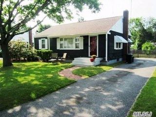
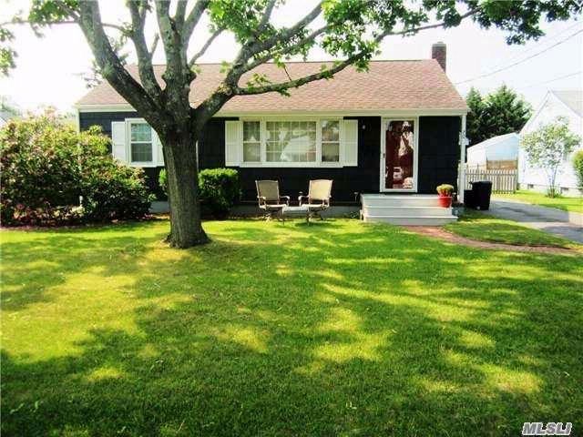
70 Terry Rd
Patchogue, NY 11772
2 Weeks Ago
|
Edit
Favorites
70 Terry Rd

Favorites
Check Back Soon for Upcoming Availability
| Beds | Baths | Average SF |
|---|---|---|
| 2 Bedrooms 2 Bedrooms 2 Br | 1 Bath 1 Bath 1 Ba | — |
About This Property
Immaculate 2 Bedroom Ranch With All The Comforts Of Home. (Listing 4988567 Confirmed 8/29/2017)
70 Terry Rd is a house located in Suffolk County and the 11772 ZIP Code.
70 Terry Rd,
Patchogue,
NY
11772
The Village of Patchogue sits on the south shoreline of Long Island in Suffolk County. Part of the town of Brookhaven, the community was incorporated in 1893, and is now home to a variety of fine dining establishments and breweries. Lombardi’s on the Bay is a popular spot to dine and has great water views.
The beautiful neighborhood, combined with a low cost of living and proximity to New York City, makes Patchogue an ideal place to live. You’ll love everything about your apartment – like how it’s close to Shorefront and Rider Avenue Parks.
Learn more about living in Patchogue
Education
| Colleges & Universities | Distance | ||
|---|---|---|---|
| Colleges & Universities | Distance | ||
| Drive: | 5 min | 2.0 mi | |
| Drive: | 14 min | 7.5 mi | |
| Drive: | 16 min | 10.9 mi | |
| Drive: | 22 min | 14.3 mi |
70 Terry Rd is within 5 minutes or 2.0 miles from St Joseph's Coll., Long Island. It is also near SUNY Suffolk Co., Ammerman and Touro University.
Walkability Near 70 Terry Rd Patchogue, NY 11772
Getting Around
 What do Walkability, Transit, Drivability, and Bikeability mean?
Walkability measures the walking distance to day-to-day needs.
Transit measures access to public transportation.
Drivability measures congestion, parking availability, and access to major roads.
Bikeability measures the suitability for cycling.
How It Works
What do Walkability, Transit, Drivability, and Bikeability mean?
Walkability measures the walking distance to day-to-day needs.
Transit measures access to public transportation.
Drivability measures congestion, parking availability, and access to major roads.
Bikeability measures the suitability for cycling.
How It Works
Fairly Walkable
Walkability
50
/ 100
Limited Public Transit
Transit
30
/ 100
Very Drivable
Drivability
80
/ 100
Somewhat Bikeable
Bikeability
30
/ 100
Scores provided by
-
Soundscore™
-
/ 100
Traffic
-Airport
-Businesses
-Scores provided by
HowLoud What is a Sound Score Rating? A Sound Score Rating aggregates noise caused by vehicle traffic, airplane traffic and local sources. How It WorksYou May Also Like
Similar Rentals Nearby
-

-

-
 3 Beds, 2 Baths, 1,200 sq ft$3,500Total Monthly PriceTotal Monthly Price NewPrices include all required monthly fees.215 E Lakewood St
 -
 2 Beds, 2 Baths, 918 sq ft$3,750Total Monthly PriceTotal Monthly Price NewPrices include all required monthly fees.109 Roosevelt Ave
 -
 3 Beds, 2 Baths, 1,152 sq ft$3,650Total Monthly PriceTotal Monthly Price NewPrices include all required monthly fees.12 Nord Park Blvd
 -
 4 Beds, 3 Baths, 2,222 sq ft$4,800Total Monthly PriceTotal Monthly Price NewPrices include all required monthly fees.3 Thornridge Ln
 -
 3 Beds, 1 Bath$3,200Total Monthly PriceTotal Monthly Price NewPrices include all required monthly fees.21 Sherwood Dr
 -
 4 Beds, 3 Baths, 2,337 sq ft$4,700Total Monthly PriceTotal Monthly Price NewPrices include all required monthly fees.15 Sherry Ln
 -
 3 Beds, 1 Bath, 1,526 sq ft$4,000Total Monthly PriceTotal Monthly Price NewPrices include all required monthly fees.20 Gabriel Mills Rd
 -
 4 Beds, 3 Baths, 2,376 sq ft$35,000Total Monthly PriceTotal Monthly Price NewPrices include all required monthly fees.19 Rogers Ln
What Are Walk Score®, Transit Score®, and Bike Score® Ratings?
Walk Score® measures the walkability of any address. Transit Score® measures access to public transit. Bike Score® measures the bikeability of any address.
What is a Sound Score Rating?
A Sound Score Rating aggregates noise caused by vehicle traffic, airplane traffic and local sources.

70 Terry Rd
Patchogue, NY 11772