

$4,200
/ Month
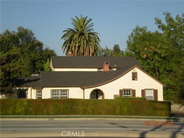
6958 N San Gabriel Blvd
San Gabriel, CA 91775
2 Weeks Ago
Favorites
6958 N San Gabriel Blvd

Favorites
Check Back Soon for Upcoming Availability
| Beds | Baths | Average SF |
|---|---|---|
| 3 Bedrooms 3 Bedrooms 3 Br | 2 Baths 2 Baths 2 Ba | 2,000 SF |
Fees and Policies
The fees below are based on community-supplied data and may exclude additional fees and utilities.
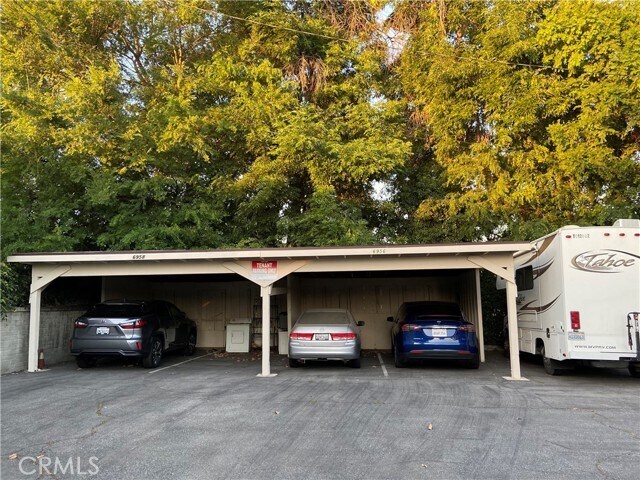
- Parking
-
Other--Assigned Parking
Details
Utilities Included
-
Water
-
Trash Removal
About This Property
This property is located in the San Marino School District with San Gabriel address. It is in the unincorporated LA county area. It is right next to Carver Elementary School and it is just across street from Trader Joe Plaza. Walking distance to San Marino High School. This is a duplex type building. 2 recently remodeled new bathrooms. There are two units in the building. The entrance of this unit is at the back of this building. Owner pay water, trash and gardening. No Sign on Property.
6958 N San Gabriel Blvd is a house located in Los Angeles County and the 91775 ZIP Code. This area is served by the San Marino Unified attendance zone.
House Features
Air Conditioning
Hardwood Floors
Fireplace
Window Coverings
- Air Conditioning
- Heating
- Fireplace
- Range
- Hardwood Floors
- Vinyl Flooring
- Dining Room
- Window Coverings
- Patio
Location
Get Directions
Situated about ten miles northeast of Los Angeles, San Gabriel is a scenic suburb often regarded as the “Birthplace of the Los Angeles Region.” The city boasts a rich history dating back to the 1700s, when the Mission San Gabriel (known as the “Pride of the California Missions”) was founded.
San Gabriel’s historic roots are on display to this day, with the vibrant Mission District serving as the city’s hub of culture, art, and history. City Hall, the San Gabriel Mission Playhouse, and numerous well-maintained Spanish Colonial Revival style buildings are the cornerstones of the District. A host of diverse eateries, cafes, offices, shops, and museums—including the famed San Gabriel Mission—are also found in this vibrant downtown area.
Area residents enjoy a bevy of outdoor activities at Vincent Lugo Park, Smith Park, and San Gabriel Country Club.
Learn more about living in San Gabriel
Amenities
- Air Conditioning
- Heating
- Fireplace
- Range
- Hardwood Floors
- Vinyl Flooring
- Dining Room
- Window Coverings
- Patio
Expenses
Utilities Included
Water, Trash Removal
Included
Education
| Colleges & Universities | Distance | ||
|---|---|---|---|
| Colleges & Universities | Distance | ||
| Drive: | 6 min | 2.5 mi | |
| Drive: | 7 min | 3.2 mi | |
| Drive: | 8 min | 4.2 mi | |
| Drive: | 10 min | 4.5 mi |
6958 N San Gabriel Blvd is within 6 minutes or 2.5 miles from Caltech. It is also near Pasadena City College and Fuller Theological Seminary.
Schools


Public Elementary School
Grades K-6
454 Students
Nearby
Public Elementary School
Grades K-5
641 Students
Attendance Zone
Public Middle School
Grades 6-8
627 Students
Attendance Zone
Public High School
Grades 9-12
806 Students
Attendance Zone
Private Elementary, Middle & High School
Grades K-12
Nearby
Private Elementary & Middle School
Grades K-8
178 Students
Nearby
School data provided by
 The GreatSchools Rating helps parents compare schools within a state based on a variety of school quality indicators and provides a helpful picture of how effectively each school serves all of its students. Ratings are on a scale of 1 (below average) to 10 (above average) and can include test scores, college readiness, academic progress, advanced courses, equity, discipline and attendance data. We also advise parents to visit schools, consider other information on school performance and programs, and consider family needs as part of the school selection process.
View GreatSchools Rating Methodology
Data provided by GreatSchools.org © 2025. All rights reserved.
View GreatSchools Rating Methodology
Data provided by GreatSchools.org © 2025. All rights reserved.
Transportation options available in San Gabriel include Sierra Madre Villa Station, located 3.6 miles from 6958 N San Gabriel Blvd. 6958 N San Gabriel Blvd is near Bob Hope, located 21.3 miles or 29 minutes away, and Long Beach (Daugherty Field), located 26.7 miles or 40 minutes away.
| Transit / Subway | Distance | ||
|---|---|---|---|
| Transit / Subway | Distance | ||
|
|
Drive: | 6 min | 3.6 mi |
|
|
Drive: | 7 min | 3.8 mi |
|
|
Drive: | 10 min | 4.0 mi |
|
|
Drive: | 10 min | 4.8 mi |
|
|
Drive: | 10 min | 5.8 mi |
| Commuter Rail | Distance | ||
|---|---|---|---|
| Commuter Rail | Distance | ||
|
|
Drive: | 13 min | 6.5 mi |
|
|
Drive: | 21 min | 10.1 mi |
|
|
Drive: | 20 min | 10.5 mi |
|
|
Drive: | 21 min | 12.0 mi |
| Drive: | 22 min | 15.8 mi |
| Airports | Distance | ||
|---|---|---|---|
| Airports | Distance | ||
|
Bob Hope
|
Drive: | 29 min | 21.3 mi |
|
Long Beach (Daugherty Field)
|
Drive: | 40 min | 26.7 mi |
Time and distance from 6958 N San Gabriel Blvd.
| Shopping Centers | Distance | ||
|---|---|---|---|
| Shopping Centers | Distance | ||
| Walk: | 2 min | 0.1 mi | |
| Drive: | 2 min | 1.2 mi | |
| Drive: | 3 min | 1.6 mi |
6958 N San Gabriel Blvd has 3 shopping centers within 1.6 miles, which is about a 3-minute walk. The miles and minutes will be for the farthest away property.
| Parks and Recreation | Distance | ||
|---|---|---|---|
| Parks and Recreation | Distance | ||
|
Huntington Botanical Gardens
|
Drive: | 6 min | 2.0 mi |
|
Los Angeles County Arboretum
|
Drive: | 6 min | 3.1 mi |
|
Eaton Canyon Nature Center
|
Drive: | 8 min | 4.0 mi |
|
Chilao Visitor Center
|
Drive: | 7 min | 4.8 mi |
|
Grassy Hollow Visitor Center
|
Drive: | 7 min | 4.8 mi |
6958 N San Gabriel Blvd has 5 parks within 4.8 miles, including Huntington Botanical Gardens, Los Angeles County Arboretum, and Eaton Canyon Nature Center.
| Hospitals | Distance | ||
|---|---|---|---|
| Hospitals | Distance | ||
| Drive: | 2 min | 1.3 mi | |
| Drive: | 5 min | 2.3 mi | |
| Drive: | 6 min | 3.4 mi |
6958 N San Gabriel Blvd has 3 hospitals within 3.4 miles, the nearest is Aurora Las Encinas Hospital which is 1.3 miles away and a 2 minute drive.
| Military Bases | Distance | ||
|---|---|---|---|
| Military Bases | Distance | ||
| Drive: | 41 min | 28.7 mi | |
| Drive: | 45 min | 30.3 mi |
6958 N San Gabriel Blvd is 28.7 miles from Los Angeles Air Force Base, and is convenient to other military bases, including Los Alamitos Army Airfield.
You May Also Like
Similar Rentals Nearby


What Are Walk Score®, Transit Score®, and Bike Score® Ratings?
Walk Score® measures the walkability of any address. Transit Score® measures access to public transit. Bike Score® measures the bikeability of any address.
What is a Sound Score Rating?
A Sound Score Rating aggregates noise caused by vehicle traffic, airplane traffic and local sources
6958 N San Gabriel Blvd
San Gabriel, CA 91775