
$1,995
/ Month
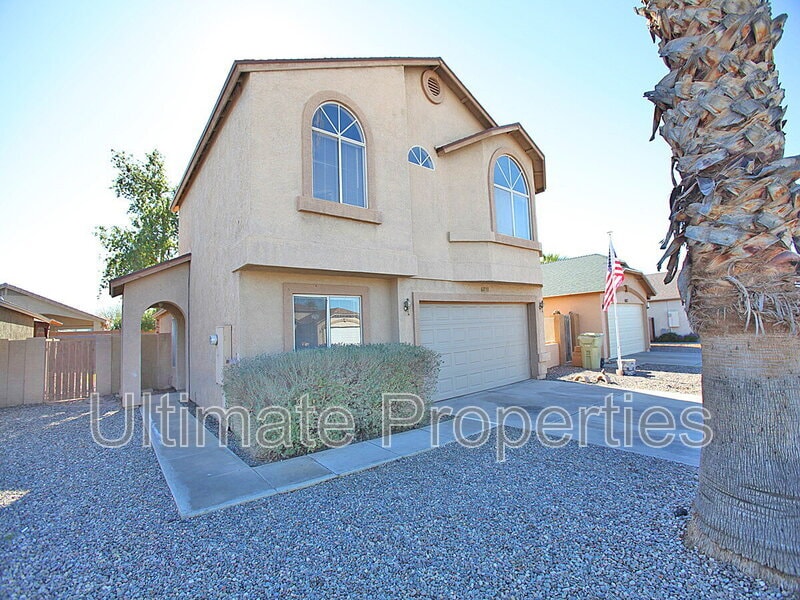
6853 W State Ave
Glendale, AZ 85303
Today
|
Edit
Favorites
623-263-9157
-
Bedrooms
4
-
Bathrooms
2.5
-
Square Feet
1,705 sq ft
-
Available
Available Feb 13
6853 W State Ave

Favorites
About This Home
$1,995 deposit,
Available Feb 13
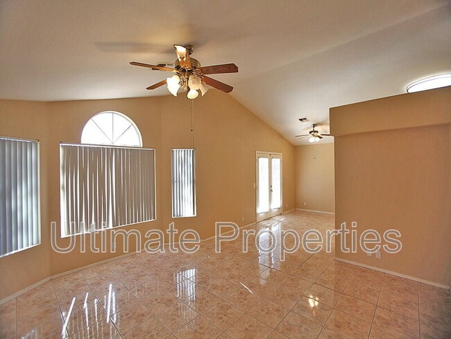
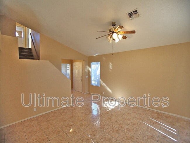
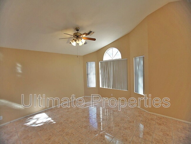
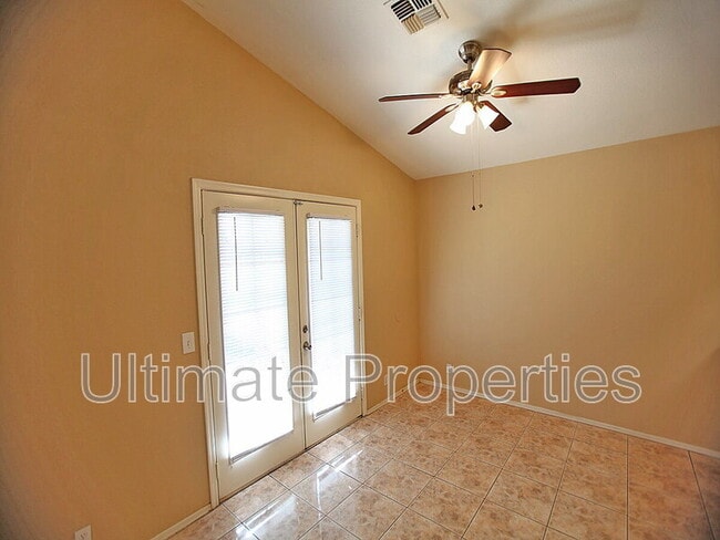
4 bedroom 2.5 bathroom house in Glendale. Kitchen features lots of cabinet space, stainless steel fridge, range/oven, microwave, white dishwasher. Ceiling fans and blinds throughout. Great open space, large living room and dining area. Master suite includes walk-in closet, dual sinks and tub/shower combo. Lots of storage. Tile and carpet throughout. Covered patio leads to a large backyard. Easy to maintain landscaping. 2 car garage Pet Details: All Pets Allowed
6853 W State Ave is a house located in Maricopa County and the 85303 ZIP Code. This area is served by the Glendale Elementary District attendance zone.
* Price shown is base rent. Excludes user-selected optional fees and variable or usage-based fees and required charges due at or prior to move-in or at move-out. Price, availability, fees, and any applicable rent special are subject to change without notice.
* Square footage definitions vary. Displayed square footage is approximate.
Fees and Policies
The fees below are based on community-supplied data and may exclude additional fees and utilities.
-
One-Time Basics
-
Due at Move-In
-
Security Deposit - RefundableCharged per unit.$1,995
-
-
Due at Move-In
-
Dogs
-
Allowed
-
-
Cats
-
Allowed
-
Property Fee Disclaimer: Based on community-supplied data and independent market research. Subject to change without notice. May exclude fees for mandatory or optional services and usage-based utilities.
Contact
- Phone Number
- Contact
Location
Get Directions
Westside is a neighborhood within Glendale, which was voted “Arizona’s Antique Capital” by Sunset magazine and USA Today. Many higher education schools are located near Westside, including Glendale Community College, Carrington College, and Arizona State University West campus. You’ll discover numerous pocket parks in the area, plus larger ones like Glendale Heroes Regional Park and Grand Canal Linear Park. Shopping and dining destinations are plentiful, especially at Arrowhead Towne Center Mall.
Learn more about living in Westside
Education
| Colleges & Universities | Distance | ||
|---|---|---|---|
| Colleges & Universities | Distance | ||
| Drive: | 7 min | 2.8 mi | |
| Drive: | 13 min | 5.9 mi | |
| Drive: | 15 min | 6.7 mi | |
| Drive: | 16 min | 7.4 mi |
6853 W State Ave is within 7 minutes or 2.8 miles from Glendale Community College. It is also near Grand Canyon University and Thunderbird, West Campus.
Schools


Public Elementary & Middle School
Grades PK-8
670 Students
Attendance Zone
Public High School
Grades 9-12
1,816 Students
Attendance Zone
Private Elementary, Middle & High School
Grades 5-12
Nearby
Private Elementary & Middle School
Grades PK-8
116 Students
Nearby
School data provided by
 The GreatSchools Rating helps parents compare schools within a state based on a variety of school quality indicators and provides a helpful picture of how effectively each school serves all of its students. Ratings are on a scale of 1 (below average) to 10 (above average) and can include test scores, college readiness, academic progress, advanced courses, equity, discipline and attendance data. We also advise parents to visit schools, consider other information on school performance and programs, and consider family needs as part of the school selection process.
View GreatSchools Rating Methodology
Data provided by GreatSchools.org © 2026. All rights reserved.
View GreatSchools Rating Methodology
Data provided by GreatSchools.org © 2026. All rights reserved.
Transportation options available in Glendale include Glendale/19Th Ave, located 6.7 miles from 6853 W State Ave. 6853 W State Ave is near Phoenix Sky Harbor International, located 16.6 miles or 29 minutes away.
| Transit / Subway | Distance | ||
|---|---|---|---|
| Transit / Subway | Distance | ||
|
|
Drive: | 15 min | 6.7 mi |
|
|
Drive: | 15 min | 7.2 mi |
|
|
Drive: | 15 min | 7.4 mi |
|
|
Drive: | 15 min | 7.5 mi |
|
|
Drive: | 16 min | 7.6 mi |
| Commuter Rail | Distance | ||
|---|---|---|---|
| Commuter Rail | Distance | ||
|
|
Drive: | 61 min | 44.4 mi |
| Airports | Distance | ||
|---|---|---|---|
| Airports | Distance | ||
|
Phoenix Sky Harbor International
|
Drive: | 29 min | 16.6 mi |
Time and distance from 6853 W State Ave.
| Shopping Centers | Distance | ||
|---|---|---|---|
| Shopping Centers | Distance | ||
| Walk: | 12 min | 0.6 mi | |
| Walk: | 14 min | 0.7 mi | |
| Walk: | 15 min | 0.8 mi |
6853 W State Ave has 3 shopping centers within 0.8 mile, which is about a 15-minute walk. The miles and minutes will be for the farthest away property.
| Parks and Recreation | Distance | ||
|---|---|---|---|
| Parks and Recreation | Distance | ||
|
El Oso Park
|
Drive: | 10 min | 4.7 mi |
|
Maryvale Park
|
Drive: | 11 min | 5.4 mi |
|
Acoma Park
|
Drive: | 17 min | 8.9 mi |
|
North Mountain Park
|
Drive: | 21 min | 10.7 mi |
|
Conocido Park
|
Drive: | 21 min | 11.4 mi |
6853 W State Ave has 5 parks within 11.4 miles, including El Oso Park, Maryvale Park, and Acoma Park.
| Hospitals | Distance | ||
|---|---|---|---|
| Hospitals | Distance | ||
| Drive: | 7 min | 3.6 mi | |
| Drive: | 12 min | 6.2 mi | |
| Drive: | 14 min | 7.3 mi |
6853 W State Ave has 3 hospitals within 7.3 miles, the nearest is Aurora Behavioral Health System which is 3.6 miles away and a 7 minute drive.
| Military Bases | Distance | ||
|---|---|---|---|
| Military Bases | Distance | ||
| Drive: | 17 min | 8.6 mi | |
| Drive: | 29 min | 16.4 mi | |
| Drive: | 98 min | 71.6 mi |
6853 W State Ave has 3 military bases within 71.6 miles, the nearest is Luke Air Force Base which is 8.6 miles away and a 17 minute drive.
You May Also Like
Similar Rentals Nearby


What Are Walk Score®, Transit Score®, and Bike Score® Ratings?
Walk Score® measures the walkability of any address. Transit Score® measures access to public transit. Bike Score® measures the bikeability of any address.
What is a Sound Score Rating?
A Sound Score Rating aggregates noise caused by vehicle traffic, airplane traffic and local sources
6853 W State Ave
Glendale, AZ 85303