

$2,700
/ Month
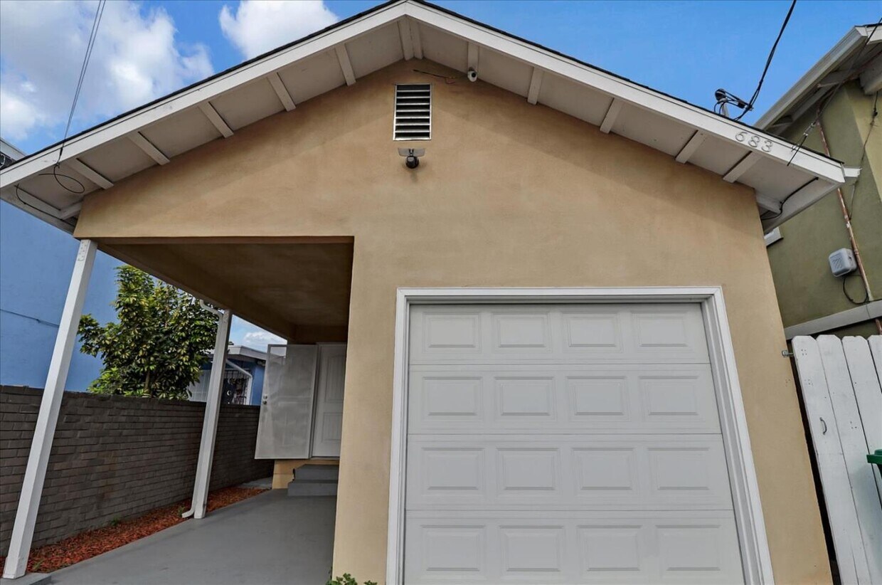
683 Harbour Way
Richmond, CA 94801
2 Weeks Ago
|
Edit
Favorites
683 Harbour Way

Favorites
Check Back Soon for Upcoming Availability
| Beds | Baths | Average SF |
|---|---|---|
| 3 Bedrooms 3 Bedrooms 3 Br | 1 Bath 1 Bath 1 Ba | 872 SF |
About This Property
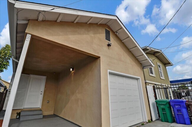
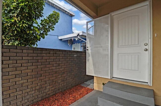
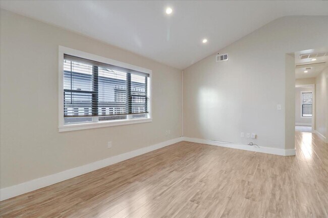
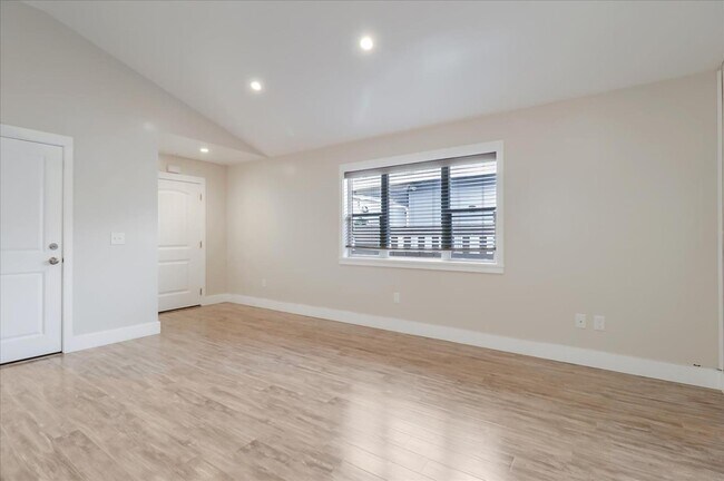
Beautiful 3-bedroom property in an ideal location, ready to be your new home! This sun-filled home welcomes you with its spacious open floor plan, hardwood floors, cathedral ceilings, and recessed lighting. A fenced rear garden awaits, perfect for play, al fresco brunches, and even a quick barbecue! A lovely shed is also available for you to use, either as storage or to be converted into a workshop. At the end of the day, three good-sized bedrooms finished in plush carpeting invite you to a good nights rest! A full kitchen with generous quartz countertops and ample cabinetry awaits, ready for your every meal. Conveniently plan and prepare your meals at home with stainless steel appliances ready to use. Washer and dryer and extra shelves are also installed for your laundry needs. Your new home is right in a location perfect for commuting to the city for work or entertainment. Close to BART, Kaiser Hospital, and shopping!
683 Harbour Way is a house located in Contra Costa County and the 94801 ZIP Code. This area is served by the West Contra Costa Unified attendance zone.
Location
Get Directions
The Iron Triangle neighborhood sits in the heart of Central Richmond, California. With the area being largely residential, most rentals reside in the upper part of the triangle and an easy three-mile commute north to Point Richmond, a major shipping and industrial area. To the south, Berkeley and Oakland lie roughly 10 miles away via Interstate 580.
Locals often head for the Miller/Knox Regional Shoreline for a bit of jogging or cycling, or to cast a line off the fishing pier. Wade into the waters of San Francisco Bay at Keller Beach on the northern end of the park, or enjoy a show at the Masquers Playhouse, also just outside the Iron Triangle's southern border. Most eateries sit along Interstate 580, including several fast food chains. The MacDonald 80 Shopping Center lies roughly three miles east of the neighborhood. Drive another three miles and find Wildcat Canyon Regional Park and the Tilden Nature Area.
Learn more about living in Iron TriangleBelow are rent ranges for similar nearby apartments
Education
| Colleges & Universities | Distance | ||
|---|---|---|---|
| Colleges & Universities | Distance | ||
| Drive: | 6 min | 2.8 mi | |
| Drive: | 16 min | 9.3 mi | |
| Drive: | 20 min | 10.4 mi | |
| Drive: | 19 min | 12.0 mi |
683 Harbour Way is within 6 minutes or 2.8 miles from Contra Costa College. It is also near Berkeley City College and UC Berkeley.
Schools


Public Elementary School
Grades K-5
270 Students
Nearby
Public Elementary & Middle School
Grades K-8
537 Students
Attendance Zone
Public Middle School
Grades 7-8
591 Students
Attendance Zone
Public High School
Grades 9-12
1,431 Students
Attendance Zone
Private Elementary, Middle & High School
Grades PK-12
Nearby
Private Elementary, Middle & High School
Grades K-12
Nearby
School data provided by
 The GreatSchools Rating helps parents compare schools within a state based on a variety of school quality indicators and provides a helpful picture of how effectively each school serves all of its students. Ratings are on a scale of 1 (below average) to 10 (above average) and can include test scores, college readiness, academic progress, advanced courses, equity, discipline and attendance data. We also advise parents to visit schools, consider other information on school performance and programs, and consider family needs as part of the school selection process.
View GreatSchools Rating Methodology
Data provided by GreatSchools.org © 2025. All rights reserved.
View GreatSchools Rating Methodology
Data provided by GreatSchools.org © 2025. All rights reserved.
Transportation options available in Richmond include Richmond Station, located 0.7 mile from 683 Harbour Way. 683 Harbour Way is near Metro Oakland International, located 22.4 miles or 31 minutes away, and San Francisco International, located 30.0 miles or 43 minutes away.
| Transit / Subway | Distance | ||
|---|---|---|---|
| Transit / Subway | Distance | ||
|
|
Walk: | 14 min | 0.7 mi |
|
|
Drive: | 6 min | 3.1 mi |
|
|
Drive: | 6 min | 3.1 mi |
|
|
Drive: | 9 min | 5.2 mi |
|
|
Drive: | 14 min | 8.7 mi |
| Commuter Rail | Distance | ||
|---|---|---|---|
| Commuter Rail | Distance | ||
| Walk: | 13 min | 0.7 mi | |
|
|
Drive: | 11 min | 8.0 mi |
|
|
Drive: | 14 min | 9.8 mi |
| Drive: | 17 min | 10.2 mi | |
| Drive: | 17 min | 11.1 mi |
| Airports | Distance | ||
|---|---|---|---|
| Airports | Distance | ||
|
Metro Oakland International
|
Drive: | 31 min | 22.4 mi |
|
San Francisco International
|
Drive: | 43 min | 30.0 mi |
Time and distance from 683 Harbour Way.
| Shopping Centers | Distance | ||
|---|---|---|---|
| Shopping Centers | Distance | ||
| Walk: | 12 min | 0.6 mi | |
| Drive: | 3 min | 1.4 mi | |
| Drive: | 4 min | 2.0 mi |
683 Harbour Way has 3 shopping centers within 2.0 miles, which is about a 4-minute drive. The miles and minutes will be for the farthest away property.
| Parks and Recreation | Distance | ||
|---|---|---|---|
| Parks and Recreation | Distance | ||
|
Rosie the Riveter WWII Home Front National Historical Park
|
Drive: | 5 min | 2.3 mi |
|
Marina Park & Green
|
Drive: | 5 min | 2.5 mi |
|
Miller/Knox Regional Shoreline
|
Drive: | 6 min | 2.9 mi |
|
Shimada Friendship Park
|
Drive: | 7 min | 3.2 mi |
|
Brooks Island Regional Preserve
|
Drive: | 10 min | 4.5 mi |
683 Harbour Way has 5 parks within 4.5 miles, including Rosie the Riveter WWII Home Front National Historical Park, Marina Park & Green, and Miller/Knox Regional Shoreline.
| Hospitals | Distance | ||
|---|---|---|---|
| Hospitals | Distance | ||
| Drive: | 18 min | 10.9 mi | |
| Drive: | 16 min | 11.9 mi | |
| Drive: | 16 min | 11.9 mi |
683 Harbour Way has 3 hospitals within 11.9 miles, the nearest is Alta Bates Summit Medical Center - Alta Bates Campus which is 10.9 miles away and a 18 minute drive.
| Military Bases | Distance | ||
|---|---|---|---|
| Military Bases | Distance | ||
| Drive: | 6 min | 2.9 mi | |
| Drive: | 12 min | 5.8 mi | |
| Drive: | 25 min | 16.0 mi |
683 Harbour Way has 3 military bases within 16.0 miles, the nearest is Armory West Contra Costa which is 2.9 miles away and a 6 minute drive.
You May Also Like
Similar Rentals Nearby


What Are Walk Score®, Transit Score®, and Bike Score® Ratings?
Walk Score® measures the walkability of any address. Transit Score® measures access to public transit. Bike Score® measures the bikeability of any address.
What is a Sound Score Rating?
A Sound Score Rating aggregates noise caused by vehicle traffic, airplane traffic and local sources
683 Harbour Way
Richmond, CA 94801