
$3,500 / Month
6810 Daugherty St
Austin, TX 78757
1 Day Ago
Favorites
512-789-1071
-
Bedrooms
3
-
Bathrooms
2
-
Square Feet
1,288 sq ft
-
Available
Available Now
Highlights
- Deck
- Wood Flooring
- Granite Countertops
- Covered patio or porch
- 2 Car Attached Garage
- Interior Lot
6810 Daugherty St

Favorites
About This Home
Available Now
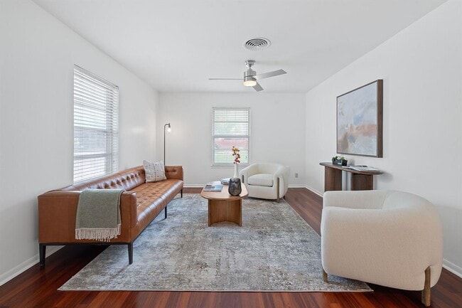
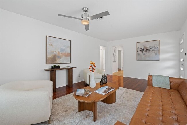
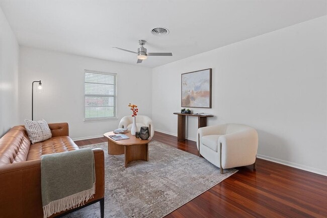
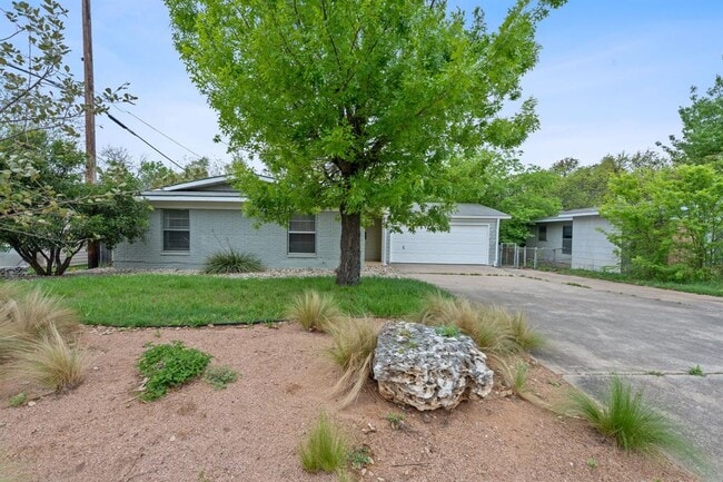
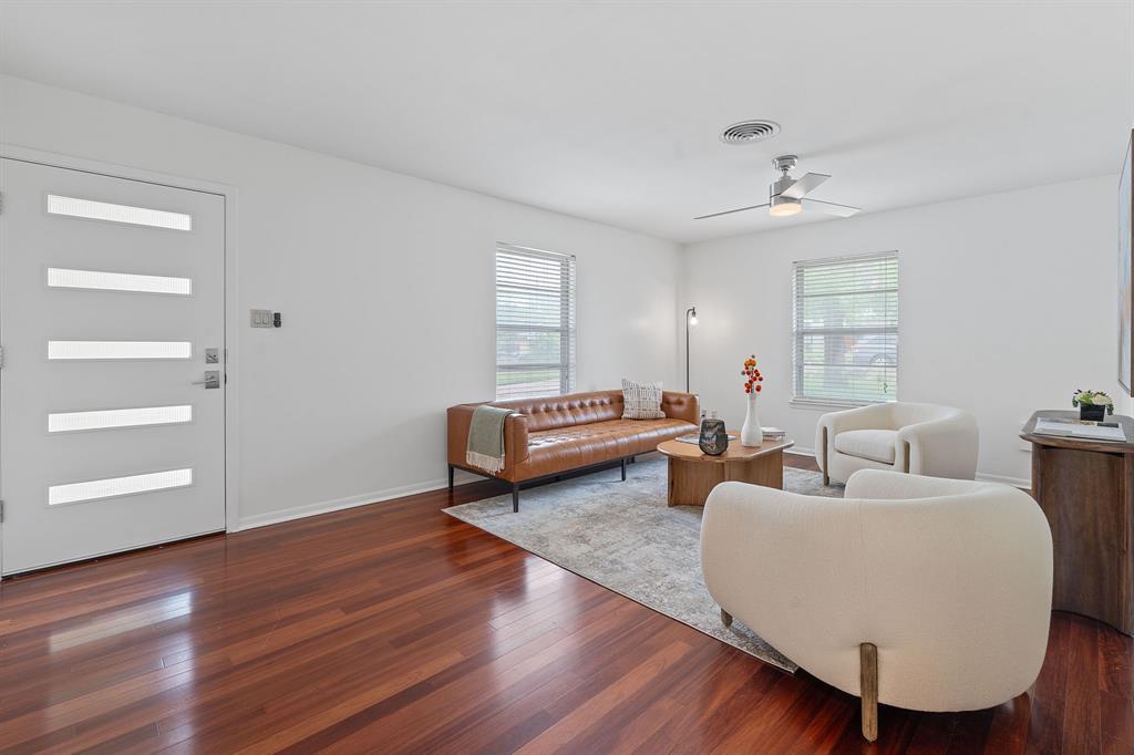
Welcome to 6810 Daugherty St. Come discover this charming 1960-built home located in the highly sought-after Allandale neighborhood. This property features 3 bedrooms and 2 full bathrooms, all situated on a generous 0.21-acre lot. An unbeatable north central location, just steps from the vibrant Burnet Road corridor, this home offers true walkability to a host of local destinations, including Barley Swine, Yard Bar, Taco Deli, Tumble 22, Dog Day Coffee, Lala’s Little Nugget, and more. Packed with original character and charm, the home boasts hardwood floors, all new interior paint, updated lighting, a 2 car garage, and a cozy backyard deck and porch ideal for entertaining. The home feeds into Gullett Elementary, Lamar Middle, and McCallum High.
6810 Daugherty St is a house located in Travis County and the 78757 ZIP Code. This area is served by the Austin Independent attendance zone.
* Price shown is base rent and may not include non-optional fees and utilities.
Price, availability, fees, and any applicable rent special are subject to change without notice.
* Square footage definitions vary. Displayed square footage is approximate.
Home Details
Home Type
Single Family Detached Home
Year Built
Built in 1960
Bedrooms and Bathrooms
3 Main Level Bedrooms
2 Full Bathrooms
Flooring
Wood
Tile
Home Design
Shingle Roof
Brick Exterior Construction
Composition Roof
HardiePlank Type
Slab Foundation
Home Security
Smart Thermostat
Fire and Smoke Detector
Interior Spaces
Recessed Lighting
Storage
1-Story Property
Ceiling Fan
Window Screens
1,288 Sq Ft Home
Aluminum Window Frames
Blinds
Kitchen
Granite Countertops
Electric Oven
Gas Range
Free-Standing Range
Microwave
Dishwasher
Disposal
Laundry
Washer and Dryer
Listing and Financial Details
Security Deposit $3,500
Negotiable Lease Term
$75 Application Fee
Assessor Parcel Number 02340302040000
Tax Block 7
Tenant pays for all utilities
Location
City Lot
Lot Details
9,148 Sq Ft Lot
Interior Lot
Landscaped
East Facing Home
Native Plants
Level Lot
Back Yard Fenced and Front Yard
Chain Link Fence
Outdoor Features
Deck
Covered patio or porch
Rain Gutters
Exterior Lighting
Parking
2 Car Attached Garage
Single Garage Door
Front Facing Garage
Inside Entrance
Garage Door Opener
Driveway
Schools
Gullett Elementary School
Lamar Middle School
Mccallum High School
Utilities
Central Heating and Cooling System
ENERGY STAR Qualified Water Heater
High Speed Internet
Cable TV Available
Natural Gas Connected
Community Details
Overview
No Home Owners Association
Green Acres Subdivision
Pet Policy
Breed Restrictions
Limit on the number of pets
Pet Size Limit
Pet Deposit $500
Fees and Policies
The fees below are based on community-supplied data and may exclude additional fees and utilities.
Pet policies are negotiable.
Contact
- Listed by Jason Lindenschmidt | LindenDwell Real Estate
- Phone Number
- Contact
-
Source
 Austin Board of REALTORS®
The information included in this listing is provided exclusively for consumers’ personal, non-commercial use and may not be used for any purpose other than to identify prospective properties consumers may be interested in purchasing. The information on each listing is furnished by the owner and deemed reliable to the best of his/her knowledge, but should be verified by the purchaser. ABoR, ACTRIS and Estately assume no responsibility for typographical errors, misprints or misinformation. This property listing is offered without respect to any protected classes in accordance with the law. Copyright © 2025.
Location
Get Directions
Amenities
- Dishwasher
- Disposal
- Microwave
- Hardwood Floors
- Tile Floors
Well-established and highly sought after, Allandale is considered one of Austin’s top neighborhoods. With its mature trees providing shady streets lined with ranch-style homes on manicured lawns, it’s easy to see why so many seek this park-like community. But its proximity to all things Austin – from the museums, theaters, and music venues downtown to the University of Texas at Austin – make it even more desirable.
Long before it became the trendy, sought-after neighborhood it is today, Allandale was part of an 1841 land grant to George W. Davis as a reward for his part in the Battle of San Jacinto. This early history is reflected in the Davis Family Cemetery, a historic cemetery, located off Vine Street. Other noteworthy locations include Beverly S. Sheffield Park, a large park with picnic tables, ball courts, and a playground, and the Northwest Recreation Center.
Learn more about living in Allandale
Education
| Colleges & Universities | Distance | ||
|---|---|---|---|
| Colleges & Universities | Distance | ||
| Drive: | 11 min | 5.3 mi | |
| Drive: | 11 min | 5.3 mi | |
| Drive: | 11 min | 6.8 mi | |
| Drive: | 14 min | 7.2 mi |
6810 Daugherty St is within 11 minutes or 5.3 miles from University of Texas at Austin. It is also near Austin C.C., Northridge Campus and Austin C.C., Rio Grande Campus.
Schools


Public Elementary School
Grades PK-5
565 Students
Attendance Zone
Public Middle School
Grades 6-8
1,182 Students
Attendance Zone
Public High School
Grades 9-12
1,824 Students
Attendance Zone
Private Elementary, Middle & High School
Grades K-12
Nearby
Private Elementary & Middle School
Grades PK-8
298 Students
Nearby
School data provided by
 The GreatSchools Rating helps parents compare schools within a state based on a variety of school quality indicators and provides a helpful picture of how effectively each school serves all of its students. Ratings are on a scale of 1 (below average) to 10 (above average) and can include test scores, college readiness, academic progress, advanced courses, equity, discipline and attendance data. We also advise parents to visit schools, consider other information on school performance and programs, and consider family needs as part of the school selection process.
View GreatSchools Rating Methodology
Data provided by GreatSchools.org © 2025. All rights reserved.
View GreatSchools Rating Methodology
Data provided by GreatSchools.org © 2025. All rights reserved.
Transportation options available in Austin include Crestview Station, located 1.7 miles from 6810 Daugherty St. 6810 Daugherty St is near Austin-Bergstrom International, located 16.0 miles or 30 minutes away.
| Transit / Subway | Distance | ||
|---|---|---|---|
| Transit / Subway | Distance | ||
| Drive: | 5 min | 1.7 mi | |
| Drive: | 5 min | 2.1 mi | |
| Drive: | 8 min | 4.1 mi | |
| Drive: | 9 min | 4.2 mi | |
| Drive: | 12 min | 6.2 mi |
| Commuter Rail | Distance | ||
|---|---|---|---|
| Commuter Rail | Distance | ||
|
|
Drive: | 13 min | 7.3 mi |
|
|
Drive: | 42 min | 31.6 mi |
|
|
Drive: | 47 min | 37.5 mi |
| Airports | Distance | ||
|---|---|---|---|
| Airports | Distance | ||
|
Austin-Bergstrom International
|
Drive: | 30 min | 16.0 mi |
Time and distance from 6810 Daugherty St.
| Shopping Centers | Distance | ||
|---|---|---|---|
| Shopping Centers | Distance | ||
| Walk: | 5 min | 0.3 mi | |
| Walk: | 5 min | 0.3 mi | |
| Walk: | 8 min | 0.5 mi |
6810 Daugherty St has 3 shopping centers within 0.5 mile, which is about a 8-minute walk. The miles and minutes will be for the farthest away property.
| Parks and Recreation | Distance | ||
|---|---|---|---|
| Parks and Recreation | Distance | ||
|
Beverly S. Sheffield Northwest District Park
|
Walk: | 7 min | 0.4 mi |
|
Bright Leaf Preserve
|
Drive: | 7 min | 3.1 mi |
|
Elisabet Ney Museum
|
Drive: | 7 min | 3.4 mi |
|
Bull Creek Greenbelt
|
Drive: | 8 min | 3.9 mi |
|
Mayfield Park and Preserve
|
Drive: | 9 min | 4.6 mi |
6810 Daugherty St has 5 parks within 4.6 miles, including Beverly S. Sheffield Northwest District Park, Bright Leaf Preserve, and Elisabet Ney Museum.
| Hospitals | Distance | ||
|---|---|---|---|
| Hospitals | Distance | ||
| Drive: | 6 min | 2.6 mi | |
| Drive: | 6 min | 2.9 mi | |
| Drive: | 6 min | 2.9 mi |
6810 Daugherty St has 3 hospitals within 2.9 miles, the nearest is Northwest Hills Surgical Hospital which is 2.6 miles away and a 6 minute drive.
| Military Bases | Distance | ||
|---|---|---|---|
| Military Bases | Distance | ||
| Drive: | 89 min | 71.4 mi | |
| Drive: | 90 min | 72.5 mi |
6810 Daugherty St is 71.4 miles from Fort Cavazos, and is convenient to other military bases, including Randolph Air Force Base.
You May Also Like
Similar Rentals Nearby


What Are Walk Score®, Transit Score®, and Bike Score® Ratings?
Walk Score® measures the walkability of any address. Transit Score® measures access to public transit. Bike Score® measures the bikeability of any address.
What is a Sound Score Rating?
A Sound Score Rating aggregates noise caused by vehicle traffic, airplane traffic and local sources
6810 Daugherty St
Austin, TX 78757