

$1,695
/ Month
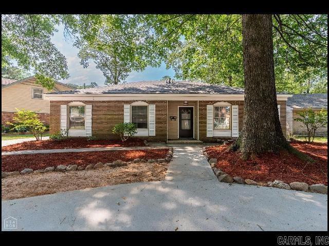
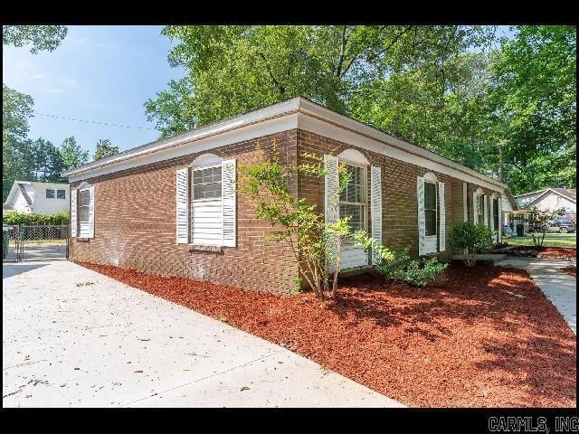
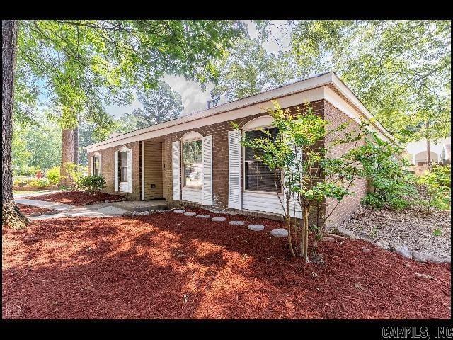
6809 Canna Rd
Little Rock, AR 72209
Today
Favorites
501-221-8888
-
Bedrooms
4
-
Bathrooms
3
-
Square Feet
2,430 sq ft
-
Available
Not Available
Highlight
- Central Heating and Cooling System
6809 Canna Rd

Favorites
About This Home
$1,695 deposit,
Not Available
*SOUTHWEST LITTLE ROCK* BEAUTIFUL HOME IN RUSTIC PINES SUBDIVISION!! This 4 Bedroom And 3 Bathroom Home Is RECENTLY UPDATED! ALL NEWER APPLIANCES INCLUDED!! Features Over 2400 Sqft Of Living Space, And Includes A Separate Living Room, Dining Room, And Bedroom/Bathroom With Own Covered Entrance! Fenced In Backyard! Pad For Parking! PET FRIENDLY!! AVAILABLE MID NOVEMBER 2025!!!
6809 Canna Rd is a house located in Pulaski County and the 72209 ZIP Code. This area is served by the Little Rock attendance zone.
* Price shown is base rent. Excludes user-selected optional fees and variable or usage-based fees and required charges due at or prior to move-in or at move-out. Price, availability, fees, and any applicable rent special are subject to change without notice.
* Square footage definitions vary. Displayed square footage is approximate.
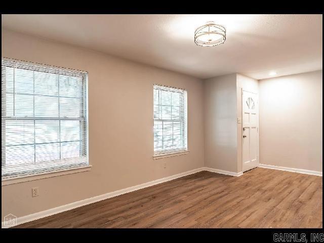
Home Details
Home Type
House
Year Built
Built in 1964
Bedrooms and Bathrooms
3 Full Bathrooms
4 Bedrooms
Interior Spaces
2,430 Sq Ft Home
Kitchen
Oven or Range
Dishwasher
Disposal
Laundry
Washer and Dryer Hookup
Listing and Financial Details
Security Deposit $1,695
Parking
2 Car Garage
Parking Pad
Utilities
Central Heating and Cooling System
Community Details
Pet Policy
Call for details about the types of pets allowed
Pet Deposit $250
Contact
- Listed by Roy Rainey Jr. | Rainey Realty, Inc.
- Phone Number
- Contact
-
Source
 Cooperative Arkansas Realtors® Multiple Listings Services, Inc.
Copyright ©2025 Cooperative Arkansas Realtors® Multiple Listings Services, Inc.
Location
Get Directions
Located less than ten miles southwest of Downtown Little Rock, Cloverdale Watson offers residents a quiet suburban atmosphere within minutes of big-city amenities. Multiple shopping centers provide Cloverdale Watson residents with a host of everyday conveniences, including groceries, repair services, clothing, and more. Recreational opportunities are abundant at Cloverdale Watson’s Ottenheimer Park, Thom Park, and Skate World as well.
Cloverdale Watson is within a short commuting distance from the University of Arkansas at Little Rock as well as Downtown Little Rock. Major attractions like the Arkansas State Fair, Little Rock Zoo, Park Plaza Mall, and the Outlets of Little Rock are also just a quick drive from Cloverdale Watson. Convenient access to I-30 and the Bill and Hillary Clinton National Airport makes getting around from Cloverdale Watson simple.
Learn more about living in Cloverdale Watson
Education
| Colleges & Universities | Distance | ||
|---|---|---|---|
| Colleges & Universities | Distance | ||
| Drive: | 10 min | 5.3 mi | |
| Drive: | 15 min | 8.0 mi | |
| Drive: | 14 min | 9.3 mi | |
| Drive: | 22 min | 13.7 mi |
6809 Canna Rd is within 10 minutes or 5.3 miles from UA Little Rock. It is also near Univ. of Ark. Medical Scis. and Philander Smith College.
Schools


Public Elementary School
Grades PK-5
867 Students
Nearby
Charter Elementary & Middle School
Grades K-8
638 Students
Nearby
Public Elementary School
Grades 3-5
413 Students
Attendance Zone
Charter Middle & High School
Grades 6-12
85 Students
Nearby
Public Middle School
Grades 6-8
665 Students
Attendance Zone
Private Elementary, Middle & High School
Grades PK-12
Nearby
Private Elementary & Middle School
Grades PK-8
228 Students
Nearby
School data provided by
 The GreatSchools Rating helps parents compare schools within a state based on a variety of school quality indicators and provides a helpful picture of how effectively each school serves all of its students. Ratings are on a scale of 1 (below average) to 10 (above average) and can include test scores, college readiness, academic progress, advanced courses, equity, discipline and attendance data. We also advise parents to visit schools, consider other information on school performance and programs, and consider family needs as part of the school selection process.
View GreatSchools Rating Methodology
Data provided by GreatSchools.org © 2025. All rights reserved.
View GreatSchools Rating Methodology
Data provided by GreatSchools.org © 2025. All rights reserved.
Transportation options available in Little Rock include 2Nd St & Rock St, located 9.4 miles from 6809 Canna Rd. 6809 Canna Rd is near Bill and Hillary Clinton Ntl/Adams Field, located 10.3 miles or 14 minutes away.
| Transit / Subway | Distance | ||
|---|---|---|---|
| Transit / Subway | Distance | ||
| Drive: | 14 min | 9.4 mi | |
| Drive: | 14 min | 9.5 mi | |
| Drive: | 14 min | 9.5 mi | |
| Drive: | 14 min | 9.6 mi | |
| Drive: | 14 min | 9.8 mi |
| Commuter Rail | Distance | ||
|---|---|---|---|
| Commuter Rail | Distance | ||
|
|
Drive: | 15 min | 10.4 mi |
|
|
Drive: | 44 min | 37.6 mi |
| Airports | Distance | ||
|---|---|---|---|
| Airports | Distance | ||
|
Bill and Hillary Clinton Ntl/Adams Field
|
Drive: | 14 min | 10.3 mi |
Time and distance from 6809 Canna Rd.
| Shopping Centers | Distance | ||
|---|---|---|---|
| Shopping Centers | Distance | ||
| Walk: | 13 min | 0.7 mi | |
| Walk: | 14 min | 0.7 mi | |
| Walk: | 14 min | 0.8 mi |
6809 Canna Rd has 3 shopping centers within 0.8 mile, which is about a 14-minute walk. The miles and minutes will be for the farthest away property.
| Parks and Recreation | Distance | ||
|---|---|---|---|
| Parks and Recreation | Distance | ||
|
Little Rock Zoo
|
Drive: | 13 min | 7.0 mi |
|
Central High School National Historic Site
|
Drive: | 15 min | 7.4 mi |
|
Little Rock Audubon Center
|
Drive: | 11 min | 8.2 mi |
|
Central Arkansas Nature Center
|
Drive: | 14 min | 9.3 mi |
|
Museum of Discovery
|
Drive: | 14 min | 9.3 mi |
6809 Canna Rd has 5 parks within 9.3 miles, including Little Rock Zoo, Central High School National Historic Site, and Little Rock Audubon Center.
| Hospitals | Distance | ||
|---|---|---|---|
| Hospitals | Distance | ||
| Drive: | 14 min | 7.6 mi | |
| Drive: | 14 min | 7.8 mi | |
| Drive: | 15 min | 10.2 mi |
6809 Canna Rd has 3 hospitals within 10.2 miles, the nearest is Arkansas State Hospital which is 7.6 miles away and a 14 minute drive.
| Military Bases | Distance | ||
|---|---|---|---|
| Military Bases | Distance | ||
| Drive: | 42 min | 23.4 mi | |
| Drive: | 39 min | 26.6 mi | |
| Drive: | 47 min | 34.1 mi |
6809 Canna Rd has 3 military bases within 34.1 miles, the nearest is Camp Joseph T. Robinson Hill which is 23.4 miles away and a 42 minute drive.
You May Also Like
Similar Rentals Nearby


What Are Walk Score®, Transit Score®, and Bike Score® Ratings?
Walk Score® measures the walkability of any address. Transit Score® measures access to public transit. Bike Score® measures the bikeability of any address.
What is a Sound Score Rating?
A Sound Score Rating aggregates noise caused by vehicle traffic, airplane traffic and local sources

6809 Canna Rd
Little Rock, AR 72209