$3,900 / Month
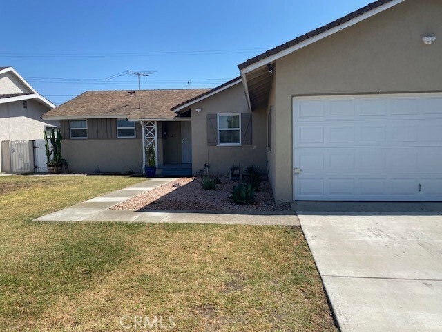
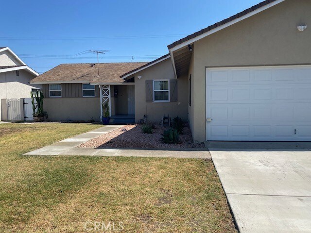
6748 San Alto Way
Buena Park, CA 90620
Today
Favorites
949-753-7888
-
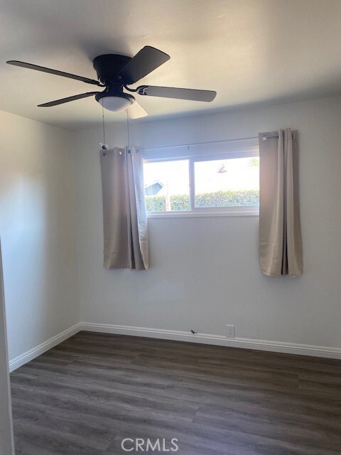
Bedrooms
4
-
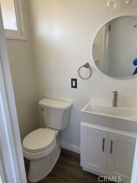
Bathrooms
2
-
Square Feet
1,210 sq ft
-
Available
Available May 11
Highlights
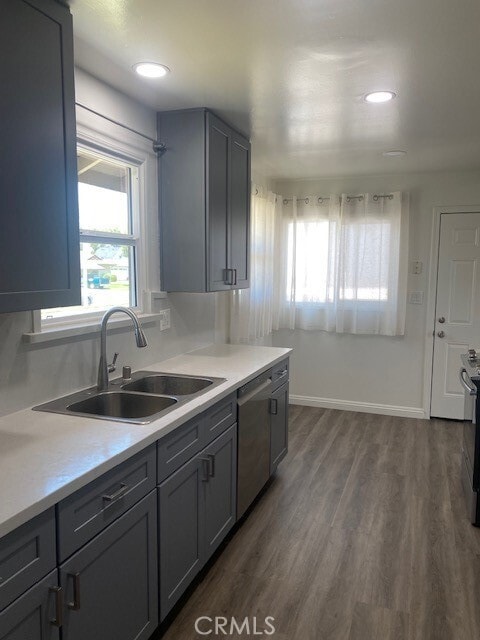
- Quartz Countertops
- Neighborhood Views
- 2 Car Attached Garage
- Laundry Room
- Central Heating
- Vinyl Flooring
6748 San Alto Way

Favorites
About This Home
12 Month Lease,
$2,500 deposit,
Available May 11
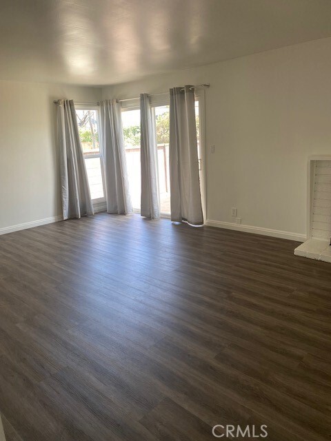
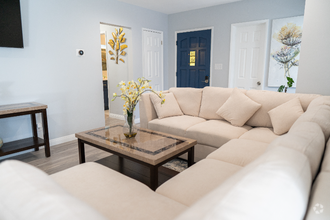
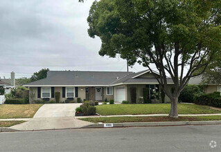
Welcome to 6748 San Alto Way, a charming and recently updated single-family home located in the heart of Buena Park. This well-maintained residence offers 4 bedrooms and 2 bathrooms. The home features an open layout, perfect for both relaxing and entertaining. The updated kitchen offers generous counter space and cabinetry, while the living and dining areas are filled with natural light. All bedrooms are moderately sized, and the bathrooms are clean and updated for modern living in a quiet neighborhood. Tenant must provide their own refrigerator, washer, dryer, and renter's insurance. Application Requirements: All prospective tenants must meet the qualifying criteria before applying via RentSpree. Credit and background checks will be conducted as part of the application process. Don’t miss out on this wonderful opportunity to live in a desirable Buena Park neighborhood! Contact us today for more information or to schedule a viewing.
6748 San Alto Way is a house located in Orange County and the 90620 ZIP Code. This area is served by the Anaheim Union High attendance zone.
* Price shown is base rent and may not include non-optional fees and utilities.
Price, availability, fees, and any applicable rent special are subject to change without notice.
* Square footage definitions vary. Displayed square footage is approximate.
Home Details
Home Type
Single Family Detached Home
Year Built
Built in 1957
Accessible Home Design
Entry on the 1st floor
Bedrooms and Bathrooms
4 Main Level Bedrooms
2 Full Bathrooms
Interior Spaces
Family Room with Fireplace
Vinyl Flooring
1,210 Sq Ft Home
1-Story Property
Kitchen
Quartz Countertops
Dishwasher
Laundry
Laundry Room
Washer and Gas Dryer Hookup
Listing and Financial Details
Security Deposit $2,500
12-Month Minimum Lease Term
Available 5/12/25
Tax Lot 61
Tax Tract Number 2422
Assessor Parcel Number 06948203
Location
Suburban Location
Lot Details
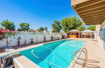
6,000 Sq Ft Lot
No Common Walls
Back and Front Yard
Parking
2 Car Attached Garage
Schools
Kennedy High School
Utilities
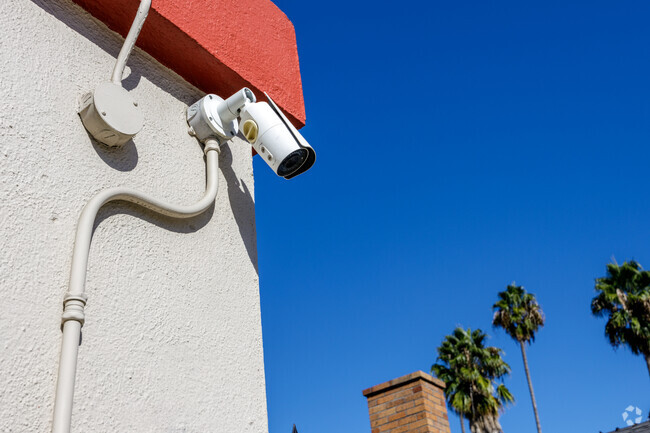
Central Heating
220 Volts in Garage
Views
Neighborhood Views
Community Details
Overview
No Home Owners Association
Pet Policy
Call for details about the types of pets allowed
Fees and Policies
The fees below are based on community-supplied data and may exclude additional fees and utilities.
- Parking
-
Other--
Details
Lease Options
-
12 Months
Contact
- Listed by Gina Oddo | Home Smart Evergreen Realty
- Phone Number
- Contact
-
Source
 California Regional Multiple Listing Service
Copyright 2025 © California Regional MLS. All rights reserved.
Location
Get Directions
Amenities
- Washer/Dryer Hookup
- Heating
- Fireplace
- Dishwasher
- Vinyl Flooring
Regarded as both an entertainment wonderland and the birthplace of the boysenberry, Buena Park is a SoCal suburb with a fascinating story. Located just west of Anaheim, Buena Park has a rich history as a rural town that evolved into a theme park destination. Knott’s Berry Farm, Buena Park’s most renowned landmark, began as a small family-owned berry farm. Today, Knott’s Berry Farm is known as California’s first theme park, drawing visitors from all over the world to enjoy its world-class rides, interactive experiences, shows, and delectable eats.
Outside of its Entertainment Corridor (which also includes Medieval Times, Pirate’s Dinner Adventure, Teatro Martini, and Knott’s Soak City water park), Buena Park offers residents access to a host of suburban conveniences in a central locale. Shopping options abound at Buena Park Mall, in addition to nearby Amerige Heights Town Center and Los Cerritos Center. Potential for outdoor recreation is endless at Ralph B Clark Park.
Learn more about living in Buena Park
Education
| Colleges & Universities | Distance | ||
|---|---|---|---|
| Colleges & Universities | Distance | ||
| Drive: | 3 min | 1.1 mi | |
| Drive: | 13 min | 6.5 mi | |
| Drive: | 13 min | 7.4 mi | |
| Drive: | 14 min | 8.6 mi |
6748 San Alto Way is within 3 minutes or 1.1 miles from Cypress College. It is also near Biola University and Cerritos College.
Schools


Public Elementary School
Grades K-6
493 Students
Attendance Zone
Public Elementary School
Grades K-6
323 Students
Nearby
Public Middle School
Grades 7-8
681 Students
Attendance Zone
Public High School
Grades 9-12
1,704 Students
Attendance Zone
Private Elementary School
Grades PK-3
54 Students
Nearby
School data provided by
 The GreatSchools Rating helps parents compare schools within a state based on a variety of school quality indicators and provides a helpful picture of how effectively each school serves all of its students. Ratings are on a scale of 1 (below average) to 10 (above average) and can include test scores, college readiness, academic progress, advanced courses, equity, discipline and attendance data. We also advise parents to visit schools, consider other information on school performance and programs, and consider family needs as part of the school selection process.
View GreatSchools Rating Methodology
View GreatSchools Rating Methodology
Transportation options available in Buena Park include Norwalk, located 9.3 miles from 6748 San Alto Way. 6748 San Alto Way is near Long Beach (Daugherty Field), located 10.6 miles or 19 minutes away, and John Wayne/Orange County, located 19.3 miles or 26 minutes away.
| Transit / Subway | Distance | ||
|---|---|---|---|
| Transit / Subway | Distance | ||
|
|
Drive: | 14 min | 9.3 mi |
|
|
Drive: | 17 min | 11.7 mi |
| Commuter Rail | Distance | ||
|---|---|---|---|
| Commuter Rail | Distance | ||
|
|
Drive: | 9 min | 4.6 mi |
|
|
Drive: | 14 min | 7.9 mi |
|
|
Drive: | 13 min | 8.1 mi |
|
|
Drive: | 17 min | 9.7 mi |
| Drive: | 17 min | 9.9 mi |
| Airports | Distance | ||
|---|---|---|---|
| Airports | Distance | ||
|
Long Beach (Daugherty Field)
|
Drive: | 19 min | 10.6 mi |
|
John Wayne/Orange County
|
Drive: | 26 min | 19.3 mi |
Time and distance from 6748 San Alto Way.
| Shopping Centers | Distance | ||
|---|---|---|---|
| Shopping Centers | Distance | ||
| Walk: | 8 min | 0.5 mi | |
| Walk: | 9 min | 0.5 mi | |
| Walk: | 11 min | 0.6 mi |
6748 San Alto Way has 3 shopping centers within 0.6 mile, which is about a 11-minute walk. The miles and minutes will be for the farthest away property.
| Parks and Recreation | Distance | ||
|---|---|---|---|
| Parks and Recreation | Distance | ||
|
El Dorado Nature Center
|
Drive: | 13 min | 6.8 mi |
|
El Dorado East Regional Park
|
Drive: | 15 min | 7.8 mi |
|
Children's Museum at La Habra
|
Drive: | 16 min | 9.3 mi |
|
La Habra Historical Museum
|
Drive: | 16 min | 9.5 mi |
|
Earl Burns Miller Japanese Garden
|
Drive: | 17 min | 9.6 mi |
6748 San Alto Way has 5 parks within 9.6 miles, including El Dorado Nature Center, El Dorado East Regional Park, and Earl Burns Miller Japanese Garden.
| Hospitals | Distance | ||
|---|---|---|---|
| Hospitals | Distance | ||
| Drive: | 4 min | 2.0 mi | |
| Drive: | 4 min | 2.2 mi | |
| Drive: | 10 min | 5.4 mi |
6748 San Alto Way has 3 hospitals within 5.4 miles, the nearest is La Palma Intercommunity Hospital which is 2.0 miles away and a 4 minute drive.
| Military Bases | Distance | ||
|---|---|---|---|
| Military Bases | Distance | ||
| Drive: | 10 min | 4.7 mi |
6748 San Alto Way is 4.7 miles and a 10 minute drive from Los Alamitos Army Airfield.
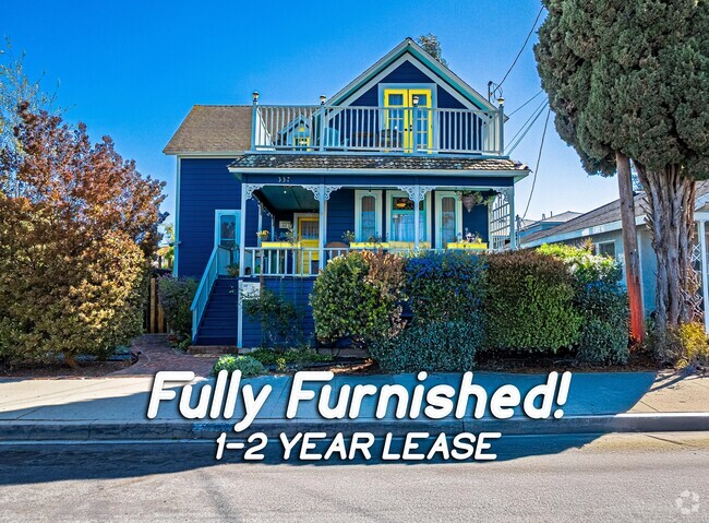
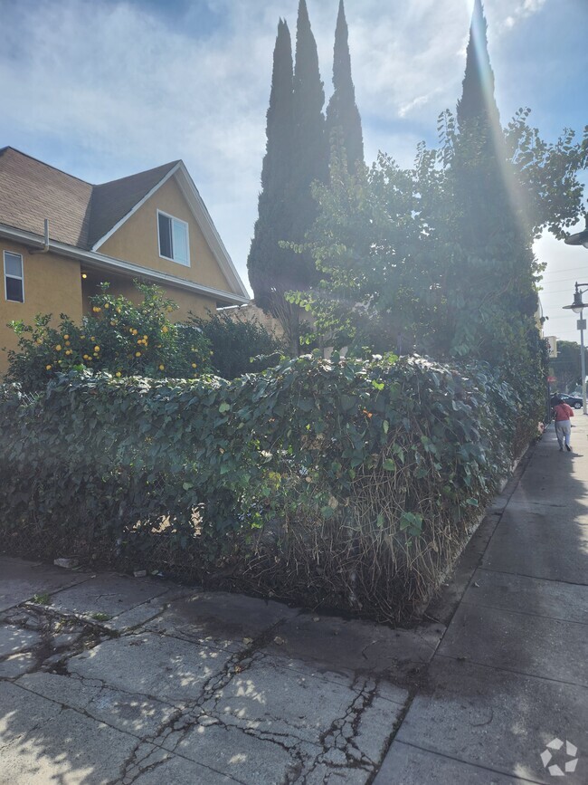
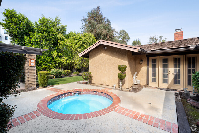
You May Also Like
Similar Rentals Nearby


What Are Walk Score®, Transit Score®, and Bike Score® Ratings?
Walk Score® measures the walkability of any address. Transit Score® measures access to public transit. Bike Score® measures the bikeability of any address.
What is a Sound Score Rating?
A Sound Score Rating aggregates noise caused by vehicle traffic, airplane traffic and local sources
6748 San Alto Way
Buena Park, CA 90620