
Presidential Towers
555 W Madison St,
Chicago, IL 60661
$1,641 - $6,588
Studio - 2 Beds
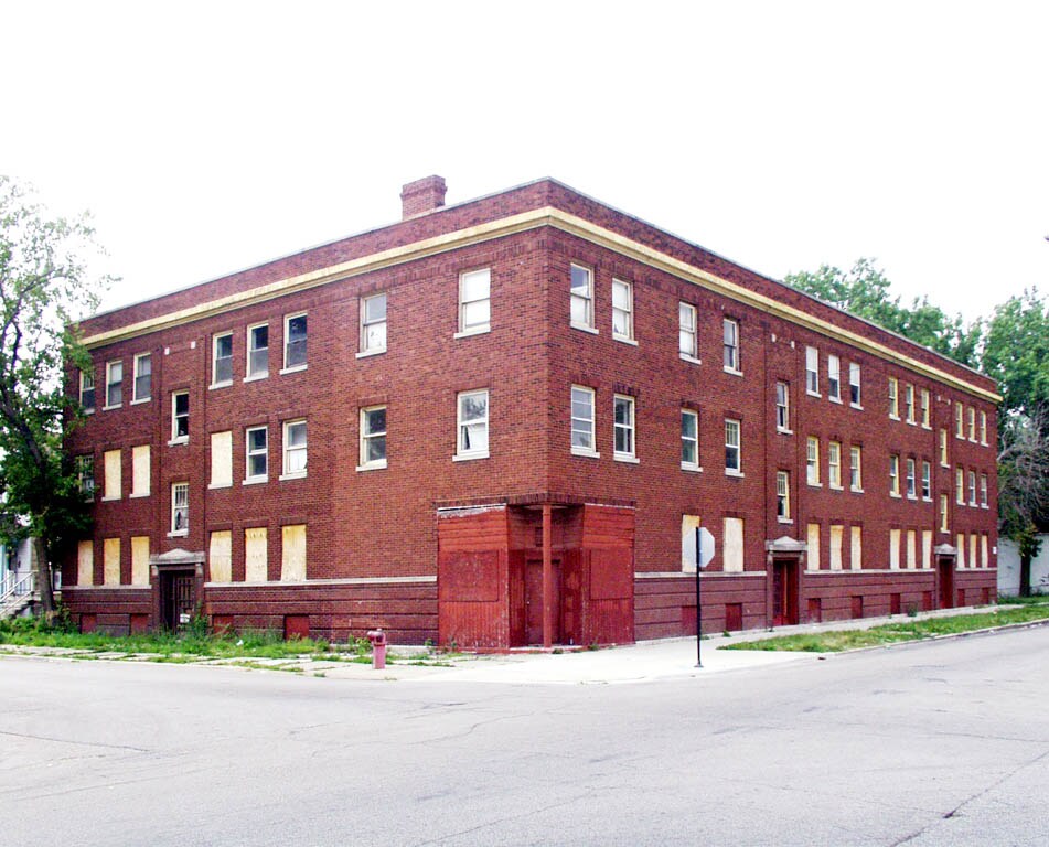
6748 S. May St. in Chicago is ready for you to visit. The 6748 S. May St. location in Chicago's 60621 area is an ideal place for residents. The leasing staff is ready to help you find your perfect fit. Make a visit to check out the current floorplan options. At 6748 S. May St. you'll feel right at home. Stop by the community today.
6748 S. May St. is an apartment community located in Cook County and the 60621 ZIP Code. This area is served by the Chicago Public Schools attendance zone.
Heating
Oven
Range
Kitchen
Englewood is a wonderful place to live with its abundance of schools, parks, and family-friendly areas. Englewood belongs to Chicago Public Schools, and the neighborhood offers a wide variety of schools from K-12. Kennedy-King Community College and a local culinary school also reside in Englewood. Community parks are spread all across town, but the largest are Ogden Park, which offers a public swimming pool, and Sherman Park, a beautiful green space that surrounds its own lagoon and is known as one of the nation’s first urban parks. It’s a great place to fish and watch the wildlife in the area.
Grocery stores, farmers markets, casual dining, and subway stations offer residents a multitude of amenities. Residents enjoy convenient access to major highways and a short commute to the Chicago area. Find your affordable apartment in Englewood so you can live less than 10 miles from Grant Park and all of downtown Chicago’s famous attractions.
Learn more about living in EnglewoodCompare neighborhood and city base rent averages by bedroom.
| Englewood | Chicago, IL | |
|---|---|---|
| Studio | $704 | $1,645 |
| 1 Bedroom | $863 | $2,048 |
| 2 Bedrooms | $1,094 | $2,587 |
| 3 Bedrooms | $1,394 | $3,092 |
| Colleges & Universities | Distance | ||
|---|---|---|---|
| Colleges & Universities | Distance | ||
| Drive: | 9 min | 4.7 mi | |
| Drive: | 10 min | 4.9 mi | |
| Drive: | 12 min | 6.1 mi | |
| Drive: | 14 min | 6.4 mi |


Transportation options available in Chicago include Halsted Station (Green Line), located 1.2 miles from 6748 S. May St.. 6748 S. May St. is near Chicago Midway International, located 6.9 miles or 14 minutes away, and Chicago O'Hare International, located 26.4 miles or 42 minutes away.
| Transit / Subway | Distance | ||
|---|---|---|---|
| Transit / Subway | Distance | ||
|
|
Drive: | 3 min | 1.2 mi |
|
|
Drive: | 3 min | 1.2 mi |
|
|
Drive: | 6 min | 2.8 mi |
|
|
Drive: | 7 min | 3.1 mi |
|
|
Drive: | 8 min | 4.0 mi |
| Commuter Rail | Distance | ||
|---|---|---|---|
| Commuter Rail | Distance | ||
|
|
Drive: | 6 min | 2.8 mi |
|
|
Drive: | 8 min | 3.5 mi |
|
|
Drive: | 8 min | 3.7 mi |
|
|
Drive: | 8 min | 3.7 mi |
|
|
Drive: | 11 min | 5.2 mi |
| Airports | Distance | ||
|---|---|---|---|
| Airports | Distance | ||
|
Chicago Midway International
|
Drive: | 14 min | 6.9 mi |
|
Chicago O'Hare International
|
Drive: | 42 min | 26.4 mi |
Scores provided by
Traffic
-Airport
-Businesses
-Scores provided by
HowLoud What is a Sound Score Rating? A Sound Score Rating aggregates noise caused by vehicle traffic, airplane traffic and local sources. How It WorksTime and distance from 6748 S. May St..
| Shopping Centers | Distance | ||
|---|---|---|---|
| Shopping Centers | Distance | ||
| Walk: | 9 min | 0.5 mi | |
| Walk: | 16 min | 0.8 mi | |
| Drive: | 3 min | 1.3 mi |
| Parks and Recreation | Distance | ||
|---|---|---|---|
| Parks and Recreation | Distance | ||
|
Ogden Park
|
Walk: | 9 min | 0.5 mi |
|
Hamilton Park
|
Drive: | 4 min | 1.6 mi |
|
Foster Park
|
Drive: | 6 min | 2.4 mi |
|
Gage Park
|
Drive: | 6 min | 3.2 mi |
|
Dan Ryan Woods
|
Drive: | 8 min | 3.7 mi |
| Hospitals | Distance | ||
|---|---|---|---|
| Hospitals | Distance | ||
| Drive: | 5 min | 1.9 mi | |
| Drive: | 6 min | 2.9 mi | |
| Drive: | 9 min | 4.5 mi |
| Military Bases | Distance | ||
|---|---|---|---|
| Military Bases | Distance | ||
| Drive: | 54 min | 32.2 mi | |
| Drive: | 50 min | 34.1 mi | |
| Drive: | 65 min | 37.2 mi |
What Are Walk Score®, Transit Score®, and Bike Score® Ratings?
Walk Score® measures the walkability of any address. Transit Score® measures access to public transit. Bike Score® measures the bikeability of any address.
What is a Sound Score Rating?
A Sound Score Rating aggregates noise caused by vehicle traffic, airplane traffic and local sources.

6748 S May St
Chicago, IL 60621


