
Presidential Towers
555 W Madison St,
Chicago, IL 60661
$1,657 - $6,648
Studio - 2 Beds
Bedrooms
1 bd
Bathrooms
1 ba
Square Feet
480 - 560 sq ft

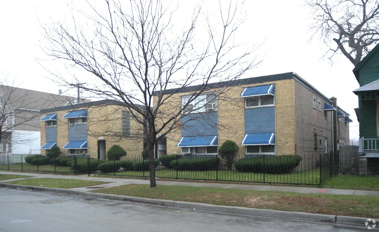
This 16 unit building in Greater Grand Crossing, Chicago features great amenities. Walking distance to Dunkin Donuts, Meyering Park, Save- A- Lot and can be easily accessed via CTA Red & Green Rail Lines. Call today for a showing!
This 16 unit building in Greater Grand Crossing, Chicago features great amenities. Walking distance to Dunkin Donuts, Meyering Park, Save- A- Lot and can be easily accessed via CTA Red & Green Rail Lines. Call today for a showing!
6618 S Wabash is an apartment community located in Cook County and the 60637 ZIP Code. This area is served by the Chicago Public Schools attendance zone.
Unique Features
Hardwood Floors
Heating
Range
Eat-in Kitchen
Being an urban neighborhood on the South Side of Chicago, Park Manor contains a wide selection of condos and townhouses for rent. Part of the Greater Grand Crossing community - about eight miles south of the Loop – Park Manor has a diverse history that dates back to the mid-1850s.
This pedestrian-friendly community allows residents to easily run errands; though, it’s also close to public transit and I-90. Locals gather just south of the neighborhood to visit the city library for computer and Wi-Fi access.
When residents want indoor meeting space or outdoor recreation, they go to the 3.1-acre Meyering Playground Park which has clubrooms, baseball diamonds, and basketball courts. Locals travel to the northeast edge of the neighborhood to feast on home-style cooking at Daley’s Restaurant.
Learn more about living in Park ManorCompare neighborhood and city base rent averages by bedroom.
| Park Manor | Chicago, IL | |
|---|---|---|
| Studio | $626 | $1,645 |
| 1 Bedroom | $896 | $2,048 |
| 2 Bedrooms | $811 | $2,587 |
| 3 Bedrooms | $1,038 | $3,092 |
| Colleges & Universities | Distance | ||
|---|---|---|---|
| Colleges & Universities | Distance | ||
| Drive: | 5 min | 2.6 mi | |
| Drive: | 9 min | 4.3 mi | |
| Drive: | 11 min | 5.4 mi | |
| Drive: | 12 min | 6.3 mi |


Transportation options available in Chicago include King Drive Station, located 1.0 miles from 6618 S Wabash. 6618 S Wabash is near Chicago Midway International, located 8.1 miles or 16 minutes away, and Chicago O'Hare International, located 25.1 miles or 39 minutes away.
| Transit / Subway | Distance | ||
|---|---|---|---|
| Transit / Subway | Distance | ||
|
|
Walk: | 20 min | 1.0 mi |
|
|
Drive: | 3 min | 1.5 mi |
|
|
Drive: | 4 min | 1.6 mi |
|
|
Drive: | 4 min | 2.1 mi |
|
|
Drive: | 5 min | 2.9 mi |
| Commuter Rail | Distance | ||
|---|---|---|---|
| Commuter Rail | Distance | ||
|
|
Drive: | 5 min | 2.1 mi |
|
|
Drive: | 5 min | 2.3 mi |
|
|
Drive: | 5 min | 2.4 mi |
| Drive: | 5 min | 2.5 mi | |
|
|
Drive: | 6 min | 3.1 mi |
| Airports | Distance | ||
|---|---|---|---|
| Airports | Distance | ||
|
Chicago Midway International
|
Drive: | 16 min | 8.1 mi |
|
Chicago O'Hare International
|
Drive: | 39 min | 25.1 mi |
Scores provided by
Traffic
-Airport
-Businesses
-Scores provided by
HowLoud What is a Sound Score Rating? A Sound Score Rating aggregates noise caused by vehicle traffic, airplane traffic and local sources. How It WorksTime and distance from 6618 S Wabash.
| Shopping Centers | Distance | ||
|---|---|---|---|
| Shopping Centers | Distance | ||
| Drive: | 3 min | 1.3 mi | |
| Drive: | 4 min | 1.6 mi |
| Parks and Recreation | Distance | ||
|---|---|---|---|
| Parks and Recreation | Distance | ||
|
Hamilton Park
|
Drive: | 4 min | 1.7 mi |
|
Washington Park
|
Drive: | 4 min | 1.9 mi |
|
Ogden Park
|
Drive: | 5 min | 2.0 mi |
|
Midway Plaisance Park
|
Drive: | 5 min | 2.6 mi |
|
Jackson Park
|
Drive: | 5 min | 2.6 mi |
| Hospitals | Distance | ||
|---|---|---|---|
| Hospitals | Distance | ||
| Walk: | 16 min | 0.8 mi | |
| Drive: | 5 min | 2.0 mi | |
| Drive: | 5 min | 2.6 mi |
| Military Bases | Distance | ||
|---|---|---|---|
| Military Bases | Distance | ||
| Drive: | 48 min | 32.8 mi | |
| Drive: | 54 min | 36.5 mi | |
| Drive: | 65 min | 41.6 mi |
What Are Walk Score®, Transit Score®, and Bike Score® Ratings?
Walk Score® measures the walkability of any address. Transit Score® measures access to public transit. Bike Score® measures the bikeability of any address.
What is a Sound Score Rating?
A Sound Score Rating aggregates noise caused by vehicle traffic, airplane traffic and local sources.

6618 S Wabash Ave
Chicago, IL 60637


