
$700
/ Month
6615 Fitts Rd
North Little Rock, AR 72118
Today
|
Edit
Favorites
501-230-6424
-
Bedrooms
2
-
Bathrooms
1.5
-
Square Feet
750 sq ft
-
Available
Not Available
Highlight
- Central Air
6615 Fitts Rd

Favorites
About This Home
Not Available
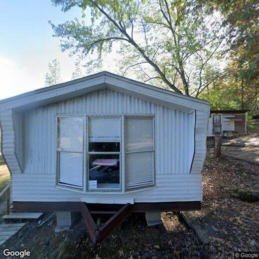
Mobile home for rent 700 per month with a 1 year lease and Deposit of 700. Mobile home is in good condition in a quite area right outside of the city limits but less than 10 min to I430, I630, I30, and I40. A nice 2 bed 1 1/2 bath with new floors and spacious living and open kitchen area. Washer/dryer hookups in unit. This one wont last long.
6615 Fitts Rd is a house located in Pulaski County and the 72118 ZIP Code. This area is served by the Capitol City Lighthouse Academy attendance zone.
* Price shown is base rent. Excludes user-selected optional fees and variable or usage-based fees and required charges due at or prior to move-in or at move-out. Price, availability, fees, and any applicable rent special are subject to change without notice.
* Square footage definitions vary. Displayed square footage is approximate.
Home Details
Home Type
Mobile Home
Year Built
Built in 1985
Bedrooms and Bathrooms
1.5 Bathrooms
2 Bedrooms
Interior Spaces
750 Sq Ft Home
Kitchen
Oven or Range
Cooktop
Laundry
Dryer
Washer
Parking
2 Carport Spaces
2 Car Garage
Utilities
Central Air
Community Details
Pet Policy
Call for details about the types of pets allowed
Contact
- Listed by Joshua Lafever | McKimmey Associates REALTORS NLR
- Phone Number
- Contact
-
Source
 Cooperative Arkansas Realtors® Multiple Listings Services, Inc.
Copyright ©2026 Cooperative Arkansas Realtors® Multiple Listings Services, Inc.
Location
Get Directions
North Little Rock sits on the north bank of the Arkansas River, directly across from the state capital, giving residents a city of their own with immediate access to a major metro area. The two cities share the iconic Big Dam Bridge, one of the longest pedestrian and bicycle bridges in the country built specifically for non-motorized travel, and the River Rail Streetcar, which connects both downtowns with a short, scenic ride. Originally called Argenta before incorporating as North Little Rock in 1917, the city carries that history proudly through its revitalized Argenta Historic District, where restored storefronts now house galleries, live theater, boutiques, and locally rooted restaurants. Burns Park, stretching over 1,700 acres, anchors the outdoor scene with golf courses, trails, tennis courts, and athletic fields. Neighborhoods like Park Hill and Lakewood offer distinct residential pockets within the city.
Learn more about living in North Little Rock
Education
| Colleges & Universities | Distance | ||
|---|---|---|---|
| Colleges & Universities | Distance | ||
| Drive: | 12 min | 5.5 mi | |
| Drive: | 14 min | 7.7 mi | |
| Drive: | 18 min | 9.5 mi | |
| Drive: | 22 min | 12.5 mi |
6615 Fitts Rd is within 12 minutes or 5.5 miles from Pulaski Technical College. It is also near Philander Smith College and Univ. of Ark. Medical Scis..
Schools


Charter Elementary School
Grades K-5
191 Students
Nearby
Charter Middle School
Grades 7-8
15 Students
Nearby
Public Middle School
Grades 6-8
83 Students
Nearby
Public High School
Grades 9-12
57 Students
Nearby
Private Elementary School
Grades K-5
23 Students
Nearby
School data provided by
 The GreatSchools Rating helps parents compare schools within a state based on a variety of school quality indicators and provides a helpful picture of how effectively each school serves all of its students. Ratings are on a scale of 1 (below average) to 10 (above average) and can include test scores, college readiness, academic progress, advanced courses, equity, discipline and attendance data. We also advise parents to visit schools, consider other information on school performance and programs, and consider family needs as part of the school selection process.
View GreatSchools Rating Methodology
Data provided by GreatSchools.org © 2026. All rights reserved.
View GreatSchools Rating Methodology
Data provided by GreatSchools.org © 2026. All rights reserved.
Transportation options available in North Little Rock include Main St & Bishop Lindsey Ave, located 5.7 miles from 6615 Fitts Rd. 6615 Fitts Rd is near Bill and Hillary Clinton Ntl/Adams Field, located 11.6 miles or 19 minutes away.
| Transit / Subway | Distance | ||
|---|---|---|---|
| Transit / Subway | Distance | ||
| Drive: | 10 min | 5.7 mi | |
| Drive: | 10 min | 5.8 mi | |
| Drive: | 10 min | 5.8 mi | |
| Drive: | 11 min | 6.0 mi | |
| Drive: | 11 min | 6.0 mi |
| Commuter Rail | Distance | ||
|---|---|---|---|
| Commuter Rail | Distance | ||
|
|
Drive: | 13 min | 7.1 mi |
| Airports | Distance | ||
|---|---|---|---|
| Airports | Distance | ||
|
Bill and Hillary Clinton Ntl/Adams Field
|
Drive: | 19 min | 11.6 mi |
Getting Around
 What do Walkability, Transit, Drivability, and Bikeability mean?
Walkability measures the walking distance to day-to-day needs.
Transit measures access to public transportation.
Drivability measures congestion, parking availability, and access to major roads.
Bikeability measures the suitability for cycling.
How It Works
What do Walkability, Transit, Drivability, and Bikeability mean?
Walkability measures the walking distance to day-to-day needs.
Transit measures access to public transportation.
Drivability measures congestion, parking availability, and access to major roads.
Bikeability measures the suitability for cycling.
How It Works
Not Walkable
Walkability
10
/ 100
Minimal Public Transit
Transit
0
/ 100
Exceptionally Drivable
Drivability
90
/ 100
Fairly Bikeable
Bikeability
40
/ 100
Scores provided by
-
Soundscore™
-
/ 100
Traffic
-Airport
-Businesses
-Scores provided by
HowLoud What is a Sound Score Rating? A Sound Score Rating aggregates noise caused by vehicle traffic, airplane traffic and local sources. How It WorksTime and distance from 6615 Fitts Rd.
| Shopping Centers | Distance | ||
|---|---|---|---|
| Shopping Centers | Distance | ||
| Drive: | 7 min | 3.6 mi | |
| Drive: | 8 min | 4.0 mi | |
| Drive: | 8 min | 4.1 mi |
6615 Fitts Rd has 3 shopping centers within 4.1 miles, which is about a 8-minute drive. The miles and minutes will be for the farthest away property.
| Parks and Recreation | Distance | ||
|---|---|---|---|
| Parks and Recreation | Distance | ||
|
Burns Park
|
Drive: | 9 min | 3.6 mi |
|
Museum of Discovery
|
Drive: | 12 min | 6.8 mi |
|
Central Arkansas Nature Center
|
Drive: | 12 min | 6.9 mi |
|
Central High School National Historic Site
|
Drive: | 17 min | 8.8 mi |
|
Little Rock Zoo
|
Drive: | 18 min | 10.7 mi |
6615 Fitts Rd has 5 parks within 10.7 miles, including Burns Park, Museum of Discovery, and Central Arkansas Nature Center.
| Hospitals | Distance | ||
|---|---|---|---|
| Hospitals | Distance | ||
| Drive: | 10 min | 4.4 mi | |
| Drive: | 9 min | 4.6 mi | |
| Drive: | 15 min | 7.9 mi |
6615 Fitts Rd has 3 hospitals within 7.9 miles, the nearest is The BridgeWay which is 4.4 miles away and a 10 minute drive.
| Military Bases | Distance | ||
|---|---|---|---|
| Military Bases | Distance | ||
| Drive: | 22 min | 8.5 mi | |
| Drive: | 33 min | 11.2 mi | |
| Drive: | 33 min | 17.2 mi |
6615 Fitts Rd has 3 military bases within 17.2 miles, the nearest is Camp Joseph T. Robinson Hill which is 8.5 miles away and a 22 minute drive.
You May Also Like
Similar Rentals Nearby


What Are Walk Score®, Transit Score®, and Bike Score® Ratings?
Walk Score® measures the walkability of any address. Transit Score® measures access to public transit. Bike Score® measures the bikeability of any address.
What is a Sound Score Rating?
A Sound Score Rating aggregates noise caused by vehicle traffic, airplane traffic and local sources.

6615 Fitts Rd
North Little Rock, AR 72118