
$2,650 / Month
66 Church St Unit 2
Wellesley, MA 02482
Today
Favorites
-
Bedrooms
2
-
Bathrooms
1
-
Square Feet
999 sq ft
-
Available
Available Aug 15
Highlights
- Pets Allowed
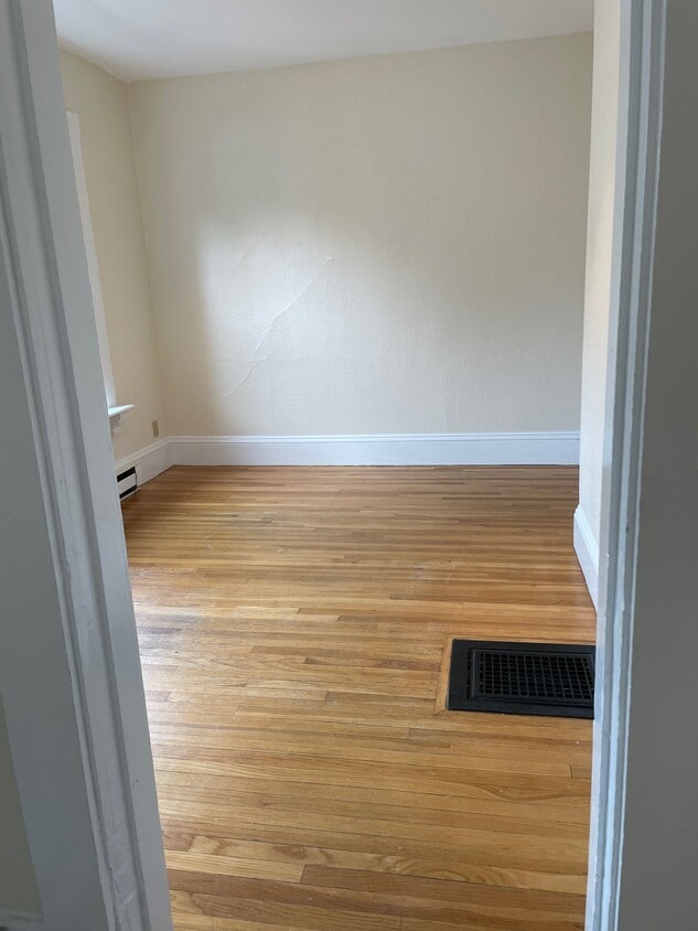
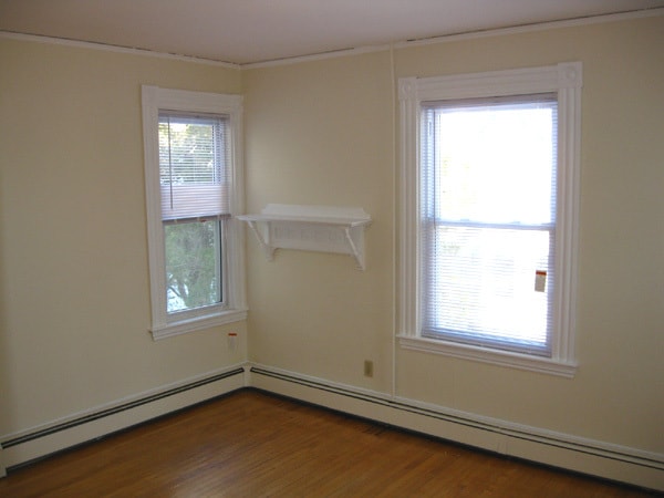
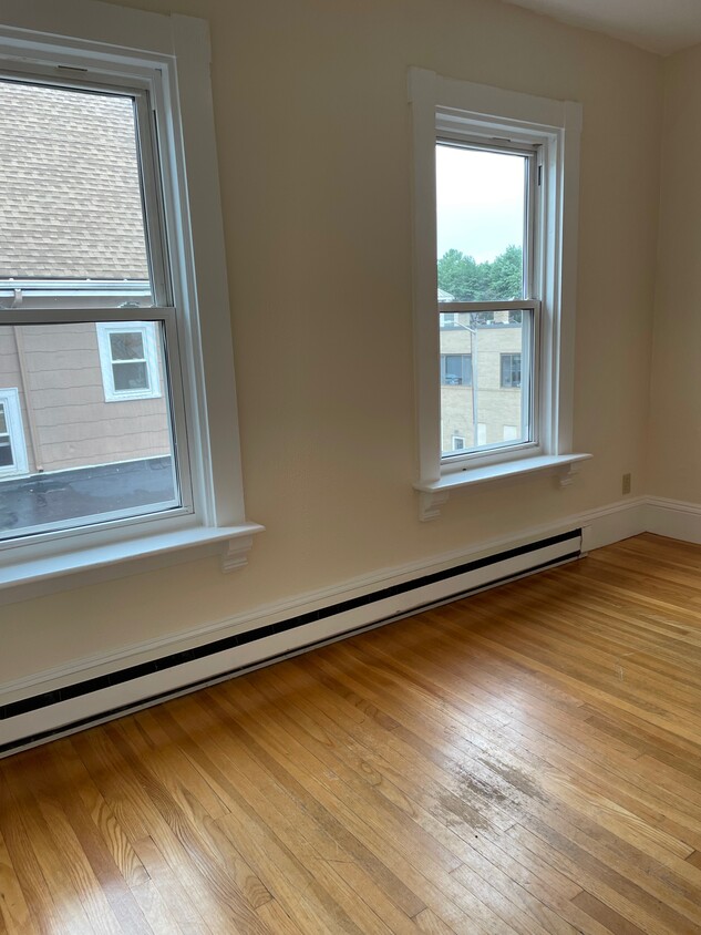
- Hardwood Floors
- Deck
66 Church St Unit 2

Favorites
About This Home
12 Month Lease,
$2,650 deposit,
Available Aug 15
Three family house with front porch off the center of Wellesley. Bright and sunny, hardwood floors. Front garden. Designated parking. Trash removal service.
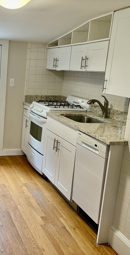
Bright & Sunny. Hardwood floors. Breakfast nook area in kitchen Studio in the heart of downtown Wellesley! Close to shops, restaurants, Starbucks College, Commuter Rail, Wellesley College and short walk to Linden St. shopping. Designated Parking space included. Friendly pet allowed. Laundry facility nearby Deposits for First Month and Full Security Deposit
66 Church St is an apartment community located in Norfolk County and the 02482 ZIP Code.
* Price shown is base rent and may not include non-optional fees and utilities.
Price, availability, fees, and any applicable rent special are subject to change without notice.
* Square footage definitions vary. Displayed square footage is approximate.
Apartment Features
Dishwasher
Hardwood Floors
Microwave
Refrigerator
- Dishwasher
- Kitchen
- Microwave
- Oven
- Range
- Refrigerator
- Freezer
- Hardwood Floors
- Laundry Facilities
- Porch
- Deck
Fees and Policies
The fees below are based on community-supplied data and may exclude additional fees and utilities.
- Dogs Allowed
-
Fees not specified
- Cats Allowed
-
Fees not specified
- Parking
-
Surface Lot--
Details
Utilities Included
-
Water
-
Trash Removal
-
Sewer
Property Information
-
3 units
Contact
- Contact
Location
Get Directions
Just west of Boston and East of Worcester sits Metro West, a region that houses a group of towns and cities with significant historical backgrounds. A total of 19 municipalities make up the core of this community, but other municipalities are considered to be a part of the Interstate 495/Metro West Corridor.
Learn more about living in Metro West
Education
| Colleges & Universities | Distance | ||
|---|---|---|---|
| Colleges & Universities | Distance | ||
| Walk: | 13 min | 0.7 mi | |
| Drive: | 5 min | 1.9 mi | |
| Drive: | 15 min | 6.5 mi | |
| Drive: | 16 min | 8.7 mi |
66 Church St Unit 2 is within 13 minutes or 0.7 mile from Wellesley College. It is also near Babson College and Brandeis University.
Transportation options available in Wellesley include Woodland Station, located 4.0 miles from 66 Church St Unit 2. 66 Church St Unit 2 is near General Edward Lawrence Logan International, located 18.0 miles or 30 minutes away, and Worcester Regional, located 31.9 miles or 54 minutes away.
| Transit / Subway | Distance | ||
|---|---|---|---|
| Transit / Subway | Distance | ||
|
|
Drive: | 8 min | 4.0 mi |
|
|
Drive: | 9 min | 4.1 mi |
|
|
Drive: | 9 min | 4.7 mi |
|
|
Drive: | 11 min | 5.3 mi |
|
|
Drive: | 11 min | 5.5 mi |
| Commuter Rail | Distance | ||
|---|---|---|---|
| Commuter Rail | Distance | ||
|
|
Walk: | 7 min | 0.4 mi |
|
|
Drive: | 3 min | 1.5 mi |
|
|
Drive: | 6 min | 2.8 mi |
|
|
Drive: | 5 min | 3.0 mi |
|
|
Drive: | 8 min | 3.6 mi |
| Airports | Distance | ||
|---|---|---|---|
| Airports | Distance | ||
|
General Edward Lawrence Logan International
|
Drive: | 30 min | 18.0 mi |
|
Worcester Regional
|
Drive: | 54 min | 31.9 mi |
Time and distance from 66 Church St Unit 2.
| Shopping Centers | Distance | ||
|---|---|---|---|
| Shopping Centers | Distance | ||
| Walk: | 1 min | 0.1 mi | |
| Walk: | 11 min | 0.6 mi | |
| Walk: | 15 min | 0.8 mi |
66 Church St Unit 2 has 3 shopping centers within 0.8 mile, which is about a 15-minute walk. The miles and minutes will be for the farthest away property.
| Parks and Recreation | Distance | ||
|---|---|---|---|
| Parks and Recreation | Distance | ||
|
Whitin Observatory
|
Walk: | 8 min | 0.5 mi |
|
Wellesley College Botanic Gardens
|
Walk: | 12 min | 0.7 mi |
|
Weezie's Garden for Children
|
Drive: | 7 min | 2.3 mi |
|
Elm Bank Reservation
|
Drive: | 7 min | 2.3 mi |
|
Horticultural Society at Elm Bank
|
Drive: | 8 min | 2.5 mi |
66 Church St Unit 2 has 5 parks within 2.5 miles, including Whitin Observatory, Wellesley College Botanic Gardens, and Horticultural Society at Elm Bank.
| Hospitals | Distance | ||
|---|---|---|---|
| Hospitals | Distance | ||
| Drive: | 7 min | 3.8 mi | |
| Drive: | 7 min | 3.8 mi | |
| Drive: | 14 min | 7.0 mi |
66 Church St Unit 2 has 3 hospitals within 7.0 miles, the nearest is Newton - Wellesley Hospital which is 3.8 miles away and a 7 minute drive.
| Military Bases | Distance | ||
|---|---|---|---|
| Military Bases | Distance | ||
| Drive: | 7 min | 3.6 mi | |
| Drive: | 25 min | 13.9 mi |
66 Church St Unit 2 is 3.6 miles from US Military Reservation, and is convenient to other military bases, including Hanscom Air Force Base.
Amenities
- Dishwasher
- Kitchen
- Microwave
- Oven
- Range
- Refrigerator
- Freezer
- Hardwood Floors
- Laundry Facilities
- Porch
- Deck
66 Church St Unit 2 Photos
What Are Walk Score®, Transit Score®, and Bike Score® Ratings?
Walk Score® measures the walkability of any address. Transit Score® measures access to public transit. Bike Score® measures the bikeability of any address.
What is a Sound Score Rating?
A Sound Score Rating aggregates noise caused by vehicle traffic, airplane traffic and local sources
66 Church St
Wellesley, MA 02482