

$3,400 / Month
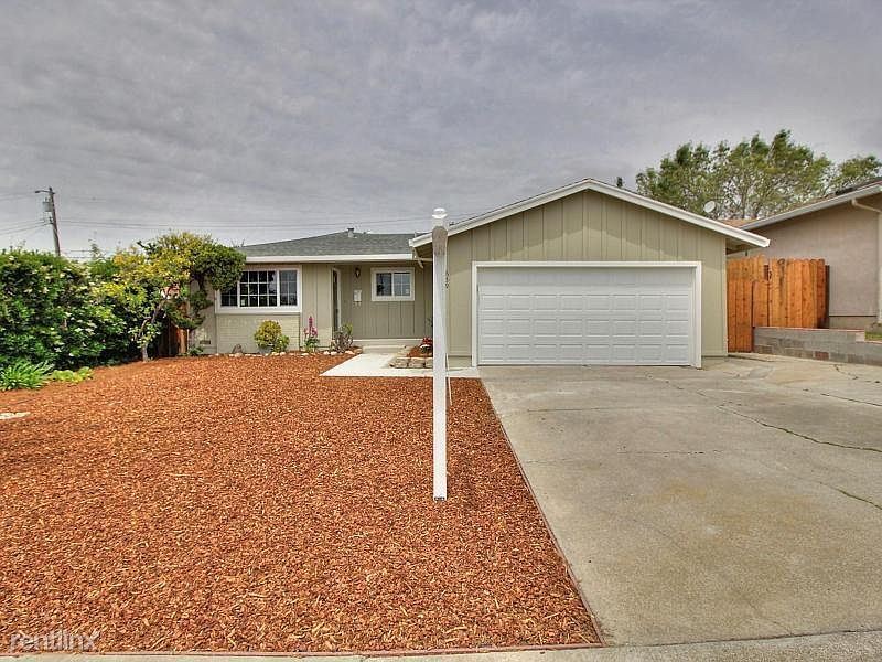
659 Starlite Way
Fremont, CA 94539
2 Weeks Ago
Favorites
659 Starlite Way

Favorites
Check Back Soon for Upcoming Availability
| Beds | Baths | Average SF |
|---|---|---|
| 3 Bedrooms 3 Bedrooms 3 Br | 2 Baths 2 Baths 2 Ba | 1,298 SF |
About This Property
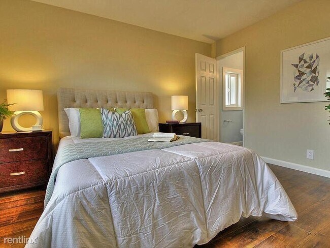
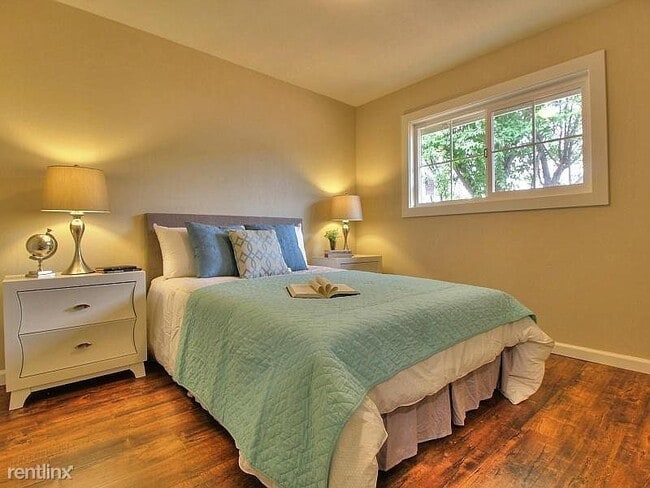
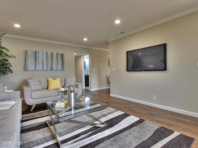
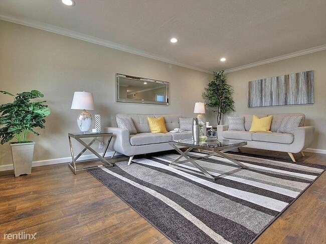
(650) 463-9203 - Click here to view the property on our page https://sandora.co/propertydetails/5f1f072d53f8b221e45239e6 Great Single Family Home in desirable WARM SPRINGS area. Fully upgraded house! Totally renovated 2 yrs ago.New kitchen! New bathroom! New paint inside and out! New hardwood (engineered) floors! New double pane windows! New doors! New copper plumbing! New light fixtures! Bright and open Floor plan, big kitchen, separate Living & Family room Great schools!! Easy access to 880 and 680 freeways. Easy commute to BART Minimum 1 Year Lease, NO SMOKING, NO PETS (RLNE6008982)
659 Starlite Way is a house located in Alameda County and the 94539 ZIP Code. This area is served by the Fremont Unified attendance zone.
Location
Get Directions
Warm Springs is a neighborhood in southern Fremont, adjacent to the Mission Peak Regional Preserve. Warm Springs is predominately residential with a few neighborhood parks with playgrounds. Totaling over 3,000 acres for recreational use, residents of Warm Springs love visiting Mission Peak for hiking, biking, RC flying, and hang gliding. There a few restaurants, cafes, tea shops, and a grocery store in Warm Springs, but residents typically travel a few minutes north or south for more shopping, dining, and entertainment options.
Conveniently, Warm Springs offers quick access to San Jose. Downtown San Jose is only 20 minutes away, so once you move into your new apartment, you’ll only be a short drive away from major attractions like the Tech Interactive, the San Jose Museum of Art, and Happy Hollow Park & Zoo. Get the best of both cities by finding your new home in Warm Springs today.
Learn more about living in Warm SpringsBelow are rent ranges for similar nearby apartments
Education
| Colleges & Universities | Distance | ||
|---|---|---|---|
| Colleges & Universities | Distance | ||
| Drive: | 9 min | 4.6 mi | |
| Drive: | 13 min | 7.4 mi | |
| Drive: | 13 min | 7.5 mi | |
| Drive: | 19 min | 12.2 mi |
659 Starlite Way is within 9 minutes or 4.6 miles from Ohlone College, Fremont Campus. It is also near Palmer College of Chiropractic West Campus and Ohlone College, Newark.
Schools


Public Elementary School
Grades K-5
343 Students
Nearby
Public Elementary School
Grades 1-2
588 Students
Attendance Zone
Public Elementary School
Grades 3-5
655 Students
Attendance Zone
Public Middle School
Grades 6-8
1,562 Students
Attendance Zone
Public High School
Grades 9-12
2,207 Students
Attendance Zone
Private Elementary School
Grades PK-5
84 Students
Nearby
Private Elementary School
Grades K
Nearby
Private Elementary, Middle & High School
Grades 1-12
Nearby
Private Elementary, Middle & High School
Grades 2-12
Nearby
School data provided by
 The GreatSchools Rating helps parents compare schools within a state based on a variety of school quality indicators and provides a helpful picture of how effectively each school serves all of its students. Ratings are on a scale of 1 (below average) to 10 (above average) and can include test scores, college readiness, academic progress, advanced courses, equity, discipline and attendance data. We also advise parents to visit schools, consider other information on school performance and programs, and consider family needs as part of the school selection process.
View GreatSchools Rating Methodology
Data provided by GreatSchools.org © 2025. All rights reserved.
View GreatSchools Rating Methodology
Data provided by GreatSchools.org © 2025. All rights reserved.
Transportation options available in Fremont include Warm Springs / South Fremont, located 2.9 miles from 659 Starlite Way. 659 Starlite Way is near Norman Y Mineta San Jose International, located 11.5 miles or 18 minutes away, and Metro Oakland International, located 27.0 miles or 36 minutes away.
| Transit / Subway | Distance | ||
|---|---|---|---|
| Transit / Subway | Distance | ||
|
|
Drive: | 6 min | 2.9 mi |
|
|
Drive: | 9 min | 5.0 mi |
| Drive: | 10 min | 5.3 mi | |
|
|
Drive: | 11 min | 6.1 mi |
|
|
Drive: | 11 min | 6.2 mi |
| Commuter Rail | Distance | ||
|---|---|---|---|
| Commuter Rail | Distance | ||
| Drive: | 14 min | 9.1 mi | |
| Drive: | 15 min | 10.0 mi | |
| Drive: | 16 min | 10.1 mi | |
| Drive: | 18 min | 12.0 mi | |
| Drive: | 18 min | 12.0 mi |
| Airports | Distance | ||
|---|---|---|---|
| Airports | Distance | ||
|
Norman Y Mineta San Jose International
|
Drive: | 18 min | 11.5 mi |
|
Metro Oakland International
|
Drive: | 36 min | 27.0 mi |
Time and distance from 659 Starlite Way.
| Shopping Centers | Distance | ||
|---|---|---|---|
| Shopping Centers | Distance | ||
| Walk: | 13 min | 0.7 mi | |
| Drive: | 4 min | 1.8 mi | |
| Drive: | 4 min | 1.8 mi |
659 Starlite Way has 3 shopping centers within 1.8 miles, which is about a 4-minute walk. The miles and minutes will be for the farthest away property.
| Parks and Recreation | Distance | ||
|---|---|---|---|
| Parks and Recreation | Distance | ||
|
Alviso Marina County Park
|
Drive: | 13 min | 7.7 mi |
|
Ed Levin County Park
|
Drive: | 17 min | 7.9 mi |
|
Ulistac Natural Area
|
Drive: | 16 min | 8.6 mi |
|
Mission Peak Regional Preserve
|
Drive: | 26 min | 9.3 mi |
|
Sunol Regional Wilderness
|
Drive: | 33 min | 17.1 mi |
659 Starlite Way has 5 parks within 17.1 miles, including Mission Peak Regional Preserve, Ed Levin County Park, and Alviso Marina County Park.
| Hospitals | Distance | ||
|---|---|---|---|
| Hospitals | Distance | ||
| Drive: | 14 min | 8.2 mi | |
| Drive: | 15 min | 9.3 mi | |
| Drive: | 14 min | 9.7 mi |
659 Starlite Way has 3 hospitals within 9.7 miles, the nearest is Kaiser Foundation Hospital - Fremont which is 8.2 miles away and a 14 minute drive.
| Military Bases | Distance | ||
|---|---|---|---|
| Military Bases | Distance | ||
| Drive: | 23 min | 14.3 mi |
659 Starlite Way is 14.3 miles and a 23 minute drive from Ames Research Center.
You May Also Like
Similar Rentals Nearby


What Are Walk Score®, Transit Score®, and Bike Score® Ratings?
Walk Score® measures the walkability of any address. Transit Score® measures access to public transit. Bike Score® measures the bikeability of any address.
What is a Sound Score Rating?
A Sound Score Rating aggregates noise caused by vehicle traffic, airplane traffic and local sources
659 Starlite Way
Fremont, CA 94539