

$3,700 / Month
659 South St
Waltham, MA 02453
Today
Favorites
617-386-3873
-
Bedrooms
3
-
Bathrooms
2
-
Square Feet
3,700 sq ft
-
Available
Available Aug 16
659 South St

Favorites
About This Home
$3,700 deposit,
Available Aug 16
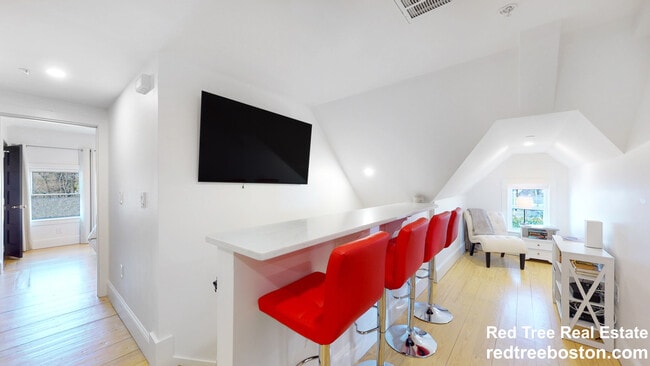
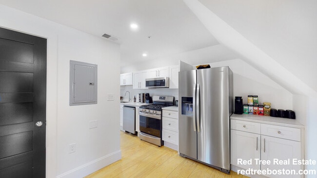
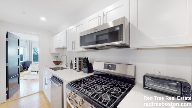
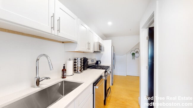
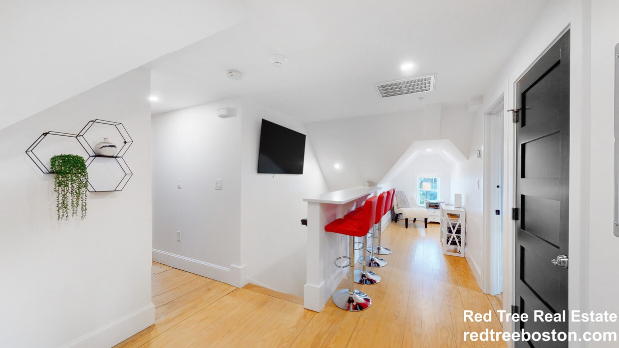
Stunning & spacious, three bedroom two bathroom fully renovated apartment in Waltham. This unit boasts a fully applianced (stainless steel) kitchen, in-unit laundry & more. Parking is available for rent. Moments from Brandeis & an easy commute to Bentley. Charles River & parks nearby.
659 South St is a townhome located in Middlesex County and the 02453 ZIP Code. This area is served by the Waltham attendance zone.
* Price shown is base rent and may not include non-optional fees and utilities.
Price, availability, fees, and any applicable rent special are subject to change without notice.
* Square footage definitions vary. Displayed square footage is approximate.
Townhome Features
- Washer/Dryer
- Washer/Dryer Hookup
- Dishwasher
Fees and Policies
The fees below are based on community-supplied data and may exclude additional fees and utilities.
- Dogs Allowed
-
Fees not specified
- Cats Allowed
-
Fees not specified
Contact
- Listed by Martin Bustamante
- Phone Number
- Contact
Location
Get Directions
Amenities
- Washer/Dryer
- Washer/Dryer Hookup
- Dishwasher
Roberts is a quaint community on the Stony Brook Basin near Interstate 95, just two miles from Downtown Waltham. Only a few streets make up this neighborhood, so residents enjoy peace and quiet in their picturesque, long-standing homes. Several moderately priced apartments and condos are available for rent in the area as well. Public bus stops sit in the neighborhood, as well as the Brandeis/Roberts train MBTA station. Roberts is adjacent to Brandeis University, so locals enjoy access to university attractions and amenities like the Rose Art Museum. Although Roberts is closer to Waltham, residents can still commute to Boston, located roughly 14 miles east.
Learn more about living in Roberts
Education
| Colleges & Universities | Distance | ||
|---|---|---|---|
| Colleges & Universities | Distance | ||
| Walk: | 13 min | 0.7 mi | |
| Drive: | 8 min | 3.8 mi | |
| Drive: | 13 min | 6.1 mi | |
| Drive: | 13 min | 7.2 mi |
659 South St is within 13 minutes or 0.7 mile from Brandeis University. It is also near Bentley University and Babson College.
Schools


Public Elementary School
Grades PK-5
383 Students
Attendance Zone
Public Middle School
Grades 6-8
595 Students
Attendance Zone
Public High School
Grades 9-12
1,751 Students
Attendance Zone
Private Elementary & Middle School
Grades PK-8
320 Students
Nearby
Private Elementary, Middle & High School
Grades 3-12
107 Students
Nearby
School data provided by
 The GreatSchools Rating helps parents compare schools within a state based on a variety of school quality indicators and provides a helpful picture of how effectively each school serves all of its students. Ratings are on a scale of 1 (below average) to 10 (above average) and can include test scores, college readiness, academic progress, advanced courses, equity, discipline and attendance data. We also advise parents to visit schools, consider other information on school performance and programs, and consider family needs as part of the school selection process.
View GreatSchools Rating Methodology
Data provided by GreatSchools.org © 2025. All rights reserved.
View GreatSchools Rating Methodology
Data provided by GreatSchools.org © 2025. All rights reserved.
Transportation options available in Waltham include Riverside Station, located 2.9 miles from 659 South St. 659 South St is near General Edward Lawrence Logan International, located 16.5 miles or 26 minutes away, and Worcester Regional, located 38.6 miles or 55 minutes away.
| Transit / Subway | Distance | ||
|---|---|---|---|
| Transit / Subway | Distance | ||
|
|
Drive: | 6 min | 2.9 mi |
|
|
Drive: | 6 min | 3.2 mi |
|
|
Drive: | 7 min | 3.9 mi |
|
|
Drive: | 10 min | 5.5 mi |
|
|
Drive: | 10 min | 5.7 mi |
| Commuter Rail | Distance | ||
|---|---|---|---|
| Commuter Rail | Distance | ||
|
|
Walk: | 6 min | 0.3 mi |
| Drive: | 5 min | 2.2 mi | |
|
|
Drive: | 6 min | 3.4 mi |
|
|
Drive: | 13 min | 8.7 mi |
|
|
Drive: | 14 min | 9.5 mi |
| Airports | Distance | ||
|---|---|---|---|
| Airports | Distance | ||
|
General Edward Lawrence Logan International
|
Drive: | 26 min | 16.5 mi |
|
Worcester Regional
|
Drive: | 55 min | 38.6 mi |
Time and distance from 659 South St.
| Shopping Centers | Distance | ||
|---|---|---|---|
| Shopping Centers | Distance | ||
| Walk: | 4 min | 0.2 mi | |
| Drive: | 4 min | 1.8 mi | |
| Drive: | 6 min | 2.7 mi |
659 South St has 3 shopping centers within 2.7 miles, which is about a 6-minute walk. The miles and minutes will be for the farthest away property.
| Parks and Recreation | Distance | ||
|---|---|---|---|
| Parks and Recreation | Distance | ||
|
Land's Sake Farm
|
Drive: | 7 min | 3.5 mi |
|
Beaver Brook Reservation
|
Drive: | 8 min | 4.5 mi |
|
Hemlock Gorge Reservation
|
Drive: | 10 min | 5.3 mi |
|
Hamlen Woods
|
Drive: | 13 min | 6.1 mi |
|
Hazel Brook Conservation Area
|
Drive: | 15 min | 7.2 mi |
659 South St has 5 parks within 7.2 miles, including Land's Sake Farm, Beaver Brook Reservation, and Hemlock Gorge Reservation.
| Hospitals | Distance | ||
|---|---|---|---|
| Hospitals | Distance | ||
| Drive: | 2 min | 1.3 mi | |
| Drive: | 5 min | 2.9 mi | |
| Drive: | 9 min | 4.9 mi |
659 South St has 3 hospitals within 4.9 miles, the nearest is Walden Behavioral Care which is 1.3 miles away and a 2 minute drive.
| Military Bases | Distance | ||
|---|---|---|---|
| Military Bases | Distance | ||
| Drive: | 18 min | 9.5 mi | |
| Drive: | 17 min | 9.6 mi |
659 South St is 9.5 miles from Hanscom Air Force Base, and is convenient to other military bases, including US Military Reservation.
You May Also Like
Similar Rentals Nearby


What Are Walk Score®, Transit Score®, and Bike Score® Ratings?
Walk Score® measures the walkability of any address. Transit Score® measures access to public transit. Bike Score® measures the bikeability of any address.
What is a Sound Score Rating?
A Sound Score Rating aggregates noise caused by vehicle traffic, airplane traffic and local sources
659 South St
Waltham, MA 02453