
$3,350 / Month
658 N Poplar Ct
Chandler, AZ 85226
2 Weeks Ago
Favorites
658 N Poplar Ct

Favorites
Check Back Soon for Upcoming Availability
| Beds | Baths | Average SF |
|---|---|---|
| 5 Bedrooms 5 Bedrooms 5 Br | 2 Baths 2 Baths 2 Ba | 2,464 SF |
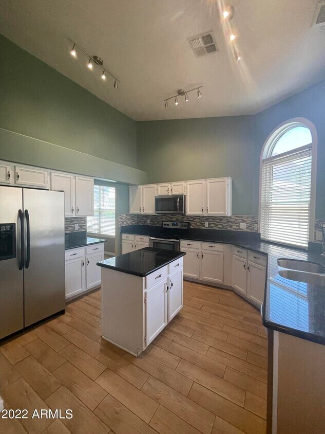
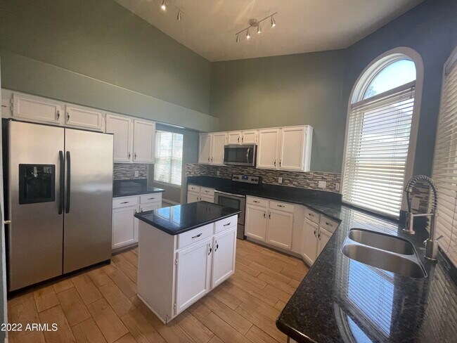
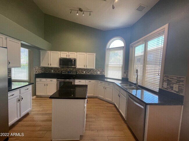
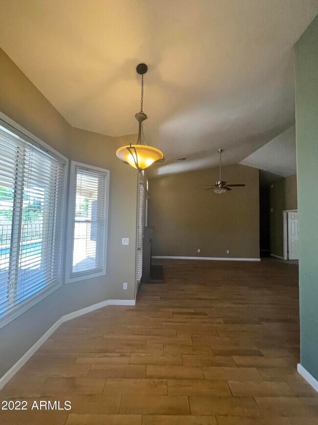
About This Property
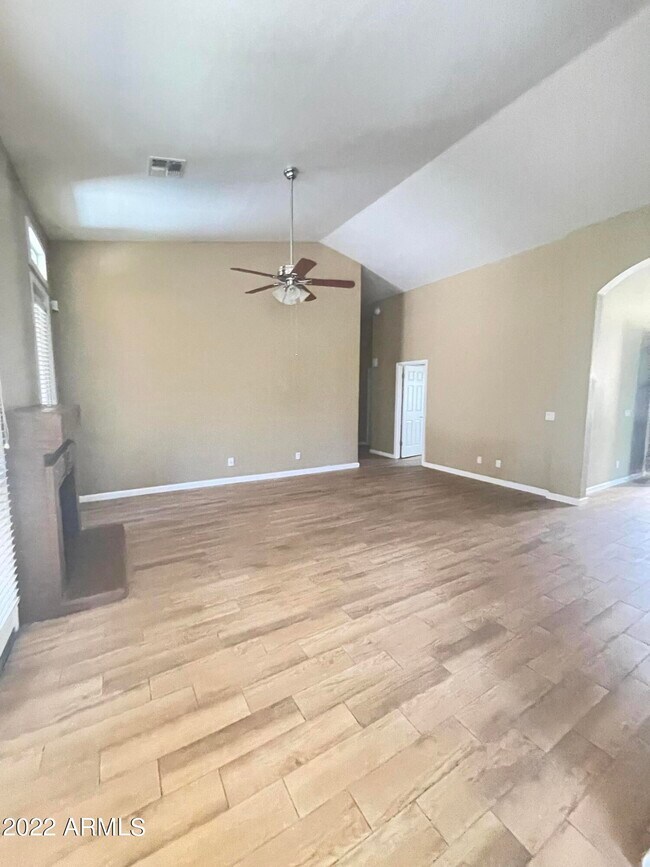
Open floor plan,5 bedrooms with two-bathroom,vaulted ceiling,upgraded wood flooring,light fixtures,and fireplace in the family room,granite countertops,stainless steel appliances,full backsplash,island,and walk-in-pantry. Two-tone paints,ceiling fans,fenced pool. Quiet cul-de-sac easy walking to Gila Spring fountains,green belts,and lakes. Close to everything,library,restaurants,Chandler fashion mall,medical clinics,banks,grocery,Costco,Walmart. Easy access to I-10,101,202.
658 N Poplar Ct is a house located in Maricopa County and the 85226 ZIP Code. This area is served by the Kyrene Elementary attendance zone.
Location
Get Directions
Situated about four miles west of Downtown Chandler, West Chandler is a scenic suburb brimming with recreation and retail. West Chandler residents enjoy access to an array of local parks, including Desert Breeze Park, Nozomi Park, and Hanger Park, as well as close proximity to the sprawling South Mountain Park.
Retail options in West Chandler provide a host of modern delights and everyday conveniences, with numerous shopping centers and plazas strewn throughout the area in addition to the upscale Chandler Fashion Center. West Chandler is also convenient to the popular Lone Butte Casino. Getting around from West Chandler is easy with access to the Santan Freeway, Maricopa Freeway, and the Price Freeway.
Learn more about living in West ChandlerBelow are rent ranges for similar nearby apartments
Education
| Colleges & Universities | Distance | ||
|---|---|---|---|
| Colleges & Universities | Distance | ||
| Drive: | 17 min | 8.5 mi | |
| Drive: | 17 min | 9.2 mi | |
| Drive: | 17 min | 10.2 mi | |
| Drive: | 20 min | 10.6 mi |
658 N Poplar Ct is within 17 minutes or 8.5 miles from Arizona State University. It is also near Mesa C.C., Southern and Dobson and South Mountain Comm. Coll..
Schools


Public Elementary & Middle School
Grades 5-8
615 Students
Attendance Zone
Public Elementary School
Grades PK-5
568 Students
Attendance Zone
Public High School
Grades 9-12
2,733 Students
Attendance Zone
Private Elementary & Middle School
Grades PK-8
332 Students
Nearby
Private Middle & High School
Grades 6-12
Nearby
School data provided by
 The GreatSchools Rating helps parents compare schools within a state based on a variety of school quality indicators and provides a helpful picture of how effectively each school serves all of its students. Ratings are on a scale of 1 (below average) to 10 (above average) and can include test scores, college readiness, academic progress, advanced courses, equity, discipline and attendance data. We also advise parents to visit schools, consider other information on school performance and programs, and consider family needs as part of the school selection process.
View GreatSchools Rating Methodology
Data provided by GreatSchools.org © 2025. All rights reserved.
View GreatSchools Rating Methodology
Data provided by GreatSchools.org © 2025. All rights reserved.
Transportation options available in Chandler include Eleventh St/Mill, located 7.9 miles from 658 N Poplar Ct. 658 N Poplar Ct is near Phoenix Sky Harbor International, located 12.9 miles or 21 minutes away, and Phoenix-Mesa Gateway, located 19.3 miles or 29 minutes away.
| Transit / Subway | Distance | ||
|---|---|---|---|
| Transit / Subway | Distance | ||
|
|
Drive: | 15 min | 7.9 mi |
|
|
Drive: | 16 min | 8.0 mi |
|
|
Drive: | 16 min | 8.0 mi |
|
|
Drive: | 16 min | 8.3 mi |
|
|
Drive: | 18 min | 9.3 mi |
| Commuter Rail | Distance | ||
|---|---|---|---|
| Commuter Rail | Distance | ||
|
|
Drive: | 30 min | 20.4 mi |
| Airports | Distance | ||
|---|---|---|---|
| Airports | Distance | ||
|
Phoenix Sky Harbor International
|
Drive: | 21 min | 12.9 mi |
|
Phoenix-Mesa Gateway
|
Drive: | 29 min | 19.3 mi |
Time and distance from 658 N Poplar Ct.
| Shopping Centers | Distance | ||
|---|---|---|---|
| Shopping Centers | Distance | ||
| Walk: | 12 min | 0.6 mi | |
| Walk: | 18 min | 0.9 mi | |
| Drive: | 2 min | 1.1 mi |
658 N Poplar Ct has 3 shopping centers within 1.1 miles, which is about a 2-minute walk. The miles and minutes will be for the farthest away property.
| Parks and Recreation | Distance | ||
|---|---|---|---|
| Parks and Recreation | Distance | ||
|
Pecos Park
|
Drive: | 8 min | 3.9 mi |
|
South Mountain Park
|
Drive: | 14 min | 6.6 mi |
|
ASU Center for Meteorite Studies
|
Drive: | 18 min | 8.5 mi |
|
Desert Arboretum Park
|
Drive: | 18 min | 9.0 mi |
|
Camelback Mountain Park
|
Drive: | 28 min | 14.6 mi |
658 N Poplar Ct has 5 parks within 14.6 miles, including Pecos Park, South Mountain Park, and ASU Center for Meteorite Studies.
| Hospitals | Distance | ||
|---|---|---|---|
| Hospitals | Distance | ||
| Drive: | 8 min | 4.3 mi | |
| Drive: | 8 min | 4.4 mi | |
| Drive: | 10 min | 5.4 mi |
658 N Poplar Ct has 3 hospitals within 5.4 miles, the nearest is Aurora Behavioral Healthcare - Tempe which is 4.3 miles away and a 8 minute drive.
| Military Bases | Distance | ||
|---|---|---|---|
| Military Bases | Distance | ||
| Drive: | 20 min | 13.7 mi | |
| Drive: | 50 min | 38.1 mi | |
| Drive: | 98 min | 79.2 mi |
658 N Poplar Ct has 3 military bases within 79.2 miles, the nearest is Phoenix Sky Harbor Airport Air Guard Station which is 13.7 miles away and a 20 minute drive.
You May Also Like
Similar Rentals Nearby
-
-
-
-
1 / 22

-

-
-

-

-

-


What Are Walk Score®, Transit Score®, and Bike Score® Ratings?
Walk Score® measures the walkability of any address. Transit Score® measures access to public transit. Bike Score® measures the bikeability of any address.
What is a Sound Score Rating?
A Sound Score Rating aggregates noise caused by vehicle traffic, airplane traffic and local sources

658 N Poplar Ct
Chandler, AZ 85226