

$1,765
/ Month
655 Santa Maria Rd Unit B
El Sobrante, CA 94803
2 Weeks Ago
|
Edit
Favorites
510-806-7813
-
Bedrooms
Studio
-
Bathrooms
1
-
Square Feet
476 sq ft
-
Available
Available Now
Highlights
- Pets Allowed
- Patio
- Smoke Free
655 Santa Maria Rd Unit B

Favorites
About This Home
12 Month Lease,
$1,765 deposit,
Available Now
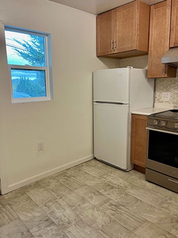
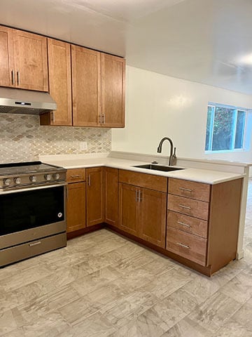
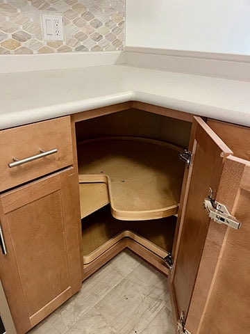
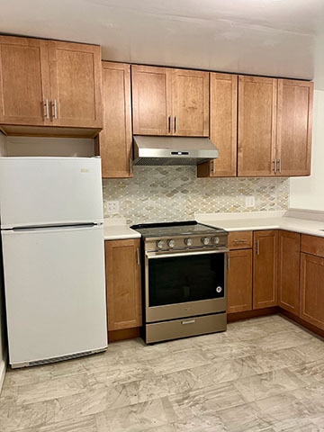
In-law Studio Available Now Enjoy a quiet, newly renovated spacious studio. Great natural light. Move-in ready. Full-sized kitchen with all new countertops/cabinets with whisper-close drawers. New stove/oven, range hood, and garbage disposal. Bathroom completely remodeled. Glass enclosed shower with marble walls and trim. Close to freeways, shopping, and movie theater. Included: Water, gas, electric, and garbage Private patio Off-street parking space
655 Santa Maria Rd is an apartment community located in Contra Costa County and the 94803 ZIP Code. This area is served by the West Contra Costa Unified attendance zone.
* Price shown is base rent. Excludes user-selected optional fees and variable or usage-based fees and required charges due at or prior to move-in or at move-out. Price, availability, fees, and any applicable rent special are subject to change without notice.
* Square footage definitions vary. Displayed square footage is approximate.
Apartment Features
Refrigerator
Disposal
Stainless Steel Appliances
Smoke Free
- Heating
- Smoke Free
- Disposal
- Stainless Steel Appliances
- Kitchen
- Oven
- Range
- Refrigerator
- Vinyl Flooring
- Mother-in-law Unit
- Patio
Fees and Policies
The fees below are based on community-supplied data and may exclude additional fees and utilities.
- Dogs Allowed
-
Fees not specified
- Cats Allowed
-
Fees not specified
Details
Utilities Included
-
Gas
-
Water
-
Electricity
-
Heat
-
Trash Removal
-
Sewer
Property Information
-
2 units
Contact
- Phone Number
- Contact
Location
Get Directions
El Sobrante, which translates to “surplus” in Spanish, is a census designated place in Contra Costa County. Situated about 20 miles northwest of San Francisco, El Sobrante offers residents a quiet place to call home among tree-laden hills as well as convenience to one of the most dynamic cities in the United States.
While El Sobrante is a predominantly residential area, it is accessible to numerous retailers in the Pinole Vista Shopping Center and Hilltop Mall in addition to a variety of thrift stores and restaurants scattered along San Pablo Dam Road. El Sobrante residents enjoy the many outdoor recreational opportunities in their backyard, with Pinole Valley Park, Kennedy Grove Regional Recreation Area, Alvarado Park, Wildcat Canyon Regional Park, and San Pablo Reservoir Recreation Area all nearby. Easy access to the I-80 makes getting around from El Sobrante simple.
Learn more about living in El Sobrante
Education
| Colleges & Universities | Distance | ||
|---|---|---|---|
| Colleges & Universities | Distance | ||
| Drive: | 5 min | 2.0 mi | |
| Drive: | 18 min | 11.3 mi | |
| Drive: | 22 min | 12.3 mi | |
| Drive: | 26 min | 15.9 mi |
655 Santa Maria Rd Unit B is within 5 minutes or 2.0 miles from Contra Costa College. It is also near Berkeley City College and UC Berkeley.
Schools


Public Elementary School
Grades K-5
270 Students
Nearby
Public Elementary School
Grades K-6
404 Students
Attendance Zone
Public Middle School
Grades 6-8
401 Students
Attendance Zone
Public High School
Grades 9-12
1,237 Students
Attendance Zone
Private Elementary, Middle & High School
Grades PK-12
Nearby
Private Elementary, Middle & High School
Grades K-12
Nearby
School data provided by
 The GreatSchools Rating helps parents compare schools within a state based on a variety of school quality indicators and provides a helpful picture of how effectively each school serves all of its students. Ratings are on a scale of 1 (below average) to 10 (above average) and can include test scores, college readiness, academic progress, advanced courses, equity, discipline and attendance data. We also advise parents to visit schools, consider other information on school performance and programs, and consider family needs as part of the school selection process.
View GreatSchools Rating Methodology
Data provided by GreatSchools.org © 2026. All rights reserved.
View GreatSchools Rating Methodology
Data provided by GreatSchools.org © 2026. All rights reserved.
Transportation options available in El Sobrante include El Cerrito Del Norte, located 5.3 miles from 655 Santa Maria Rd Unit B. 655 Santa Maria Rd Unit B is near Metro Oakland International, located 24.3 miles or 33 minutes away, and San Francisco International, located 31.9 miles or 45 minutes away.
| Transit / Subway | Distance | ||
|---|---|---|---|
| Transit / Subway | Distance | ||
|
|
Drive: | 9 min | 5.3 mi |
|
|
Drive: | 9 min | 5.3 mi |
|
|
Drive: | 9 min | 5.5 mi |
|
|
Drive: | 11 min | 7.1 mi |
|
|
Drive: | 16 min | 10.6 mi |
| Commuter Rail | Distance | ||
|---|---|---|---|
| Commuter Rail | Distance | ||
| Drive: | 10 min | 5.8 mi | |
|
|
Drive: | 14 min | 9.9 mi |
|
|
Drive: | 16 min | 11.7 mi |
| Drive: | 25 min | 15.4 mi | |
|
|
Drive: | 22 min | 15.6 mi |
| Airports | Distance | ||
|---|---|---|---|
| Airports | Distance | ||
|
Metro Oakland International
|
Drive: | 33 min | 24.3 mi |
|
San Francisco International
|
Drive: | 45 min | 31.9 mi |
Time and distance from 655 Santa Maria Rd Unit B.
| Shopping Centers | Distance | ||
|---|---|---|---|
| Shopping Centers | Distance | ||
| Walk: | 21 min | 1.1 mi | |
| Drive: | 5 min | 1.5 mi | |
| Drive: | 5 min | 1.8 mi |
655 Santa Maria Rd Unit B has 3 shopping centers within 1.8 miles, which is about a 5-minute drive. The miles and minutes will be for the farthest away property.
| Parks and Recreation | Distance | ||
|---|---|---|---|
| Parks and Recreation | Distance | ||
|
Sobrante Ridge Regional Preserve
|
Drive: | 9 min | 3.5 mi |
|
Point Pinole Regional Shoreline
|
Drive: | 8 min | 3.8 mi |
|
Kennedy Grove Regional Recreation Area
|
Drive: | 11 min | 4.6 mi |
|
Ohlone Wilderness
|
Drive: | 9 min | 5.5 mi |
|
Wildcat Canyon Regional Park
|
Drive: | 15 min | 7.7 mi |
655 Santa Maria Rd Unit B has 5 parks within 7.7 miles, including Sobrante Ridge Regional Preserve, Point Pinole Regional Shoreline, and Ohlone Wilderness.
| Hospitals | Distance | ||
|---|---|---|---|
| Hospitals | Distance | ||
| Drive: | 21 min | 12.9 mi | |
| Drive: | 19 min | 13.8 mi |
655 Santa Maria Rd Unit B is 12.9 miles from Alta Bates Summit Medical Center - Alta Bates Campus, and is convenient to other hospitals, including Children's Hospital & Research Center Oakland.
| Military Bases | Distance | ||
|---|---|---|---|
| Military Bases | Distance | ||
| Drive: | 6 min | 2.9 mi | |
| Drive: | 14 min | 7.8 mi | |
| Drive: | 25 min | 15.3 mi |
655 Santa Maria Rd Unit B has 3 military bases within 15.3 miles, the nearest is Armory West Contra Costa which is 2.9 miles away and a 6 minute drive.
Amenities
- Heating
- Smoke Free
- Disposal
- Stainless Steel Appliances
- Kitchen
- Oven
- Range
- Refrigerator
- Vinyl Flooring
- Mother-in-law Unit
- Patio
655 Santa Maria Rd Unit B Photos
What Are Walk Score®, Transit Score®, and Bike Score® Ratings?
Walk Score® measures the walkability of any address. Transit Score® measures access to public transit. Bike Score® measures the bikeability of any address.
What is a Sound Score Rating?
A Sound Score Rating aggregates noise caused by vehicle traffic, airplane traffic and local sources
655 Santa Maria Rd
El Sobrante, CA 94803