
$2,950 / Month
650 Vallejo Villas St
Los Angeles, CA 90042
2 Weeks Ago
Favorites
650 Vallejo Villas St

Favorites
Check Back Soon for Upcoming Availability
| Beds | Baths | Average SF |
|---|---|---|
| 2 Bedrooms 2 Bedrooms 2 Br | 3 Baths 3 Baths 3 Ba | 1,439 SF |
Fees and Policies
Details
Property Information
-
Furnished Units Available
About This Property
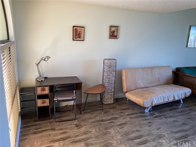
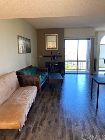
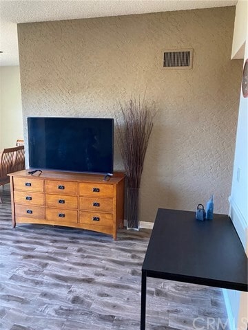
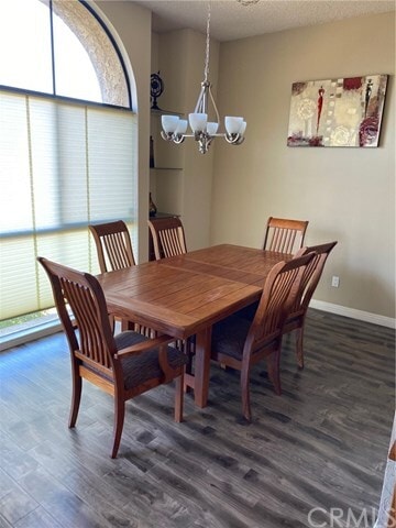
AMAZING VIEW!!!!!! Located in the Monterey Hills neighborhood features picturesque views, tree-lined surroundings and genuine neighborhood camaraderie. This hilltop townhouse in the desirable Vallejo Villas complex boasts a dramatic view of Elephant Hill and South Pasadena. Enjoy this view from the balcony! The living room, dining room, updated kitchen, laundry room, half bath, an extra den area and direct garage access are all located on the main floor. With high ceilings and skylights, this level receives lots of natural light. Downstairs you'll find two bedroom suites both furnished with queen size beds. The unit also comes with two sofas, coffee table, one dresser, two flat screen televisions, a side table, a dining table, one desk, elliptical machine, refrigerator, stove, dish. MOVE IN READY!!!
650 Vallejo Villas St is a townhome located in Los Angeles County and the 90042 ZIP Code. This area is served by the Los Angeles Unified attendance zone.
Townhome Features
- Furnished
Location
Get Directions
A quiet suburb outside of Los Angeles, Monterey Hills is known for its rolling hills, winding residential streets, and elevated city views. Check out Elephant Hill, a popular place to bike or hike that offers beautiful views of the neighborhood. Herman Park is nestled along Highway 110 in the north end of the neighborhood, offering tennis courts, playgrounds, and a dog park. And for more outdoor recreation, visit the biking paths and hiking trails at Ernest E. Debs Regional Park, bordering Monterey Hills.
Monterey Hills is a more secluded part of Northeast Los Angeles with larger lots, single-family homes, and tree-lined streets. However, if you cross over Highway 110, you’ll find theatres, restaurants, services, and more. Monterey Hills is located just seven miles northeast of Downtown Los Angeles and eight miles east of major attractions such as Griffith Park, the Los Angeles Zoo, the Greek Theatre, and Glendale Galleria.
Learn more about living in Monterey HillsBelow are rent ranges for similar nearby apartments
| Beds | Average Size | Lowest | Typical | Premium |
|---|---|---|---|---|
| Studio Studio Studio | 440 Sq Ft | $1,750 | $1,880 | $1,989 |
| 1 Bed 1 Bed 1 Bed | 703-708 Sq Ft | $1,900 | $2,142 | $2,864 |
| 2 Beds 2 Beds 2 Beds | 903-904 Sq Ft | $1,032 | $2,710 | $4,750 |
| 3 Beds 3 Beds 3 Beds | 1208 Sq Ft | $2,800 | $4,159 | $7,000 |
| 4 Beds 4 Beds 4 Beds | 1269 Sq Ft | $1,000 | $4,072 | $10,500 |
Amenities
- Furnished
Education
| Colleges & Universities | Distance | ||
|---|---|---|---|
| Colleges & Universities | Distance | ||
| Drive: | 8 min | 3.6 mi | |
| Drive: | 10 min | 4.0 mi | |
| Drive: | 10 min | 4.0 mi | |
| Drive: | 8 min | 4.4 mi |
650 Vallejo Villas St is within 10 minutes or 4.0 miles from Cal State Los Angeles. It is also near USC, Health Sciences Campus and Occidental College.
Schools


Charter Elementary School
Grades K-5
75 Students
Nearby
Public Elementary School
Grades K-5
181 Students
Attendance Zone
Public Middle School
Grades 6-8
904 Students
Attendance Zone
Public High School
Grades 9-12
1,028 Students
Attendance Zone
Public High School
Grades 9-12
1,406 Students
Attendance Zone
Private Elementary School
Grades PK-5
131 Students
Nearby
Private Elementary, Middle & High School
Grades K-12
93 Students
Nearby
Private Elementary & Middle School
Grades K-8
Nearby
School data provided by
 The GreatSchools Rating helps parents compare schools within a state based on a variety of school quality indicators and provides a helpful picture of how effectively each school serves all of its students. Ratings are on a scale of 1 (below average) to 10 (above average) and can include test scores, college readiness, academic progress, advanced courses, equity, discipline and attendance data. We also advise parents to visit schools, consider other information on school performance and programs, and consider family needs as part of the school selection process.
View GreatSchools Rating Methodology
Data provided by GreatSchools.org © 2025. All rights reserved.
View GreatSchools Rating Methodology
Data provided by GreatSchools.org © 2025. All rights reserved.
Transportation options available in Los Angeles include Highland Park Station, located 1.8 miles from 650 Vallejo Villas St. 650 Vallejo Villas St is near Bob Hope, located 18.2 miles or 26 minutes away, and Los Angeles International, located 21.3 miles or 34 minutes away.
| Transit / Subway | Distance | ||
|---|---|---|---|
| Transit / Subway | Distance | ||
|
|
Drive: | 5 min | 1.8 mi |
|
|
Drive: | 7 min | 3.0 mi |
|
|
Drive: | 7 min | 3.3 mi |
|
|
Drive: | 6 min | 3.4 mi |
|
|
Drive: | 7 min | 4.0 mi |
| Commuter Rail | Distance | ||
|---|---|---|---|
| Commuter Rail | Distance | ||
|
|
Drive: | 12 min | 5.1 mi |
|
|
Drive: | 11 min | 5.2 mi |
|
|
Drive: | 13 min | 7.5 mi |
| Drive: | 14 min | 9.1 mi | |
|
|
Drive: | 20 min | 9.9 mi |
| Airports | Distance | ||
|---|---|---|---|
| Airports | Distance | ||
|
Bob Hope
|
Drive: | 26 min | 18.2 mi |
|
Los Angeles International
|
Drive: | 34 min | 21.3 mi |
Time and distance from 650 Vallejo Villas St.
| Shopping Centers | Distance | ||
|---|---|---|---|
| Shopping Centers | Distance | ||
| Drive: | 4 min | 1.6 mi | |
| Drive: | 5 min | 2.1 mi | |
| Drive: | 5 min | 2.2 mi |
650 Vallejo Villas St has 3 shopping centers within 2.2 miles, which is about a 5-minute drive. The miles and minutes will be for the farthest away property.
| Parks and Recreation | Distance | ||
|---|---|---|---|
| Parks and Recreation | Distance | ||
|
Audubon Center at Debs Park
|
Drive: | 5 min | 2.3 mi |
|
Chavez Ravine Arboretum
|
Drive: | 10 min | 5.9 mi |
|
Elysian Park
|
Drive: | 13 min | 6.0 mi |
|
Elyria Canyon Park
|
Drive: | 12 min | 6.2 mi |
|
Marsh Park
|
Drive: | 13 min | 6.6 mi |
650 Vallejo Villas St has 5 parks within 6.6 miles, including Audubon Center at Debs Park, Elyria Canyon Park, and Elysian Park.
| Hospitals | Distance | ||
|---|---|---|---|
| Hospitals | Distance | ||
| Drive: | 7 min | 3.3 mi | |
| Drive: | 8 min | 3.4 mi | |
| Drive: | 8 min | 4.1 mi |
650 Vallejo Villas St has 3 hospitals within 4.1 miles, the nearest is Keck Hospital of USC which is 3.3 miles away and a 7 minute drive.
| Military Bases | Distance | ||
|---|---|---|---|
| Military Bases | Distance | ||
| Drive: | 31 min | 22.8 mi | |
| Drive: | 42 min | 26.8 mi |
650 Vallejo Villas St is 22.8 miles from Los Angeles Air Force Base, and is convenient to other military bases, including Los Alamitos Army Airfield.
You May Also Like
Similar Rentals Nearby
-
-
-
-
1 / 50

-
-
-
-
-
-


What Are Walk Score®, Transit Score®, and Bike Score® Ratings?
Walk Score® measures the walkability of any address. Transit Score® measures access to public transit. Bike Score® measures the bikeability of any address.
What is a Sound Score Rating?
A Sound Score Rating aggregates noise caused by vehicle traffic, airplane traffic and local sources

650 Vallejo Villas St
Los Angeles, CA 90042