
$5,600 / Month
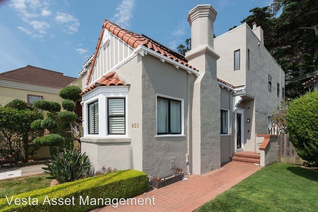
650 Sloat Blvd
San Francisco, CA 94132
2 Weeks Ago
Favorites
650 Sloat Blvd

Favorites
Check Back Soon for Upcoming Availability
| Beds | Baths | Average SF |
|---|---|---|
| 3 Bedrooms 3 Bedrooms 3 Br | 2.5 Baths 2.5 Baths 2.5 Ba | 1,927 SF |
About This Property
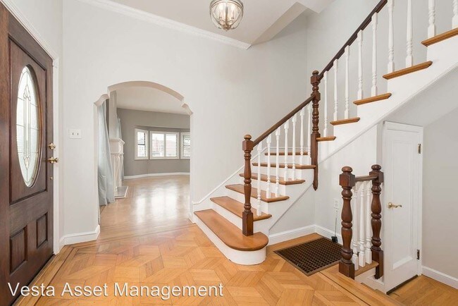
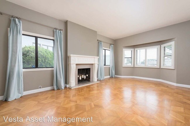
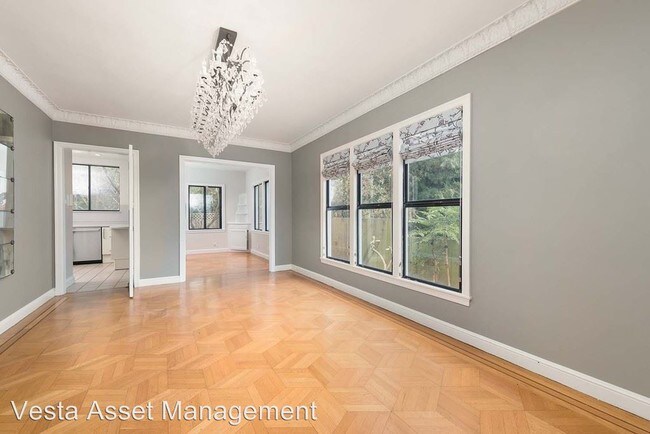
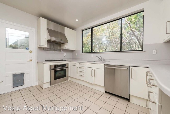
(415) 828-5080 x5080 - SPACIOUS FULLY DETACHED 3BR/2.5BA SINGLE FAMILY HOME OVERLOOKING STERN GROVE PARK - 650 Sloat Boulevard 3BR/2.5BA Single Family Home $5,600 LARGE LIGHT FILLED LIVING ROOM *Parquet Wood Flooring, Triple Front Windows *Wood Burning Fireplace FORMAL DINING ROOM / SEPARATE FAMILY ROOM *Both with Hardwood Flooring LARGE UPDATED KITCHEN WITH DINING NOOK *Stainless Steel Gas Range/Oven w/Exhaust Hood, Refrigerator and Dishwasher, Tile Flooring *Generous Counter Space and Generous Cabinetry *POWDER ROOM completes the first floor MASTER BEDROOM SUITE *Large Private Bath with jacuzzi Tub *Private Deck overlooking Stern Grove park TWO MORE BEDROOMS SECOND FULL BATH PRIVATE YARD ONE CAR ATTACHED GARAGE WASHER/DRYER IN HOME PET FRIENDLY LOCATION LOCATION! "ln the Highly Desirable Merced Manor neighborhood *The back of the home overlooks Stern Grove/Pine lake Park *Direct access into the park through the backyard. *Close to West Portal Shops & Restaurants, Stonestown Mall *Close to Muni Street Car K, L and M lines *Close to 19th/Ave and 280 for fast access North and South PLEASE NOTE: Home is tenant occupied through May 31st. THE FIRST SHOWINGS ARE SATURDAY JUNE 1ST AT 4:00 AND SUNDAY JUNE 2ND AT 1:30 Please be there promptly at the viewing time either day to view. Please email me with any questions One Year Lease, Security Deposit 1.5 times Rent. Application Fee $40 per Adult. Renter's Insurance Required Tenants Pay All Utilities Michelle McCullough, Broker Director of Leasing, Vesta Asset Management, Inc. www.vesta-assetmanagement.com michelle@vesta-assetmanagement.com Member SFAA, CAR, NAR, SFAR BRE #0172367 415.828.5080 (RLNE4891208)
650 Sloat Blvd is a house located in San Francisco County and the 94132 ZIP Code. This area is served by the San Francisco Unified attendance zone.
Location
Get Directions
Central Sunset is a densely populated area about one mile east of the beach and five miles west of the heart of San Francisco. Renters have a large selection of apartments, single-family homes, and condos to choose from. Central Sunset’s residential neighborhoods are paired with parks like Stern Grove Park and McCoppin Square. For in-town shopping and dining, residents head to Taraval Street, Irving Street, and Noriega Street. A variety of eateries serving everything from seafood and barbecue can be found along these roads. This Bay Area suburb is also in proximity to the world-renowned dining, shopping, and entertainment offered by Downtown San Francisco and its neighboring cities.
Learn more about living in Central SunsetBelow are rent ranges for similar nearby apartments
Education
| Colleges & Universities | Distance | ||
|---|---|---|---|
| Colleges & Universities | Distance | ||
| Drive: | 3 min | 1.2 mi | |
| Drive: | 7 min | 2.3 mi | |
| Drive: | 8 min | 3.0 mi | |
| Drive: | 11 min | 4.6 mi |
650 Sloat Blvd is within 3 minutes or 1.2 miles from San Francisco State University. It is also near City College of San Francisco and UC San Francisco, Parnassus.
Schools


Public Elementary School
Grades K-5
394 Students
Nearby
Public Elementary School
Grades K-5
Nearby
Public Middle School
Grades 6-8
848 Students
Nearby
Public High School
Grades 9-12
2,632 Students
Nearby
Private Elementary & Middle School
Grades PK-8
293 Students
Nearby
Private Elementary, Middle & High School
Grades PK-12
481 Students
Nearby
Private Elementary & Middle School
Grades PK-8
131 Students
Nearby
School data provided by
 The GreatSchools Rating helps parents compare schools within a state based on a variety of school quality indicators and provides a helpful picture of how effectively each school serves all of its students. Ratings are on a scale of 1 (below average) to 10 (above average) and can include test scores, college readiness, academic progress, advanced courses, equity, discipline and attendance data. We also advise parents to visit schools, consider other information on school performance and programs, and consider family needs as part of the school selection process.
View GreatSchools Rating Methodology
Data provided by GreatSchools.org © 2025. All rights reserved.
View GreatSchools Rating Methodology
Data provided by GreatSchools.org © 2025. All rights reserved.
Transportation options available in San Francisco include West Portal/Sloat/St Francis Circle, located 0.4 mile from 650 Sloat Blvd. 650 Sloat Blvd is near San Francisco International, located 12.4 miles or 20 minutes away, and Metro Oakland International, located 26.7 miles or 41 minutes away.
| Transit / Subway | Distance | ||
|---|---|---|---|
| Transit / Subway | Distance | ||
| Walk: | 8 min | 0.4 mi | |
|
|
Walk: | 8 min | 0.4 mi |
|
|
Walk: | 9 min | 0.5 mi |
|
|
Walk: | 9 min | 0.5 mi |
| Walk: | 9 min | 0.5 mi |
| Commuter Rail | Distance | ||
|---|---|---|---|
| Commuter Rail | Distance | ||
| Drive: | 12 min | 6.1 mi | |
| Drive: | 12 min | 7.1 mi | |
| Drive: | 12 min | 7.2 mi | |
| Drive: | 14 min | 8.0 mi | |
| Drive: | 14 min | 8.0 mi |
| Airports | Distance | ||
|---|---|---|---|
| Airports | Distance | ||
|
San Francisco International
|
Drive: | 20 min | 12.4 mi |
|
Metro Oakland International
|
Drive: | 41 min | 26.7 mi |
Time and distance from 650 Sloat Blvd.
| Shopping Centers | Distance | ||
|---|---|---|---|
| Shopping Centers | Distance | ||
| Walk: | 13 min | 0.7 mi | |
| Walk: | 15 min | 0.8 mi | |
| Drive: | 5 min | 1.5 mi |
650 Sloat Blvd has 3 shopping centers within 1.5 miles, which is about a 5-minute walk. The miles and minutes will be for the farthest away property.
| Parks and Recreation | Distance | ||
|---|---|---|---|
| Parks and Recreation | Distance | ||
|
San Francisco Zoo
|
Drive: | 4 min | 1.5 mi |
|
San Francisco State Univ. Observatory
|
Drive: | 5 min | 1.7 mi |
|
Charles F. Hagar Planetarium
|
Drive: | 5 min | 1.7 mi |
|
San Francisco Botanical Garden
|
Drive: | 7 min | 2.7 mi |
|
Golden Gate Park
|
Drive: | 9 min | 3.2 mi |
650 Sloat Blvd has 5 parks within 3.2 miles, including San Francisco State Univ. Observatory, Charles F. Hagar Planetarium, and San Francisco Zoo.
| Hospitals | Distance | ||
|---|---|---|---|
| Hospitals | Distance | ||
| Drive: | 4 min | 1.6 mi | |
| Drive: | 8 min | 3.1 mi | |
| Drive: | 8 min | 3.1 mi |
650 Sloat Blvd has 3 hospitals within 3.1 miles, the nearest is Laguna Honda Hospital & Rehabilitation Center which is 1.6 miles away and a 4 minute drive.
| Military Bases | Distance | ||
|---|---|---|---|
| Military Bases | Distance | ||
| Drive: | 14 min | 4.8 mi | |
| Drive: | 13 min | 4.9 mi |
650 Sloat Blvd is 4.8 miles from East Fort Miley, and is convenient to other military bases, including West Fort Miley.
You May Also Like
Similar Rentals Nearby


What Are Walk Score®, Transit Score®, and Bike Score® Ratings?
Walk Score® measures the walkability of any address. Transit Score® measures access to public transit. Bike Score® measures the bikeability of any address.
What is a Sound Score Rating?
A Sound Score Rating aggregates noise caused by vehicle traffic, airplane traffic and local sources

650 Sloat Blvd
San Francisco, CA 94132