
$1,395
/ Month
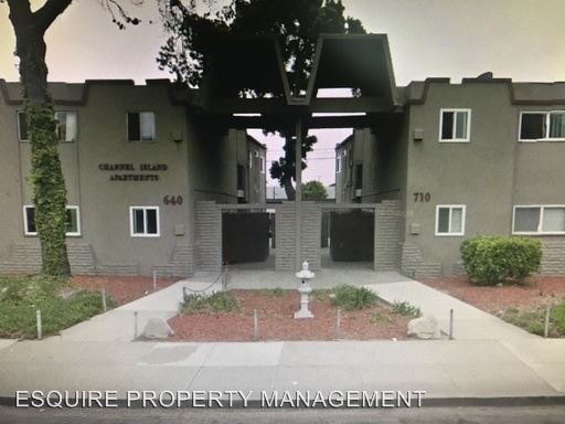
640 W Channel Islands Blvd
Oxnard, CA 93033
2 Weeks Ago
|
Edit
Favorites
640 W Channel Islands Blvd

Favorites
Check Back Soon for Upcoming Availability
| Beds | Baths | Average SF |
|---|---|---|
| 2 Bedrooms 2 Bedrooms 2 Br | 1 Bath 1 Bath 1 Ba | — |
About This Property
(805) 482-3209 - 2 BD / 1 BATH Oxnard Unit - Large apartment complex with onsite manager. 1 covered parking spot per unit. Includes water/ sewer / trash. Available 2/14/2017. No Pets. No Pets Allowed (RLNE2490956) Appliances - Range. Pet policies - No Dogs Allowed, No Cats Allowed.
640 W Channel Islands Blvd is a condo located in Ventura County and the 93033 ZIP Code.
640 W Channel Islands Blvd,
Oxnard,
CA
93033
Kamala Park is a largely residential neighborhood filled with schools, churches, shopping, dining, and parks. Notable neighborhood attractions include Durley Park, Rudolph Beck Memorial Park, and Centerpoint Mall. Just north of Kamala Park is the Oxnard Performing Arts Center which is located between Oxnard Community Park and Community Center Park. Oxnard Beach Park and Naval Construction Battalion Center Port Hueneme are just short drives from Kamala Park.
Traveling and commuting from Kamala Park is simple with convenient access to Oxnard Airport, Downtown Oxnard, multiple city bus routes, and the Pacific Coast Highway.
Learn more about living in Kamala ParkBelow are rent ranges for similar nearby apartments
Education
| Colleges & Universities | Distance | ||
|---|---|---|---|
| Colleges & Universities | Distance | ||
| Drive: | 6 min | 2.4 mi | |
| Drive: | 14 min | 9.6 mi | |
| Drive: | 18 min | 10.2 mi | |
| Drive: | 35 min | 23.6 mi |
640 W Channel Islands Blvd is within 6 minutes or 2.4 miles from Oxnard College. It is also near CSU Channel Islands and Ventura College.
Walkability Near 640 W Channel Islands Blvd Oxnard, CA 93033
Getting Around
 What do Walkability, Transit, Drivability, and Bikeability mean?
Walkability measures the walking distance to day-to-day needs.
Transit measures access to public transportation.
Drivability measures congestion, parking availability, and access to major roads.
Bikeability measures the suitability for cycling.
How It Works
What do Walkability, Transit, Drivability, and Bikeability mean?
Walkability measures the walking distance to day-to-day needs.
Transit measures access to public transportation.
Drivability measures congestion, parking availability, and access to major roads.
Bikeability measures the suitability for cycling.
How It Works
Fairly Walkable
Walkability
50
/ 100
Some Public Transit
Transit
50
/ 100
Exceptionally Drivable
Drivability
90
/ 100
Moderately Bikeable
Bikeability
60
/ 100
Scores provided by
-
Soundscore™
-
/ 100
Traffic
-Airport
-Businesses
-Scores provided by
HowLoud What is a Sound Score Rating? A Sound Score Rating aggregates noise caused by vehicle traffic, airplane traffic and local sources. How It WorksYou May Also Like
Similar Rentals Nearby
-
-

-
 2 Beds, 2 Baths, 967 sq ft$2,750207 W Channel Islands Blvd Unit 207
 -

-
 3 Beds, 2 Baths, 987 sq ft$3,395225 S Ventura Rd Unit 79
 -

-

-
 2 Beds, 2 Baths, 942 sq ft$3,250Total Monthly Price12 Month LeaseTotal Monthly Price NewPrices include all required monthly fees.787 Reef Cir
 -

-

What Are Walk Score®, Transit Score®, and Bike Score® Ratings?
Walk Score® measures the walkability of any address. Transit Score® measures access to public transit. Bike Score® measures the bikeability of any address.
What is a Sound Score Rating?
A Sound Score Rating aggregates noise caused by vehicle traffic, airplane traffic and local sources.
640 W Channel Islands Blvd
Oxnard, CA 93033