
$2,350
/ Month
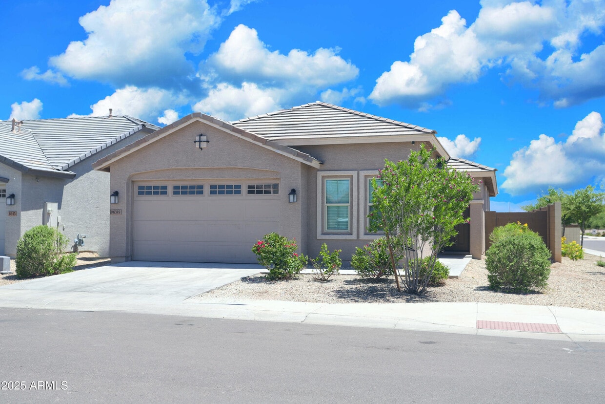
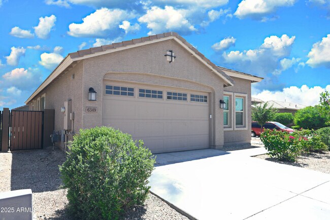
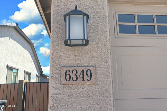
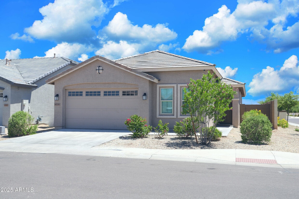
6349 W Raymond St
Phoenix, AZ 85043
Today
Favorites
480-678-2450
-
Bedrooms
4
-
Bathrooms
2
-
Square Feet
1,800 sq ft
-
Available
Available Now
Highlights
- Double Vanity
- Breakfast Bar
- Central Air
- ENERGY STAR Qualified Equipment for Heating
- Carpet
- Vinyl Flooring
6349 W Raymond St

Favorites
About This Home
$2,500 deposit,
Available Now
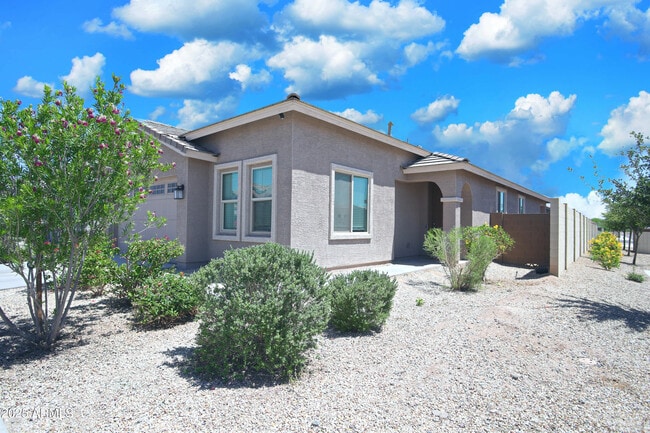
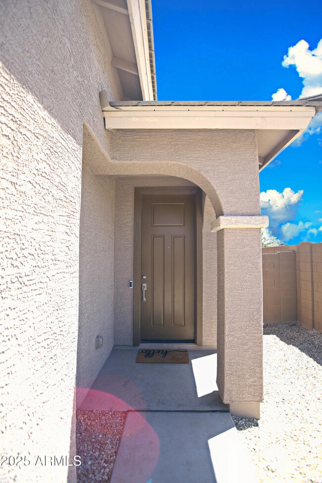
Location! Location! Almost New home with 4 bedroom,2 full bathroom single level central Phoenix home located close to Freeway 202. This amazing home includes large open living room,Upgraded tile all over except bedrooms. Kitchen features quartz counter tops,large island,breakfast bar,Stainless Steel gas range,stove top microwave,dishwasher,refrigerator,separate pantry and upgraded cabinets washer and dryer. Large master suite with walk-in closet,double sink vanity and large shower. ALL NEW VINYL FLOORING,NO CARPETS,FRESH PAINT,Community for privacy. Easy to maintain desert landscaping,covered patio in backyard and soon to be added landscaping. .
6349 W Raymond St is a house located in Maricopa County and the 85043 ZIP Code. This area is served by the Riverside Elementary District attendance zone.
* Price shown is base rent and may not include non-optional fees and utilities. Price, availability, fees, and any applicable rent special are subject to change without notice.
* Square footage definitions vary. Displayed square footage is approximate.
Home Details
Year Built
Built in 2021
Bedrooms and Bathrooms
Primary Bathroom is a Full Bathroom
Double Vanity
2 Bathrooms
4 Bedrooms
Bathtub With Separate Shower Stall
Eco-Friendly Details
ENERGY STAR Qualified Equipment for Heating
Flooring
Carpet
Vinyl
Home Design
Tile Roof
Stucco
Wood Frame Construction
Interior Spaces
1,800 Sq Ft Home
1-Story Property
Kitchen
Breakfast Bar
Gas Cooktop
Built-In Microwave
Laundry
Dryer
Washer
Listing and Financial Details
Property Available on 5/24/25
$50 Move-In Fee
12-Month Minimum Lease Term
$50 Application Fee
Tax Lot 79
Assessor Parcel Number 104-56-555
Lot Details
5,544 Sq Ft Lot
Desert faces the front of the property
Block Wall Fence
Parking
2 Car Garage
Schools
Riverside Elementary School District Stem2 Online Sch
Maricopa Institute Of Technology Middle School
Betty Fairfax High School
Utilities
Central Air
Heating Available
Community Details
Overview
Property has a Home Owners Association
Village At Estrella Association
Built by LENNAR
Village At Estrella Subdivision
Contact
- Listed by Biman Saha | Air One Realty LLC
- Phone Number
- Contact
-
Source
Arizona Regional MLS
Copyright 2025 Arizona Regional MLS. All rights reserved. Information is deemed reliable but not guaranteed.
Location
Get Directions
Located about ten miles west of Downtown Phoenix, Estrella offers residents a suburban atmosphere within minutes of a wide variety of amenities. Estrella offers plenty of shopping options at the Tuscano Towne Center and the nearby Desert Sky Mall in addition to numerous dining opportunities along West Van Buren Street.
Bordering the Salt River, Estrella provides ample possibilities for outdoor recreation, with convenience to Cesar Chavez Park, South Mountain Park, and Estrella Mountain Regional Park. Estrella is also just a short drive away from major attractions like the Arizona State Fair, Ak-Chin Pavilion, and ISM Raceway. Quick access to I-10 and I-17 puts Estrella within close proximity to much of the Greater Phoenix area.
Learn more about living in Estrella
Education
| Colleges & Universities | Distance | ||
|---|---|---|---|
| Colleges & Universities | Distance | ||
| Drive: | 21 min | 10.8 mi | |
| Drive: | 17 min | 11.4 mi | |
| Drive: | 18 min | 11.7 mi | |
| Drive: | 20 min | 11.8 mi |
6349 W Raymond St is within 18 minutes or 11.7 miles from Arizona State Univ., Downtown. It is also near University of Arizona and Grand Canyon University.
Schools


Public Elementary & Middle School
Grades 5-8
353 Students
Attendance Zone
Public Elementary School
Grades PK-4
400 Students
Attendance Zone
Public High School
Grades 9-12
1,973 Students
Attendance Zone
Private Elementary & Middle School
Grades 3-8
Nearby
Private Elementary School
Grades PK-4
Nearby
Private High School
Grades 9-12
192 Students
Nearby
School data provided by
 The GreatSchools Rating helps parents compare schools within a state based on a variety of school quality indicators and provides a helpful picture of how effectively each school serves all of its students. Ratings are on a scale of 1 (below average) to 10 (above average) and can include test scores, college readiness, academic progress, advanced courses, equity, discipline and attendance data. We also advise parents to visit schools, consider other information on school performance and programs, and consider family needs as part of the school selection process.
View GreatSchools Rating Methodology
Data provided by GreatSchools.org © 2025. All rights reserved.
View GreatSchools Rating Methodology
Data provided by GreatSchools.org © 2025. All rights reserved.
Transportation options available in Phoenix include Van Buren/1St Ave, located 10.8 miles from 6349 W Raymond St. 6349 W Raymond St is near Phoenix Sky Harbor International, located 16.4 miles or 25 minutes away, and Phoenix-Mesa Gateway, located 38.3 miles or 50 minutes away.
| Transit / Subway | Distance | ||
|---|---|---|---|
| Transit / Subway | Distance | ||
|
|
Drive: | 17 min | 10.8 mi |
|
|
Drive: | 17 min | 11.0 mi |
|
|
Drive: | 17 min | 11.1 mi |
|
|
Drive: | 18 min | 11.3 mi |
|
|
Drive: | 18 min | 12.0 mi |
| Commuter Rail | Distance | ||
|---|---|---|---|
| Commuter Rail | Distance | ||
|
|
Drive: | 48 min | 36.7 mi |
| Airports | Distance | ||
|---|---|---|---|
| Airports | Distance | ||
|
Phoenix Sky Harbor International
|
Drive: | 25 min | 16.4 mi |
|
Phoenix-Mesa Gateway
|
Drive: | 50 min | 38.3 mi |
Time and distance from 6349 W Raymond St.
| Shopping Centers | Distance | ||
|---|---|---|---|
| Shopping Centers | Distance | ||
| Drive: | 5 min | 2.1 mi | |
| Drive: | 5 min | 2.3 mi | |
| Drive: | 5 min | 2.4 mi |
6349 W Raymond St has 3 shopping centers within 2.4 miles, which is about a 5-minute drive. The miles and minutes will be for the farthest away property.
| Parks and Recreation | Distance | ||
|---|---|---|---|
| Parks and Recreation | Distance | ||
|
El Oso Park
|
Drive: | 13 min | 6.8 mi |
|
Alkire Park
|
Drive: | 15 min | 7.5 mi |
|
Maryvale Park
|
Drive: | 15 min | 7.6 mi |
|
Colter Park
|
Drive: | 14 min | 7.7 mi |
|
Base and Meridian Wildlife Area
|
Drive: | 15 min | 8.5 mi |
6349 W Raymond St has 5 parks within 8.5 miles, including El Oso Park, Maryvale Park, and Alkire Park.
| Hospitals | Distance | ||
|---|---|---|---|
| Hospitals | Distance | ||
| Drive: | 8 min | 4.1 mi | |
| Drive: | 14 min | 8.2 mi | |
| Drive: | 16 min | 8.2 mi |
6349 W Raymond St has 3 hospitals within 8.2 miles, the nearest is Dignity Health - Arizona General Hospital which is 4.1 miles away and a 8 minute drive.
| Military Bases | Distance | ||
|---|---|---|---|
| Military Bases | Distance | ||
| Drive: | 25 min | 12.5 mi | |
| Drive: | 27 min | 17.4 mi | |
| Drive: | 95 min | 70.0 mi |
6349 W Raymond St has 3 military bases within 70.0 miles, the nearest is Phoenix Sky Harbor Airport Air Guard Station which is 12.5 miles away and a 25 minute drive.
You May Also Like
Similar Rentals Nearby
-
-

-

-
-
-
1 / 21

-
-

-

-


What Are Walk Score®, Transit Score®, and Bike Score® Ratings?
Walk Score® measures the walkability of any address. Transit Score® measures access to public transit. Bike Score® measures the bikeability of any address.
What is a Sound Score Rating?
A Sound Score Rating aggregates noise caused by vehicle traffic, airplane traffic and local sources
6349 W Raymond St
Phoenix, AZ 85043