

$5,000
/ Month
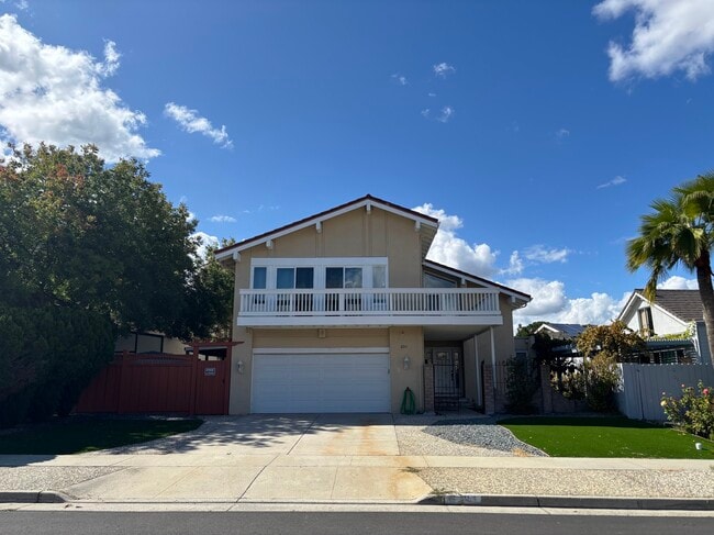
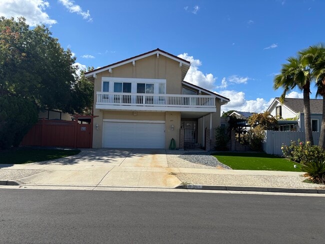
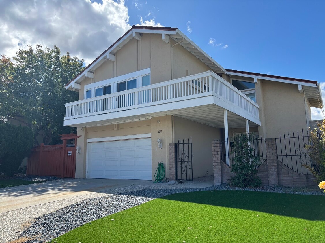
6311 Benzo Dr
San Jose, CA 95123
Today
|
Edit
Favorites
408-598-7830
-
Bedrooms
4
-
Bathrooms
2.25
-
Square Feet
1,848 sq ft
-
Available
Available Now
6311 Benzo Dr

Favorites
About This Home
$5,000 deposit,
Available Now
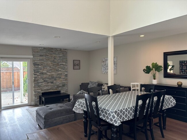
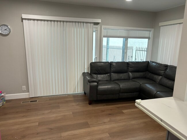
One of the best locations in San Jose, nestled up Close to the Santa Teresa Foothills, very quiet neighborhood. There's a wrap-around balcony that leads through double doors to the primary bedroom. The home has been recently remodeled. This is a perfect home for entertaining and for a bigger family.
6311 Benzo Dr is a house located in Santa Clara County and the 95123 ZIP Code. This area is served by the Oak Grove Elementary attendance zone.
* Price shown is base rent. Excludes user-selected optional fees and variable or usage-based fees and required charges due at or prior to move-in or at move-out. Price, availability, fees, and any applicable rent special are subject to change without notice.
* Square footage definitions vary. Displayed square footage is approximate.
Fees and Policies
The fees below are based on community-supplied data and may exclude additional fees and utilities.
- One-Time Basics
- Due at Move-In
- Security Deposit - Refundable$5,000
- Due at Move-In
Property Fee Disclaimer: Based on community-supplied data and independent market research. Subject to change without notice. May exclude fees for mandatory or optional services and usage-based utilities.
House Features
- Dishwasher
- Refrigerator
- Balcony
Contact
- Listed by John Hanna
- Phone Number
- Contact
Location
Get Directions
Amenities
- Dishwasher
- Refrigerator
- Balcony
Blossom Valley is a neighborhood in San Jose situated along Highway 85 between the Sierra Azul Preserve and the Diablo Range. The neighborhood is densely populated with several apartments and a few spacious homes for rent. An abundance of shopping and dining options at large retail centers like Westfield Oakridge are located in town as well. More retailers and eateries are scattered throughout the neighborhood, and a few community parks like Comanche Lookout Park dot the area. Parks, golf courses, and trails surround Blossom Valley, and outdoor enthusiasts have easy access to the massive state parks on either side of town.
Learn more about living in Blossom Valley/S San Jose
Education
| Colleges & Universities | Distance | ||
|---|---|---|---|
| Colleges & Universities | Distance | ||
| Drive: | 18 min | 8.3 mi | |
| Drive: | 19 min | 11.1 mi | |
| Drive: | 19 min | 11.8 mi | |
| Drive: | 23 min | 13.9 mi |
6311 Benzo Dr is within 18 minutes or 8.3 miles from Evergreen Valley College. It is also near San Jose State University and San Jose City College.
Schools


Public Elementary School
Grades K-6
529 Students
Attendance Zone
Public Elementary School
Grades K-5
528 Students
Nearby
Public Middle School
Grades 7-8
636 Students
Attendance Zone
Public High School
Grades 9-12
2,196 Students
Attendance Zone
Private Elementary & Middle School
Grades PK-8
173 Students
Nearby
Private Elementary, Middle & High School
Grades K-12
202 Students
Nearby
School data provided by
 The GreatSchools Rating helps parents compare schools within a state based on a variety of school quality indicators and provides a helpful picture of how effectively each school serves all of its students. Ratings are on a scale of 1 (below average) to 10 (above average) and can include test scores, college readiness, academic progress, advanced courses, equity, discipline and attendance data. We also advise parents to visit schools, consider other information on school performance and programs, and consider family needs as part of the school selection process.
View GreatSchools Rating Methodology
Data provided by GreatSchools.org © 2025. All rights reserved.
View GreatSchools Rating Methodology
Data provided by GreatSchools.org © 2025. All rights reserved.
Transportation options available in San Jose include Santa Teresa Station, located 2.0 miles from 6311 Benzo Dr. 6311 Benzo Dr is near Norman Y Mineta San Jose International, located 13.3 miles or 21 minutes away.
| Transit / Subway | Distance | ||
|---|---|---|---|
| Transit / Subway | Distance | ||
|
|
Drive: | 6 min | 2.0 mi |
|
|
Drive: | 6 min | 3.2 mi |
| Drive: | 6 min | 3.2 mi | |
|
|
Drive: | 8 min | 4.1 mi |
| Drive: | 9 min | 5.3 mi |
| Commuter Rail | Distance | ||
|---|---|---|---|
| Commuter Rail | Distance | ||
| Drive: | 7 min | 2.8 mi | |
| Drive: | 11 min | 5.6 mi | |
| Drive: | 16 min | 9.0 mi | |
| Drive: | 16 min | 9.1 mi | |
| Drive: | 17 min | 10.4 mi |
| Airports | Distance | ||
|---|---|---|---|
| Airports | Distance | ||
|
Norman Y Mineta San Jose International
|
Drive: | 21 min | 13.3 mi |
Time and distance from 6311 Benzo Dr.
| Shopping Centers | Distance | ||
|---|---|---|---|
| Shopping Centers | Distance | ||
| Walk: | 17 min | 0.9 mi | |
| Walk: | 19 min | 1.0 mi | |
| Drive: | 5 min | 1.7 mi |
6311 Benzo Dr has 3 shopping centers within 1.7 miles, which is about a 5-minute walk. The miles and minutes will be for the farthest away property.
| Parks and Recreation | Distance | ||
|---|---|---|---|
| Parks and Recreation | Distance | ||
|
Santa Teresa County Park
|
Drive: | 12 min | 3.7 mi |
|
Almaden Lake Park
|
Drive: | 8 min | 3.9 mi |
|
Coyote Creek Parkway
|
Drive: | 10 min | 5.3 mi |
|
Hellyer County Park
|
Drive: | 12 min | 5.5 mi |
|
Almaden Quicksilver County Park
|
Drive: | 16 min | 6.9 mi |
6311 Benzo Dr has 5 parks within 6.9 miles, including Santa Teresa County Park, Almaden Lake Park, and Hellyer County Park.
| Hospitals | Distance | ||
|---|---|---|---|
| Hospitals | Distance | ||
| Drive: | 3 min | 1.2 mi | |
| Drive: | 7 min | 3.6 mi | |
| Drive: | 15 min | 9.4 mi |
6311 Benzo Dr has 3 hospitals within 9.4 miles, the nearest is Kaiser Foundation Hospital - San Jose which is 1.2 miles away and a 3 minute drive.
| Military Bases | Distance | ||
|---|---|---|---|
| Military Bases | Distance | ||
| Drive: | 32 min | 22.4 mi |
6311 Benzo Dr is 22.4 miles and a 32 minute drive from Ames Research Center.
You May Also Like
Similar Rentals Nearby


What Are Walk Score®, Transit Score®, and Bike Score® Ratings?
Walk Score® measures the walkability of any address. Transit Score® measures access to public transit. Bike Score® measures the bikeability of any address.
What is a Sound Score Rating?
A Sound Score Rating aggregates noise caused by vehicle traffic, airplane traffic and local sources
6311 Benzo Dr
San Jose, CA 95123