

$2,495 / Month
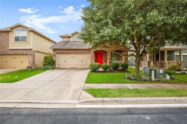
630 W 34th St
Austin, TX 78705
2 Weeks Ago
Favorites
630 W 34th St

Favorites
Check Back Soon for Upcoming Availability
| Beds | Baths | Average SF |
|---|---|---|
| 3 Bedrooms 3 Bedrooms 3 Br | 3 Baths 3 Baths 3 Ba | 2,019 SF |
Fees and Policies
The fees below are based on community-supplied data and may exclude additional fees and utilities.
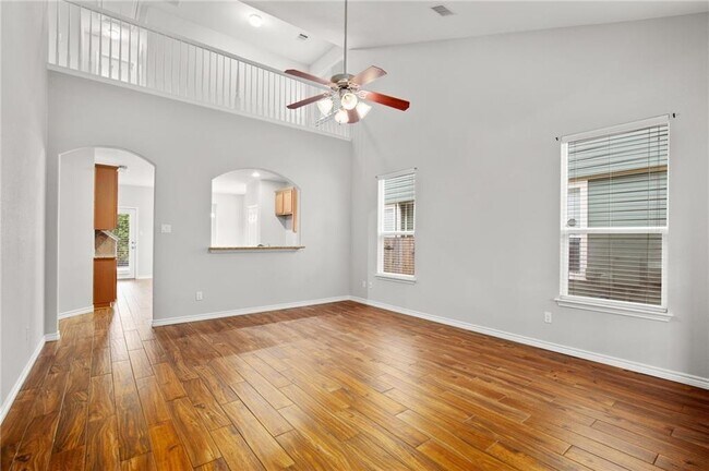
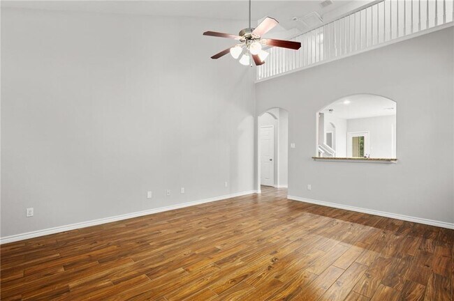
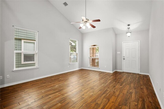
About This Property
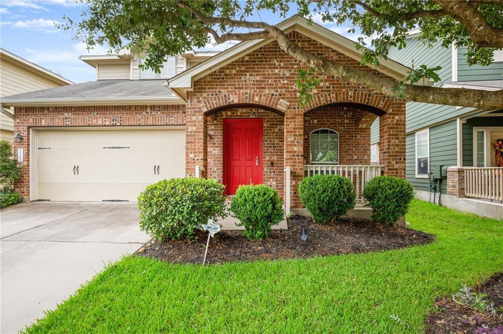
Beautiful 3 bedroom, 3 bath home with multiple living areas! Includes refrigerator. This home is impeccably clean & maintained with a peaceful outdoor oasis to enjoy that morning cup of joe & glass wine in the evening! Come unwind in this quaint neighborhood. Close to everything in South Austin including beautiful Mary Moore Searight Park, HEB (less than a mile), Moontower, coffee shops, restaurants etc. All Northpoint Asset Management residents are enrolled in the Resident Benefits Package (RBP) for $50/month which includes renters insurance, HVAC air filter delivery (for applicable properties), credit building to help boost your credit score with timely rent payments, $1M Identity Protection, move-in concierge service making utility connection and home service setup a breeze during your move-in, our best-in-class resident rewards program, and much more! More details upon application.
630 W 34th St is a house located in Travis County and the 78705 ZIP Code. This area is served by the Austin Independent attendance zone.
House Features
Dishwasher
Microwave
Refrigerator
Disposal
- Dishwasher
- Disposal
- Microwave
- Refrigerator
- Carpet
- Tile Floors
Location
Get Directions
The trendy and elegant Heritage District is located between Lamar Boulevard and Guadalupe Street, south of the Heart Hospital of Austin and north of the University of Texas-Austin. The neighborhood is filled with large homes, many historic, and quiet streets framed by sidewalks. In this peaceful, attractive community, you may just forget how close you are to Downtown Austin and all of the city’s attractions – not to mention the many college students renting in the area.
Heritage features several businesses, mainly located along Lamar Boulevard and Guadalupe Street. You’ll find residents gathering at top-rated P. Terry’s Burger Stand and at Amy’s Ice Creams. Other neighborhood favorites include Black’s Barbecue Austin and Via 313 Pizza. Residents can also head quickly into Downtown Austin, less than two miles south, to enjoy the city’s museums, theaters, and nightlife.
Learn more about living in HeritageBelow are rent ranges for similar nearby apartments
Amenities
- Dishwasher
- Disposal
- Microwave
- Refrigerator
- Carpet
- Tile Floors
Education
| Colleges & Universities | Distance | ||
|---|---|---|---|
| Colleges & Universities | Distance | ||
| Drive: | 5 min | 1.9 mi | |
| Drive: | 6 min | 2.1 mi | |
| Drive: | 10 min | 4.1 mi | |
| Drive: | 14 min | 7.1 mi |
630 W 34th St is within 5 minutes or 1.9 miles from University of Texas at Austin. It is also near Austin C.C., Rio Grande Campus and Austin C.C., Eastview Campus.
Schools


Public Elementary School
Grades K-5
293 Students
Attendance Zone
Public Middle School
Grades 6-8
754 Students
Attendance Zone
Public High School
Grades 9-12
2,317 Students
Attendance Zone
Private Elementary & Middle School
Grades PK-8
72 Students
Nearby
Private Elementary, Middle & High School
Grades K-12
949 Students
Nearby
School data provided by
 The GreatSchools Rating helps parents compare schools within a state based on a variety of school quality indicators and provides a helpful picture of how effectively each school serves all of its students. Ratings are on a scale of 1 (below average) to 10 (above average) and can include test scores, college readiness, academic progress, advanced courses, equity, discipline and attendance data. We also advise parents to visit schools, consider other information on school performance and programs, and consider family needs as part of the school selection process.
View GreatSchools Rating Methodology
Data provided by GreatSchools.org © 2025. All rights reserved.
View GreatSchools Rating Methodology
Data provided by GreatSchools.org © 2025. All rights reserved.
Transportation options available in Austin include Highland Station, located 3.0 miles from 630 W 34th St. 630 W 34th St is near Austin-Bergstrom International, located 13.3 miles or 27 minutes away.
| Transit / Subway | Distance | ||
|---|---|---|---|
| Transit / Subway | Distance | ||
| Drive: | 7 min | 3.0 mi | |
| Drive: | 8 min | 3.1 mi | |
| Drive: | 8 min | 3.3 mi | |
| Drive: | 8 min | 3.5 mi | |
| Drive: | 9 min | 3.8 mi |
| Commuter Rail | Distance | ||
|---|---|---|---|
| Commuter Rail | Distance | ||
|
|
Drive: | 8 min | 3.3 mi |
|
|
Drive: | 43 min | 34.5 mi |
|
|
Drive: | 44 min | 34.6 mi |
| Airports | Distance | ||
|---|---|---|---|
| Airports | Distance | ||
|
Austin-Bergstrom International
|
Drive: | 27 min | 13.3 mi |
Time and distance from 630 W 34th St.
| Shopping Centers | Distance | ||
|---|---|---|---|
| Shopping Centers | Distance | ||
| Walk: | 4 min | 0.2 mi | |
| Walk: | 10 min | 0.5 mi | |
| Walk: | 10 min | 0.6 mi |
630 W 34th St has 3 shopping centers within 0.6 mile, which is about a 10-minute walk. The miles and minutes will be for the farthest away property.
| Parks and Recreation | Distance | ||
|---|---|---|---|
| Parks and Recreation | Distance | ||
|
Shoal Creek Greenbelt Park
|
Drive: | 3 min | 1.3 mi |
|
Elisabet Ney Museum
|
Drive: | 4 min | 1.6 mi |
|
Texas Memorial Museum
|
Drive: | 5 min | 1.8 mi |
|
Mayfield Park and Preserve
|
Drive: | 5 min | 2.2 mi |
|
Thinkery
|
Drive: | 6 min | 3.0 mi |
630 W 34th St has 5 parks within 3.0 miles, including Shoal Creek Greenbelt Park, Elisabet Ney Museum, and Texas Memorial Museum.
| Hospitals | Distance | ||
|---|---|---|---|
| Hospitals | Distance | ||
| Walk: | 10 min | 0.6 mi | |
| Walk: | 12 min | 0.7 mi | |
| Walk: | 13 min | 0.7 mi |
630 W 34th St has 3 hospitals within 0.7 mile, the nearest is Ascension Seton Medical Center Austin which is 0.6 mile away and a 10 minute walk.
| Military Bases | Distance | ||
|---|---|---|---|
| Military Bases | Distance | ||
| Drive: | 85 min | 69.5 mi | |
| Drive: | 91 min | 73.0 mi |
630 W 34th St is 69.5 miles from Randolph Air Force Base, and is convenient to other military bases, including Fort Cavazos.
You May Also Like
Similar Rentals Nearby


What Are Walk Score®, Transit Score®, and Bike Score® Ratings?
Walk Score® measures the walkability of any address. Transit Score® measures access to public transit. Bike Score® measures the bikeability of any address.
What is a Sound Score Rating?
A Sound Score Rating aggregates noise caused by vehicle traffic, airplane traffic and local sources
630 W 34th St
Austin, TX 78705