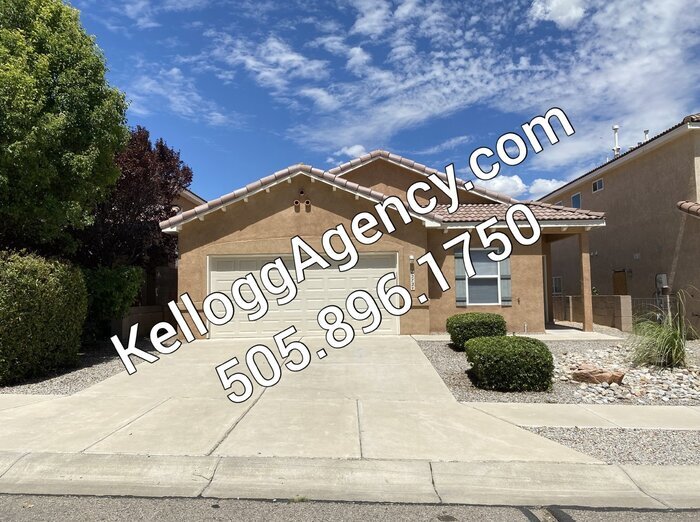
$1,995 / Month

6272 Sierra Nevada Cir NW

,

Albuquerque, NM 87114

Share Listing
Favorites
6272 Sierra Nevada Cir NW
Share Listing
Favorites

Check Back Soon for Upcoming Availability

Beds Baths Average SF
4 Bedrooms 4 Bedrooms 4 Br 2 Baths 2 Baths 2 Ba 1,809 SF

Fees and Policies

The fees listed below are community-provided and may exclude utilities or add-ons. All payments are made directly to the property and are non-refundable unless otherwise specified.

  • Dogs Allowed
  • Fees not specified
  • Cats Allowed
  • Fees not specified

About This Property

4 BEDROOM, SINGLE STORY, 2 LIVING AREAS. FRESH PAINT THROUGHOUT, Front living room/dining area, family room open to spacious kitchen with great counter/cabinet space, breakfast bar and large pantry. Kitchen appliances included are gas stove, dishwasher and disposal. Family room has gas log fireplace and ceiling fan. This home offers vaulted ceilings, ceiling fans, carpet/tile flooring, window blinds, full hall bathroom, laundry room with washer hook-up and electric or gas dryer hook-ups. Master bedroom w/walk-in closet, double vanity, walk-in shower, garden tub. 2 Car garage w/remotes, alarm available at tenant expense. Refrigerated A/C. Backyard fully fenced and has patio slab. City playground directly across the street and near Seville City Park. Centrally located on the westside of Albuquerque in the Seville Subdivision. Easy commute to ABQ and Rio Rancho. DIRECTIONS: Unser/Irving West > R Kayenta > L Sierra Nevada > R to property. This property allows self guided viewing without an appointment. Contact for details.

6272 Sierra Nevada Cir Nw is a house located in Bernalillo County and the 87114 ZIP Code. This area is served by the Albuquerque Public Schools attendance zone.

Location
6272 Sierra Nevada Cir NW, Albuquerque,
NM 87114
Get Directions
| Edit

Under 30 minutes

Commute Time is calculated at rush hour.
Neighborhood

Paradise Hills Civic is a neighborhood north of Albuquerque consisting of residential neighborhoods, commercial spots, and relaxing green spaces. The center of town is made up of single-family homes while restaurants and shops can be found along Coors Boulevard Northwest, the neighborhood’s eastern border. More eateries can be found by driving 15 miles south into the heart of Albuquerque, and additional shopping can be found north of the neighborhood at places like Cottonwood Mall. Outdoor enthusiasts can appreciate the trails along the Rio Grande, located east of the neighborhood. Renters will find that Paradise Hills Civic’s rental market consist of rentals ranging from luxury apartments to more affordable developments.

Learn more about living in Paradise Hills Civic 

Below are rent ranges for similar nearby apartments

Education
Colleges & Universities Distance
Drive: 3 min 1.2 mi
Drive: 17 min 9.1 mi
Drive: 18 min 9.6 mi
Drive: 20 min 11.7 mi
6272 Sierra Nevada Cir NW is within 3 minutes or 1.2 miles from Central NM C.C., Westside. It is also near Central NM C.C., Adv Tech Ctr and Central NM C.C., WTC.
Schools
Public Elementary School
Grades PK-5
471 Students
Nearby
Public Elementary School
Grades K-5
308 Students
Attendance Zone
Public Elementary School
Grades K-5
482 Students
Attendance Zone
Public Middle School
Grades 6-8
1,035 Students
Attendance Zone
Public High School
Grades 9-12
237 Students
Attendance Zone
Public High School
Grades 9-12
1,762 Students
Attendance Zone
Private Elementary, Middle & High School
Grades K-12
184 Students
Nearby
Private Elementary, Middle & High School
Grades K-12
98 Students
Nearby
Transportation

6272 Sierra Nevada Cir NW is near Albuquerque International Sunport, located 22.7 miles or 44 minutes away.

Commuter Rail Distance
Drive: 15 min 7.2 mi
Sandia Pueblo Rail Runner Station
Drive: 18 min 9.6 mi
Drive: 19 min 9.8 mi
Drive: 25 min 13.6 mi
Drive: 27 min 18.6 mi
Airports Distance
Airports Distance
Albuquerque International Sunport
Drive: 44 min 22.7 mi

Walkability Near 6272 Sierra Nevada Cir NW Albuquerque, NM 87114

Getting Around
Somewhat Walkable
Walkability
30 / 100
Minimal Public Transit
Transit
0 / 100
Very Drivable
Drivability
80 / 100
Fairly Bikeable
Bikeability
40 / 100

Scores provided by

What do Walkability, Transit, Drivability, and Bikeability mean? Walkability measures the walking distance to day-to-day needs. Transit measures access to public transportation. Drivability measures congestion, parking availability, and access to major roads. Bikeability measures the suitability for cycling. How It Works
-
Soundscore
- / 100

Traffic

-

Airport

-

Businesses

-

Scores provided by

HowLoud What is a Sound Score Rating? A Sound Score Rating aggregates noise caused by vehicle traffic, airplane traffic and local sources. How It Works
Points of Interest

Time and distance from 6272 Sierra Nevada Cir NW.

Shopping Centers Distance
Drive: 3 min 1.4 mi
Drive: 4 min 2.0 mi
Drive: 5 min 2.1 mi
6272 Sierra Nevada Cir NW has 3 shopping centers within 2.1 miles, which is about a 5-minute drive. The miles and minutes will be for the farthest away property.
Parks and Recreation Distance
Piedras Marcadas Canyon
Drive: 7 min 2.9 mi
Open Space Visitor Center
Drive: 12 min 4.9 mi
Boca Negra Canyon
Drive: 10 min 5.4 mi
Petroglyph National Monument
Drive: 13 min 6.4 mi
Rio Grande Community Farm
Drive: 16 min 8.1 mi
6272 Sierra Nevada Cir NW has 5 parks within 8.1 miles, including Piedras Marcadas Canyon, Open Space Visitor Center, and Boca Negra Canyon.
Hospitals Distance
Hospitals Distance
Drive: 8 min 4.0 mi
Drive: 16 min 9.6 mi
Drive: 22 min 12.2 mi
6272 Sierra Nevada Cir NW has 3 hospitals within 12.2 miles, the nearest is Lovelace Westside Hospital which is 4.0 miles away and a 8 minute drive.
Military Bases Distance
Drive: 52 min 24.4 mi
6272 Sierra Nevada Cir NW is 24.4 miles and a 52 minute drive from Kirtland Air Force Base.

You May Also Like

Similar Rentals Nearby