
Presidential Towers
555 W Madison St,
Chicago, IL 60661
$1,663 - $6,709
Studio - 2 Beds


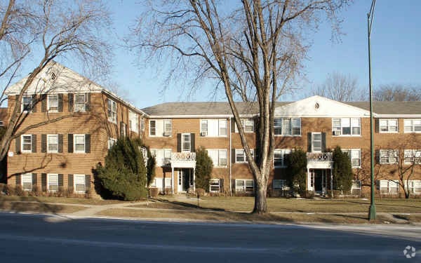
Meet your new apartment at 6233-6265 N. Cicero Avenue in Chicago, IL. These apartments are located on N. Cicero Ave in Chicago. From availability to location, the professional leasing staff will assist you in finding the perfect place to live. Come by to check out the apartment floorplan options. Drop by the leasing office to check current floorplan availability.
6233-6265 N. Cicero Avenue is an apartment community located in Cook County and the 60646 ZIP Code. This area is served by the Chicago Public Schools attendance zone.
Air Conditioning
High Speed Internet Access
Refrigerator
Tub/Shower
Located about 12 miles northwest of Chicago’s Loop, Sauganash offers residents a suburban atmosphere without having to leave the city. A wide variety of homes are available for rent in Sauganash, from red-brick townhomes to stately houses and everything in between. The engaging Sauganash Community Association hosts fun annual events for residents throughout the year, such as the 4th of July Parade and the Bob Perkaus Memorial 5K, fostering a strong sense of community in the neighborhood.
Sauganash’s lush greenery is part of its appeal, with plenty of tree-lined streets and scenic parks like Sauganash Park, LaBagh Woods, Forest Glen Woods, and North Park Village Nature Center nearby. While Sauganash is predominantly residential, the neighborhood is just a short distance from Chicago’s many metropolitan amenities. Convenience to multiple train stations, CTA buses, and I-94 makes getting around from Sauganash simple.
Learn more about living in SauganashCompare neighborhood and city base rent averages by bedroom.
| Sauganash | Chicago, IL | |
|---|---|---|
| Studio | $776 | $1,654 |
| 1 Bedroom | $1,030 | $2,056 |
| 2 Bedrooms | $1,237 | $2,594 |
| 3 Bedrooms | $2,271 | $3,107 |
| Colleges & Universities | Distance | ||
|---|---|---|---|
| Colleges & Universities | Distance | ||
| Drive: | 5 min | 2.1 mi | |
| Drive: | 7 min | 2.8 mi | |
| Drive: | 7 min | 3.5 mi | |
| Drive: | 10 min | 4.8 mi |


Transportation options available in Chicago include Oakton-Skokie, located 2.5 miles from 6233-6265 N. Cicero Avenue. 6233-6265 N. Cicero Avenue is near Chicago O'Hare International, located 9.7 miles or 18 minutes away, and Chicago Midway International, located 16.6 miles or 29 minutes away.
| Transit / Subway | Distance | ||
|---|---|---|---|
| Transit / Subway | Distance | ||
|
|
Drive: | 6 min | 2.5 mi |
|
|
Drive: | 5 min | 2.6 mi |
|
|
Drive: | 7 min | 3.5 mi |
|
|
Drive: | 7 min | 3.9 mi |
|
|
Drive: | 7 min | 4.5 mi |
| Commuter Rail | Distance | ||
|---|---|---|---|
| Commuter Rail | Distance | ||
|
|
Drive: | 3 min | 1.4 mi |
|
|
Drive: | 4 min | 1.8 mi |
|
|
Drive: | 5 min | 2.5 mi |
|
|
Drive: | 7 min | 3.5 mi |
|
|
Drive: | 7 min | 3.7 mi |
| Airports | Distance | ||
|---|---|---|---|
| Airports | Distance | ||
|
Chicago O'Hare International
|
Drive: | 18 min | 9.7 mi |
|
Chicago Midway International
|
Drive: | 29 min | 16.6 mi |
Scores provided by
Traffic
-Airport
-Businesses
-Scores provided by
HowLoud What is a Sound Score Rating? A Sound Score Rating aggregates noise caused by vehicle traffic, airplane traffic and local sources. How It WorksTime and distance from 6233-6265 N. Cicero Avenue.
| Shopping Centers | Distance | ||
|---|---|---|---|
| Shopping Centers | Distance | ||
| Walk: | 5 min | 0.3 mi | |
| Walk: | 18 min | 0.9 mi | |
| Drive: | 4 min | 1.5 mi |
| Parks and Recreation | Distance | ||
|---|---|---|---|
| Parks and Recreation | Distance | ||
|
Indian Road Woods
|
Walk: | 30 min | 1.6 mi |
|
North Park Village Nature Center
|
Drive: | 3 min | 1.6 mi |
|
Labagh Woods
|
Drive: | 5 min | 1.6 mi |
|
Gompers Park
|
Drive: | 5 min | 2.1 mi |
|
Laramie Park
|
Drive: | 5 min | 2.1 mi |
| Hospitals | Distance | ||
|---|---|---|---|
| Hospitals | Distance | ||
| Drive: | 7 min | 3.6 mi | |
| Drive: | 9 min | 4.5 mi | |
| Drive: | 9 min | 4.7 mi |
| Military Bases | Distance | ||
|---|---|---|---|
| Military Bases | Distance | ||
| Drive: | 27 min | 17.3 mi | |
| Drive: | 35 min | 26.1 mi | |
| Drive: | 48 min | 31.4 mi |
What Are Walk Score®, Transit Score®, and Bike Score® Ratings?
Walk Score® measures the walkability of any address. Transit Score® measures access to public transit. Bike Score® measures the bikeability of any address.
What is a Sound Score Rating?
A Sound Score Rating aggregates noise caused by vehicle traffic, airplane traffic and local sources.
6233-6265 N Cicero Ave
Chicago, IL 60646


