
Presidential Towers
555 W Madison St,
Chicago, IL 60661
$1,670 - $6,580
Studio - 2 Beds
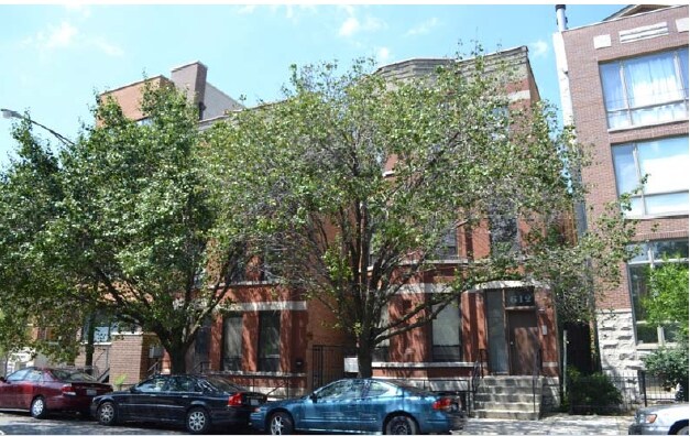

Find your new apartment at 610 N May St in Chicago, IL. This community is located in the West Town area of Chicago. From amenities to availability, the professional leasing team is available to help you find your perfect home. Leasing 2 to 3 bedroom apartments, your new home is right here. Your new home awaits you at 610 N May St. Contact us or stop by the leasing office to learn more about our community.
610 N May St is an apartment community located in Cook County and the 60642 ZIP Code. This area is served by the Chicago Public Schools attendance zone.
West Town is an eclectic section of Chicago known for its hip aesthetic. Taprooms, breweries, vintage shops, galleries, and public art line the streets. West Town is largely influenced by diverse cultures. Residents will find restaurants serving almost every type of cuisine concentrated along Chicago Avenue. This street holds long-standing buildings housing some of Chicago’s best food and drinks. After a day of shopping and dining, catch a show at the Empty Bottle, explore the Intuit: the Center for Intuitive and Outsider Art, or visit Humboldt Park, an expansive park featuring trails, a lake, and gorgeous scenery a bit north of the neighborhood. Renters who live in this quirky section of Chicago have an abundance of choices. Renovated, long-standing places to modern developments make up the rental scene in West Town.
Learn more about living in West TownCompare neighborhood and city base rent averages by bedroom.
| West Town | Chicago, IL | |
|---|---|---|
| Studio | $1,598 | $1,656 |
| 1 Bedroom | $1,849 | $2,057 |
| 2 Bedrooms | $2,854 | $2,599 |
| 3 Bedrooms | $5,902 | $3,114 |
| Colleges & Universities | Distance | ||
|---|---|---|---|
| Colleges & Universities | Distance | ||
| Walk: | 16 min | 0.9 mi | |
| Drive: | 3 min | 1.4 mi | |
| Drive: | 3 min | 1.4 mi | |
| Drive: | 4 min | 1.5 mi |


Transportation options available in Chicago include Chicago Avenue Station (Blue Line), located 0.3 mile from 610 N May St. 610 N May St is near Chicago Midway International, located 10.2 miles or 18 minutes away, and Chicago O'Hare International, located 16.1 miles or 24 minutes away.
| Transit / Subway | Distance | ||
|---|---|---|---|
| Transit / Subway | Distance | ||
|
|
Walk: | 5 min | 0.3 mi |
|
|
Walk: | 10 min | 0.5 mi |
|
|
Walk: | 12 min | 0.7 mi |
|
|
Walk: | 17 min | 0.9 mi |
|
|
Drive: | 2 min | 1.1 mi |
| Commuter Rail | Distance | ||
|---|---|---|---|
| Commuter Rail | Distance | ||
|
|
Drive: | 3 min | 1.3 mi |
|
|
Drive: | 4 min | 1.7 mi |
|
|
Drive: | 4 min | 1.9 mi |
|
|
Drive: | 3 min | 2.1 mi |
|
|
Drive: | 6 min | 2.3 mi |
| Airports | Distance | ||
|---|---|---|---|
| Airports | Distance | ||
|
Chicago Midway International
|
Drive: | 18 min | 10.2 mi |
|
Chicago O'Hare International
|
Drive: | 24 min | 16.1 mi |
Scores provided by
Traffic
-Airport
-Businesses
-Scores provided by
HowLoud What is a Sound Score Rating? A Sound Score Rating aggregates noise caused by vehicle traffic, airplane traffic and local sources. How It WorksTime and distance from 610 N May St.
| Shopping Centers | Distance | ||
|---|---|---|---|
| Shopping Centers | Distance | ||
| Walk: | 15 min | 0.8 mi | |
| Drive: | 2 min | 1.3 mi |
| Parks and Recreation | Distance | ||
|---|---|---|---|
| Parks and Recreation | Distance | ||
|
Alliance for the Great Lakes
|
Drive: | 5 min | 2.1 mi |
|
Openlands
|
Drive: | 5 min | 2.1 mi |
|
Lake Shore Park
|
Drive: | 5 min | 2.2 mi |
|
Millennium Park
|
Drive: | 5 min | 2.2 mi |
|
Oz Park
|
Drive: | 5 min | 2.9 mi |
| Hospitals | Distance | ||
|---|---|---|---|
| Hospitals | Distance | ||
| Drive: | 4 min | 1.6 mi | |
| Drive: | 3 min | 1.7 mi | |
| Drive: | 4 min | 1.9 mi |
| Military Bases | Distance | ||
|---|---|---|---|
| Military Bases | Distance | ||
| Drive: | 32 min | 23.7 mi | |
| Drive: | 42 min | 28.9 mi | |
| Drive: | 53 min | 33.9 mi |
What Are Walk Score®, Transit Score®, and Bike Score® Ratings?
Walk Score® measures the walkability of any address. Transit Score® measures access to public transit. Bike Score® measures the bikeability of any address.
What is a Sound Score Rating?
A Sound Score Rating aggregates noise caused by vehicle traffic, airplane traffic and local sources.

610 N May St
Chicago, IL 60642


