

$1,495
Total Monthly Price
61 Laurel Ln
Bellingham, MA 02019
2 Weeks Ago
|
Edit
Favorites
61 Laurel Ln

Favorites
Check Back Soon for Upcoming Availability
| Beds | Baths | Average SF |
|---|---|---|
| 3 Bedrooms 3 Bedrooms 3 Br | 1 Bath 1 Bath 1 Ba | — |
About This Property
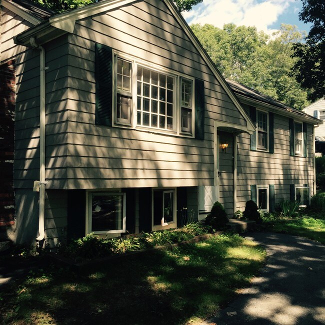
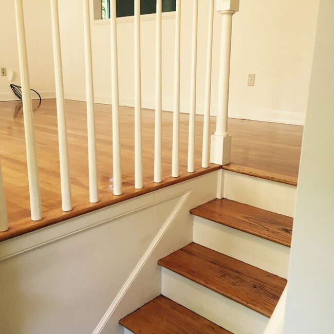
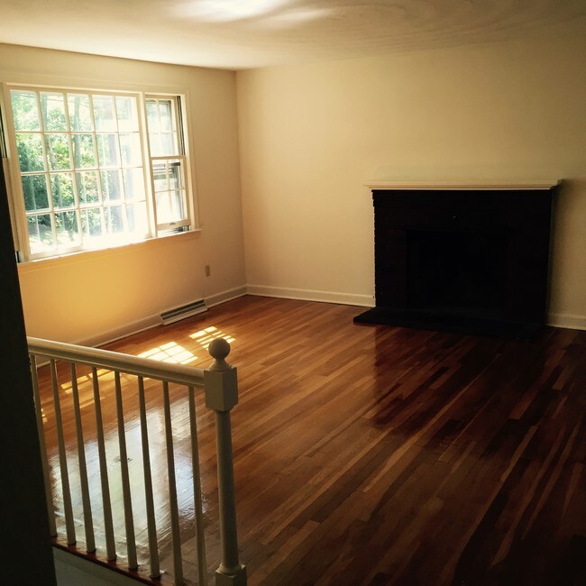
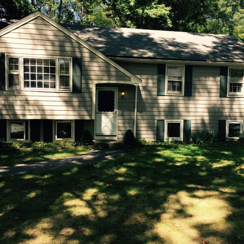
This lovely home features 7 large rooms including 3 Large Bedrooms, Living Room with ornamental fireplace, eat-in Kitchen with stove and dishwasher/Dining Room, full Bath, and lower level Family Room/Office. You will love relaxing on the attached deck in the privacy of your own back yard! Laundry hook-ups in basement. Hardwood Floors. Forced Hot Air Oil Heat. Awesome commuter location - close to Boston, Providence and Worcester. Tenant pays all utilities except for water, sewer, and rubbish pick-up. Non Smoking No Pets Come to the Open House to view (no appointment needed nor taken): Sat, April 13 @ 2pm - 2:30pm Sun., April 14 @ 2pm - 2:30pm Monday, April 15 @ 6:00 - 6:30pm 61 Laurel Lane, Bellingham, MA 02019 Single Family Home
61 Laurel Ln is a house located in Norfolk County and the 02019 ZIP Code. This area is served by the Bellingham School District attendance zone.
61 Laurel Ln,
Bellingham,
MA
02019
495-South is a large area surrounding Interstate 495 about 20 miles south of Boston. This suburban town features peaceful neighborhoods nestled in forested areas paired with commercial developments. Renters have the choice of moderately priced to luxury apartments, condos, and single-family homes. An abundance of shopping and dining choices are scattered along the town’s major thoroughfares. Ponds, creeks, and large natural areas like Franklin State Forest and DelCarte Conservation Area provide relaxing outdoor activities. Residents have access to big-city amenities by driving a bit north into Boston, and the eclectic downtown districts of Worcester and Framingham are situated outside of the western and eastern corners of town.
Learn more about living in 495-SouthBelow are rent ranges for similar nearby apartments
Education
| Colleges & Universities | Distance | ||
|---|---|---|---|
| Colleges & Universities | Distance | ||
| Drive: | 21 min | 12.0 mi | |
| Drive: | 20 min | 12.6 mi | |
| Drive: | 24 min | 16.8 mi | |
| Drive: | 26 min | 17.4 mi |
61 Laurel Ln is within 20 minutes or 12.6 miles from Bryant University. It is also near C.C. of Rhode Island, Flanagan and Providence College.
Schools


Public Elementary School
Grades PK-2
480 Students
Nearby
Public Elementary School
Grades 3-5
427 Students
Nearby
Public Elementary School
Grades K-5
383 Students
Attendance Zone
Public Middle School
Grades 6-8
444 Students
Nearby
Public Middle & High School
Grades 6-12
764 Students
Attendance Zone
Public Middle & High School
Grades 6-12
26 Students
Attendance Zone
Private Elementary, Middle & High School
Grades K-12
17 Students
Nearby
Private Elementary & Middle School
Grades PK-8
226 Students
Nearby
Private Elementary School
Grades K-5
Nearby
Private Middle & High School
Grades 6-12
570 Students
Nearby
School data provided by
 The GreatSchools Rating helps parents compare schools within a state based on a variety of school quality indicators and provides a helpful picture of how effectively each school serves all of its students. Ratings are on a scale of 1 (below average) to 10 (above average) and can include test scores, college readiness, academic progress, advanced courses, equity, discipline and attendance data. We also advise parents to visit schools, consider other information on school performance and programs, and consider family needs as part of the school selection process.
View GreatSchools Rating Methodology
Data provided by GreatSchools.org © 2026. All rights reserved.
View GreatSchools Rating Methodology
Data provided by GreatSchools.org © 2026. All rights reserved.
Walkability Near 61 Laurel Ln Bellingham, MA 02019
Getting Around
 What do Walkability, Transit, Drivability, and Bikeability mean?
Walkability measures the walking distance to day-to-day needs.
Transit measures access to public transportation.
Drivability measures congestion, parking availability, and access to major roads.
Bikeability measures the suitability for cycling.
How It Works
What do Walkability, Transit, Drivability, and Bikeability mean?
Walkability measures the walking distance to day-to-day needs.
Transit measures access to public transportation.
Drivability measures congestion, parking availability, and access to major roads.
Bikeability measures the suitability for cycling.
How It Works
Somewhat Walkable
Walkability
30
/ 100
Minimal Public Transit
Transit
0
/ 100
Exceptionally Drivable
Drivability
90
/ 100
Somewhat Bikeable
Bikeability
30
/ 100
Scores provided by
-
Soundscore™
-
/ 100
Traffic
-Airport
-Businesses
-Scores provided by
HowLoud What is a Sound Score Rating? A Sound Score Rating aggregates noise caused by vehicle traffic, airplane traffic and local sources. How It WorksYou May Also Like
Similar Rentals Nearby
-
-

-

-

-

-

-

-

-

-
 3 Beds, 1 Bath, 1,200 sq ft$2,300Total Monthly Price12 Month LeaseTotal Monthly Price NewPrices include all required monthly fees.60 Concord St
What Are Walk Score®, Transit Score®, and Bike Score® Ratings?
Walk Score® measures the walkability of any address. Transit Score® measures access to public transit. Bike Score® measures the bikeability of any address.
What is a Sound Score Rating?
A Sound Score Rating aggregates noise caused by vehicle traffic, airplane traffic and local sources.
61 Laurel Ln
Bellingham, MA 02019