
$2,500
/ Month
6090 Saturn St
Los Angeles, CA 90035
Today
Favorites
310-818-6554
-
Bedrooms
1
-
Bathrooms
1
-
Square Feet
650 sq ft
-
Available
Available Now
Highlights
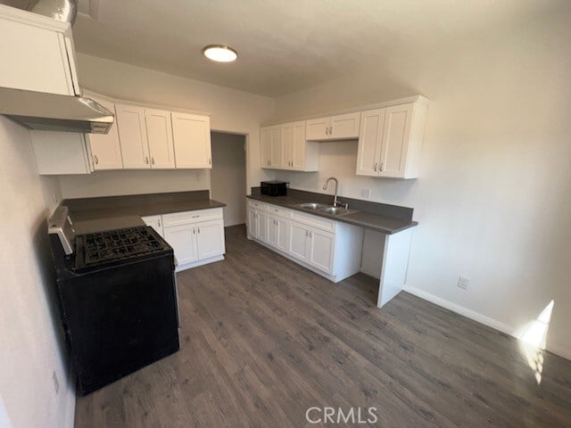
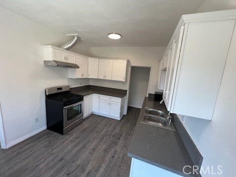
- Granite Countertops
- Eat-In Kitchen
- Double Pane Windows
- Cooling System Mounted To A Wall/Window
- Patio
- Laundry Room
6090 Saturn St

Favorites
About This Home
12 Month Lease,
$2,500 deposit,
Available Now
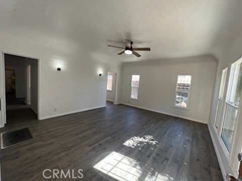
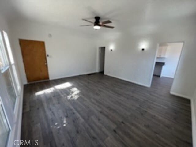
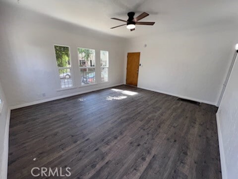
Newly renovated apartment. It has Air conditioning, vinyl flooring, stainless steel appliances, stove , microwave, dishwasher, refrigerator, high ceilings. #2 is the lower unit. No pets. Street parking only. Water & Trash paid. One year lease. Minimum of 700 credit score is required, income has to be 2.5 X times the rent. MLS# IG25184144
6090 Saturn St is a townhome located in Los Angeles County and the 90035 ZIP Code. This area is served by the Los Angeles Unified attendance zone.
* Price shown is base rent and may not include non-optional fees and utilities. Price, availability, fees, and any applicable rent special are subject to change without notice.
* Square footage definitions vary. Displayed square footage is approximate.
Home Details
Year Built
Built in 2023
Accessible Home Design
Entry on the 1st floor
Bedrooms and Bathrooms
1 Main Level Bedroom
1 Full Bathroom
Home Design
Quadruplex
Interior Spaces
Double Pane Windows
650 Sq Ft Home
2-Story Property
Kitchen
Granite Countertops
Eat-In Kitchen
Laundry
Laundry Room
Listing and Financial Details
Security Deposit $2,500
12-Month Minimum Lease Term
Available 8/14/25
Rent includes trash collection, water
Location
Urban Location
Lot Details
0.34 Acre Lot
1 Common Wall
Density is up to 1 Unit/Acre
Outdoor Features
Patio
Parking
On-Street Parking
Utilities
Cooling System Mounted To A Wall/Window
Wall Furnace
Community Details
Overview
2 Units
No Home Owners Association
Pet Policy
Pet Deposit $500
Fees and Policies
The fees below are based on community-supplied data and may exclude additional fees and utilities.
- Parking
-
Street--
Details
Utilities Included
-
Water
-
Trash Removal
Lease Options
-
12 Months
Contact
- Listed by Dora Szugyi | HARTNELL REAL ESTATE
- Phone Number
- Contact
-
Source
 California Regional Multiple Listing Service
Copyright 2025 © California Regional MLS. All rights reserved.
Location
Get Directions
Amenities
- Air Conditioning
- Heating
- Double Pane Windows
- Patio
Expenses
Utilities Included
Water, Trash Removal
Included
Located just a couple of minutes west of downtown LA, Mid-Wilshire is one of the city’s most popular areas for art, food, and shopping. The wild architecture of the Petersen Museum is the most distinctive landmark, and other must-see attractions include the Los Angeles County Museum of Art, the Pavilion for Japanese Art, and the La Brea Tar Pits and Museum, which are all within one block of one another.
The famous Miracle Mile shopping district anchors the community, with numerous office buildings, eclectic eateries, convenient shops, and the historic El Rey Theatre. Foodies swear by the cafes of Little Ethiopia, and the gastronomic wonderland of Koreatown is just a few blocks away.
Much of the neighborhood is residential, incorporating everything from suburban single-family homes with manicured lawns to ultra-modern apartments and condos in the thick of it all.
Learn more about living in Beverly Grove
Education
| Colleges & Universities | Distance | ||
|---|---|---|---|
| Colleges & Universities | Distance | ||
| Drive: | 11 min | 4.5 mi | |
| Drive: | 11 min | 5.5 mi | |
| Drive: | 12 min | 5.9 mi | |
| Drive: | 13 min | 7.6 mi |
6090 Saturn St is within 11 minutes or 4.5 miles from West Los Angeles College. It is also near Musicians Institute and UCLA.
Schools


Public Elementary School
Grades K-5
542 Students
Nearby
Public Middle School
Grades 6-8
442 Students
Attendance Zone
Public High School
Grades 9-12
2,259 Students
Attendance Zone
Private Elementary & Middle School
Grades K-8
357 Students
Nearby
Private Elementary & Middle School
Grades K-8
312 Students
Nearby
Private High School
Grades 9-12
Nearby
School data provided by
 The GreatSchools Rating helps parents compare schools within a state based on a variety of school quality indicators and provides a helpful picture of how effectively each school serves all of its students. Ratings are on a scale of 1 (below average) to 10 (above average) and can include test scores, college readiness, academic progress, advanced courses, equity, discipline and attendance data. We also advise parents to visit schools, consider other information on school performance and programs, and consider family needs as part of the school selection process.
View GreatSchools Rating Methodology
Data provided by GreatSchools.org © 2025. All rights reserved.
View GreatSchools Rating Methodology
Data provided by GreatSchools.org © 2025. All rights reserved.
Transportation options available in Los Angeles include La Cienega/Jefferson, located 2.1 miles from 6090 Saturn St. 6090 Saturn St is near Los Angeles International, located 9.1 miles or 18 minutes away, and Bob Hope, located 13.8 miles or 26 minutes away.
| Transit / Subway | Distance | ||
|---|---|---|---|
| Transit / Subway | Distance | ||
|
|
Drive: | 5 min | 2.1 mi |
|
|
Drive: | 5 min | 2.1 mi |
|
|
Drive: | 5 min | 2.9 mi |
|
|
Drive: | 7 min | 3.3 mi |
|
|
Drive: | 8 min | 3.6 mi |
| Commuter Rail | Distance | ||
|---|---|---|---|
| Commuter Rail | Distance | ||
|
|
Drive: | 17 min | 10.3 mi |
|
|
Drive: | 19 min | 10.4 mi |
|
|
Drive: | 20 min | 11.5 mi |
|
|
Drive: | 23 min | 11.8 mi |
|
|
Drive: | 25 min | 12.7 mi |
| Airports | Distance | ||
|---|---|---|---|
| Airports | Distance | ||
|
Los Angeles International
|
Drive: | 18 min | 9.1 mi |
|
Bob Hope
|
Drive: | 26 min | 13.8 mi |
Time and distance from 6090 Saturn St.
| Shopping Centers | Distance | ||
|---|---|---|---|
| Shopping Centers | Distance | ||
| Walk: | 4 min | 0.2 mi | |
| Walk: | 13 min | 0.7 mi | |
| Walk: | 13 min | 0.7 mi |
6090 Saturn St has 3 shopping centers within 0.7 mile, which is about a 13-minute walk. The miles and minutes will be for the farthest away property.
| Parks and Recreation | Distance | ||
|---|---|---|---|
| Parks and Recreation | Distance | ||
|
Zimmer Children's Museum
|
Drive: | 3 min | 1.4 mi |
|
La Brea Tar Pits
|
Drive: | 4 min | 1.8 mi |
|
Kenneth Hahn State Recreation Area
|
Drive: | 11 min | 4.2 mi |
|
Virginia Robinson Gardens
|
Drive: | 10 min | 4.2 mi |
|
Mathias Botanical Garden
|
Drive: | 12 min | 5.4 mi |
6090 Saturn St has 5 parks within 5.4 miles, including Zimmer Children's Museum, La Brea Tar Pits, and Kenneth Hahn State Recreation Area.
| Hospitals | Distance | ||
|---|---|---|---|
| Hospitals | Distance | ||
| Walk: | 20 min | 1.1 mi | |
| Drive: | 2 min | 1.1 mi | |
| Drive: | 2 min | 1.2 mi |
6090 Saturn St has 3 hospitals within 1.2 miles, the nearest is Docs Surgical Hospital which is 1.1 miles away and a 20 minute walk.
| Military Bases | Distance | ||
|---|---|---|---|
| Military Bases | Distance | ||
| Drive: | 18 min | 10.7 mi |
6090 Saturn St is 10.7 miles and a 18 minute drive from Los Angeles Air Force Base.
You May Also Like
Similar Rentals Nearby


What Are Walk Score®, Transit Score®, and Bike Score® Ratings?
Walk Score® measures the walkability of any address. Transit Score® measures access to public transit. Bike Score® measures the bikeability of any address.
What is a Sound Score Rating?
A Sound Score Rating aggregates noise caused by vehicle traffic, airplane traffic and local sources
6090 Saturn St
Los Angeles, CA 90035