
$3,300
/ Month
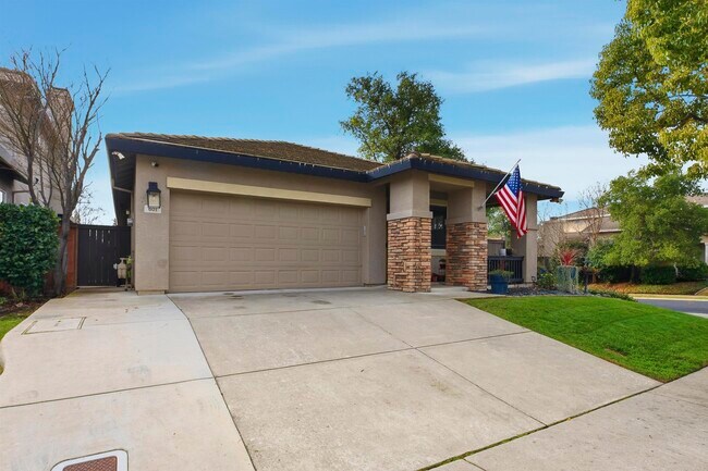
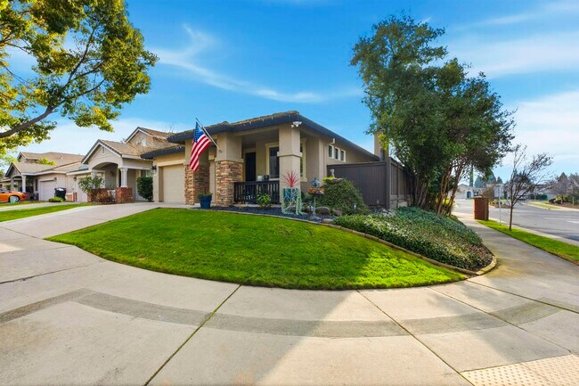
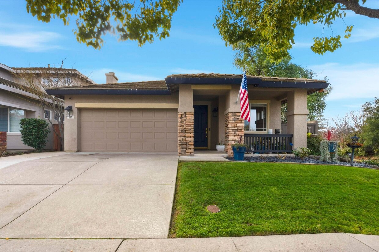
601 Tamarindo Way
Roseville, CA 95678
Today
|
Edit
Favorites
925-580-0323
-
Bedrooms
4
-
Bathrooms
2
-
Square Feet
1,677 sq ft
-
Available
Available Jan 24
601 Tamarindo Way

Favorites
About This Home
Available Jan 24
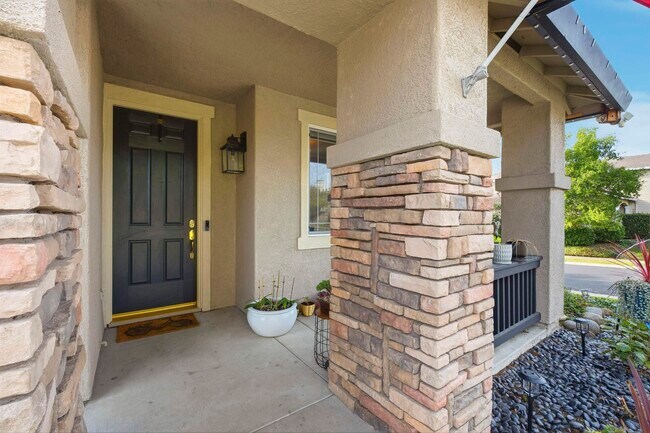
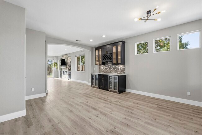
Available 03/01 – Fantastic Highland Reserve Opportunity! Charming,updated 4-bedroom,2-bath home (one bedroom currently used as an office) on a prime corner lot in Roseville with no rear or side neighbors. Super convenient location near schools,parks,and trails,shopping and restaurants,plus easy freeway access. Features include a remodeled kitchen/family room combo with quartzite countertops and stainless steel appliances,a formal living room,updated bathrooms,fresh interior/exterior paint,Nest thermostat,security system,and ample storage in 2-car garage and attic. Enjoy outdoor living with a custom propane fire pit,automatic sprinklers,and LumenX permanent lighting for year-round holiday displays. Gardener included. Pets welcome with approval and an additional rent/deposit. One-year lease or longer preferred. Apply with RentSpree
601 Tamarindo Way is a house located in Placer County and the 95678 ZIP Code. This area is served by the Roseville City Elementary attendance zone.
* Price shown is base rent. Excludes user-selected optional fees and variable or usage-based fees and required charges due at or prior to move-in or at move-out. Price, availability, fees, and any applicable rent special are subject to change without notice.
* Square footage definitions vary. Displayed square footage is approximate.
Contact
- Listed by Staci Tate | Golden Gate Sotheby's Int'l
- Phone Number
- Contact
-
Source
 Bay East Association of REALTORS ®
Copyright© 2026 Bay East, Contra Costa, bridgeMLS. All rights reserved. All information provided by the listing agent/broker is deemed reliable but is not guaranteed and should be independently verified.
Location
Get Directions
Located in the Sacramento Valley, Roseville combines residential comfort with city conveniences. The city offers diverse housing options throughout its neighborhoods, from newer developments near Westfield Galleria to historic properties in Old Town. Current rental trends show steady market conditions, with one-bedroom apartments averaging $1,921 per month, while larger three-bedroom units typically rent for $2,780. The city's rental market has remained relatively stable, with modest year-over-year increases ranging from 0.9% to 2.3% across different unit sizes.
What began as a railroad town has evolved into a shopping and entertainment hub that maintains its small-town atmosphere. The Fountains at Roseville and Westfield Galleria provide extensive retail options, while Maidu Regional Park and Royer Park offer recreational spaces. Major employers like Kaiser Permanente and Hewlett Packard Enterprise contribute to local employment opportunities.
Learn more about living in Roseville
Education
| Colleges & Universities | Distance | ||
|---|---|---|---|
| Colleges & Universities | Distance | ||
| Drive: | 10 min | 5.8 mi | |
| Drive: | 21 min | 13.6 mi | |
| Drive: | 30 min | 16.1 mi | |
| Drive: | 31 min | 21.9 mi |
601 Tamarindo Way is within 10 minutes or 5.8 miles from Sierra College, Rocklin Campus. It is also near American River College and Folsom Lake College, Folsom.
Schools


Public Elementary School
Grades K-5
392 Students
Attendance Zone
Public Elementary School
Grades K-3
372 Students
Nearby
Public Middle School
Grades 6-8
860 Students
Attendance Zone
Public High School
Grades 9-12
1,617 Students
Attendance Zone
Private Elementary School
Grades K-6
27 Students
Nearby
Private Elementary School
Grades PK-K
Nearby
Private Elementary & Middle School
Grades PK-8
761 Students
Nearby
Private Elementary, Middle & High School
Grades 1-12
Nearby
School data provided by
 The GreatSchools Rating helps parents compare schools within a state based on a variety of school quality indicators and provides a helpful picture of how effectively each school serves all of its students. Ratings are on a scale of 1 (below average) to 10 (above average) and can include test scores, college readiness, academic progress, advanced courses, equity, discipline and attendance data. We also advise parents to visit schools, consider other information on school performance and programs, and consider family needs as part of the school selection process.
View GreatSchools Rating Methodology
Data provided by GreatSchools.org © 2026. All rights reserved.
View GreatSchools Rating Methodology
Data provided by GreatSchools.org © 2026. All rights reserved.
Transportation options available in Roseville include Historic Folsom, located 13.4 miles from 601 Tamarindo Way. 601 Tamarindo Way is near Sacramento International, located 25.2 miles or 38 minutes away.
| Transit / Subway | Distance | ||
|---|---|---|---|
| Transit / Subway | Distance | ||
|
|
Drive: | 22 min | 13.4 mi |
|
|
Drive: | 23 min | 14.3 mi |
| Commuter Rail | Distance | ||
|---|---|---|---|
| Commuter Rail | Distance | ||
|
|
Drive: | 7 min | 3.3 mi |
|
|
Drive: | 9 min | 4.8 mi |
| Drive: | 21 min | 17.2 mi | |
|
|
Drive: | 22 min | 17.2 mi |
| Drive: | 28 min | 22.8 mi |
| Airports | Distance | ||
|---|---|---|---|
| Airports | Distance | ||
|
Sacramento International
|
Drive: | 38 min | 25.2 mi |
Time and distance from 601 Tamarindo Way.
| Shopping Centers | Distance | ||
|---|---|---|---|
| Shopping Centers | Distance | ||
| Walk: | 5 min | 0.3 mi | |
| Walk: | 7 min | 0.4 mi | |
| Walk: | 9 min | 0.5 mi |
601 Tamarindo Way has 3 shopping centers within 0.5 mile, which is about a 9-minute walk. The miles and minutes will be for the farthest away property.
| Parks and Recreation | Distance | ||
|---|---|---|---|
| Parks and Recreation | Distance | ||
|
Mahany Park
|
Drive: | 6 min | 3.0 mi |
|
Mahan Park
|
Drive: | 9 min | 5.2 mi |
|
Luken Park
|
Drive: | 9 min | 5.3 mi |
|
Sierra College Natural History Museum
|
Drive: | 9 min | 5.8 mi |
|
Astill Family Park
|
Drive: | 12 min | 6.8 mi |
601 Tamarindo Way has 5 parks within 6.8 miles, including Mahany Park, Luken Park, and Mahan Park.
| Hospitals | Distance | ||
|---|---|---|---|
| Hospitals | Distance | ||
| Drive: | 6 min | 3.1 mi | |
| Drive: | 7 min | 3.8 mi | |
| Drive: | 18 min | 11.8 mi |
601 Tamarindo Way has 3 hospitals within 11.8 miles, the nearest is Sutter Roseville Medical Center which is 3.1 miles away and a 6 minute drive.
| Military Bases | Distance | ||
|---|---|---|---|
| Military Bases | Distance | ||
| Drive: | 29 min | 16.4 mi |
601 Tamarindo Way is 16.4 miles and a 29 minute drive from McClellan Air Force Base.
You May Also Like
Similar Rentals Nearby


What Are Walk Score®, Transit Score®, and Bike Score® Ratings?
Walk Score® measures the walkability of any address. Transit Score® measures access to public transit. Bike Score® measures the bikeability of any address.
What is a Sound Score Rating?
A Sound Score Rating aggregates noise caused by vehicle traffic, airplane traffic and local sources
601 Tamarindo Way
Roseville, CA 95678