$2,500
/ Month
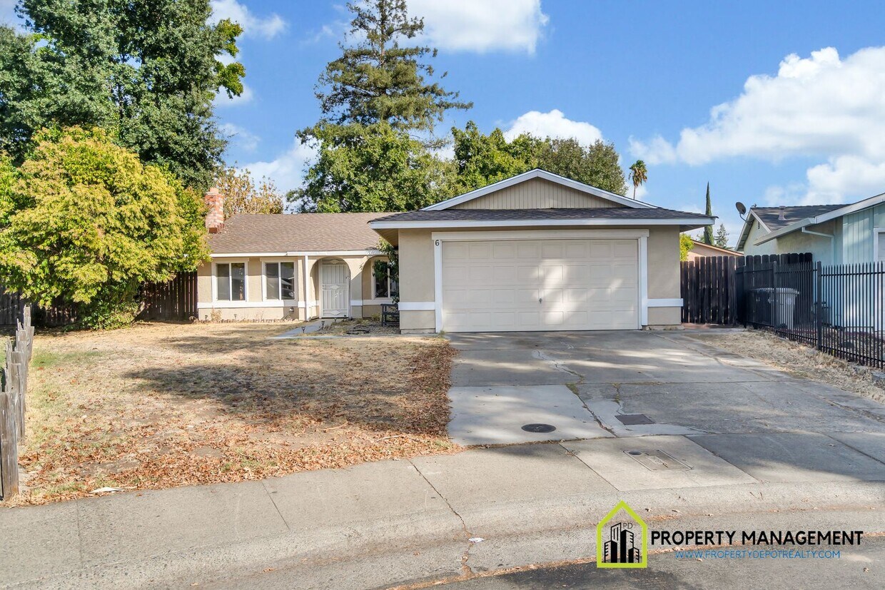
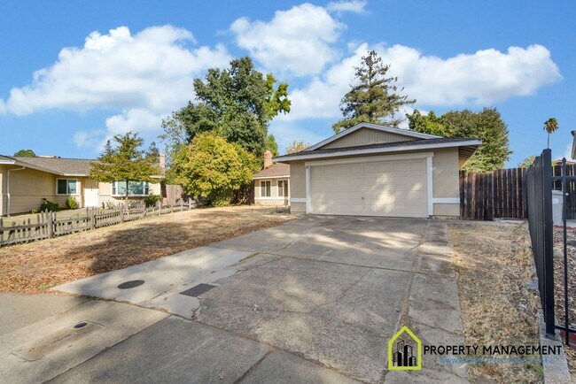
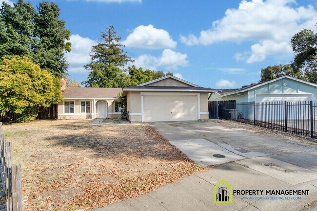
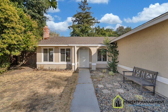
6 Nunes Ct
Sacramento, CA 95823
2 Weeks Ago
|
Edit
Favorites
6 Nunes Ct

Favorites
Check Back Soon for Upcoming Availability
| Beds | Baths | Average SF |
|---|---|---|
| 4 Bedrooms 4 Bedrooms 4 Br | 2 Baths 2 Baths 2 Ba | 1,300 SF |
About This Property
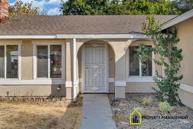
Embrace elegance in this beautifully remodeled 4bedroom, 2bath residence. Enjoy modern updates throughout, including an updated kitchen, fresh paint,and sleek tile flooring. Nestled in a serene court, this home features a spacious backyard perfect for outdoor activities. *Rent: $2500 *Deposit: $2500 *Term: 12 months lease *Utilities: $200 (sewer/water/trash) *Renter's insurance is required. Screening Guidelines: 1. All individuals over the age of 18 planning on living at the property, are required to apply. Application fee is $50 per adult. 2. A credit score of at least 650 required of all applicants. 3. Good rental references. No evictions, no exceptions. 4. A household monthly income of at least 3x the monthly rent amount. 5. Two forms of Identification are required, i.e. Driver's License, Social Security Card, Passport, Phone: Email: Apply Here:
6 Nunes Ct is a house located in Sacramento County and the 95823 ZIP Code. This area is served by the Elk Grove Unified School District attendance zone.
6 Nunes Ct,
Sacramento,
CA
95823
Parkway is a suburban neighborhood about ten miles south of Downtown Sacramento. With access to several good schools, parks, shopping plazas, and restaurants, Parkway provides residents with plenty of amenities. Similar to many California neighborhoods, Parkway has mid-range to upscale rental options but there are some more affordable apartments and houses available for rent. Residents also enjoy access to Interstate 5 and Highway 99, allowing for easier trips to some of the city’s most popular destinations. Sacramento City College, California State University, and William Land Regional Park (a sprawling park with lakes, a zoo, and two amusement parks) are all convenient to Parkway.
Learn more about living in ParkwayBelow are rent ranges for similar nearby apartments
Education
| Colleges & Universities | Distance | ||
|---|---|---|---|
| Colleges & Universities | Distance | ||
| Drive: | 6 min | 2.0 mi | |
| Drive: | 13 min | 6.7 mi | |
| Drive: | 18 min | 8.9 mi | |
| Drive: | 28 min | 19.2 mi |
6 Nunes Ct is within 6 minutes or 2.0 miles from Cosumnes River College. It is also near Sacramento City College and Sacramento State.
Schools


Public Elementary School
Grades K-5
450 Students
Nearby
Public Elementary School
Grades K-5
858 Students
Attendance Zone
Public Middle School
Grades 6-8
909 Students
Attendance Zone
Public High School
Grades 9-12
1,622 Students
Attendance Zone
Private Elementary & Middle School
Grades PK-8
Nearby
Private Elementary, Middle & High School
Grades K-12
Nearby
Private Elementary & Middle School
Grades PK-8
198 Students
Nearby
School data provided by
 The GreatSchools Rating helps parents compare schools within a state based on a variety of school quality indicators and provides a helpful picture of how effectively each school serves all of its students. Ratings are on a scale of 1 (below average) to 10 (above average) and can include test scores, college readiness, academic progress, advanced courses, equity, discipline and attendance data. We also advise parents to visit schools, consider other information on school performance and programs, and consider family needs as part of the school selection process.
View GreatSchools Rating Methodology
Data provided by GreatSchools.org © 2026. All rights reserved.
View GreatSchools Rating Methodology
Data provided by GreatSchools.org © 2026. All rights reserved.
Transportation options available in Sacramento include Franklin Station (Wb), located 1.2 miles from 6 Nunes Ct. 6 Nunes Ct is near Sacramento International, located 23.2 miles or 32 minutes away.
| Transit / Subway | Distance | ||
|---|---|---|---|
| Transit / Subway | Distance | ||
| Drive: | 3 min | 1.2 mi | |
| Drive: | 3 min | 1.2 mi | |
| Drive: | 3 min | 1.7 mi | |
| Drive: | 11 min | 2.1 mi | |
| Drive: | 10 min | 3.6 mi |
| Commuter Rail | Distance | ||
|---|---|---|---|
| Commuter Rail | Distance | ||
| Drive: | 18 min | 11.7 mi | |
| Drive: | 32 min | 24.1 mi | |
|
|
Drive: | 34 min | 26.7 mi |
|
|
Drive: | 37 min | 27.8 mi |
|
|
Drive: | 38 min | 30.0 mi |
| Airports | Distance | ||
|---|---|---|---|
| Airports | Distance | ||
|
Sacramento International
|
Drive: | 32 min | 23.2 mi |
Walkability Near 6 Nunes Ct Sacramento, CA 95823
Getting Around
 What do Walkability, Transit, Drivability, and Bikeability mean?
Walkability measures the walking distance to day-to-day needs.
Transit measures access to public transportation.
Drivability measures congestion, parking availability, and access to major roads.
Bikeability measures the suitability for cycling.
How It Works
What do Walkability, Transit, Drivability, and Bikeability mean?
Walkability measures the walking distance to day-to-day needs.
Transit measures access to public transportation.
Drivability measures congestion, parking availability, and access to major roads.
Bikeability measures the suitability for cycling.
How It Works
Fairly Walkable
Walkability
40
/ 100
Limited Public Transit
Transit
30
/ 100
Exceptionally Drivable
Drivability
90
/ 100
Fairly Bikeable
Bikeability
50
/ 100
Scores provided by
-
Soundscore™
-
/ 100
Traffic
-Airport
-Businesses
-Scores provided by
HowLoud What is a Sound Score Rating? A Sound Score Rating aggregates noise caused by vehicle traffic, airplane traffic and local sources. How It WorksTime and distance from 6 Nunes Ct.
| Shopping Centers | Distance | ||
|---|---|---|---|
| Shopping Centers | Distance | ||
| Walk: | 20 min | 1.1 mi | |
| Drive: | 3 min | 1.3 mi | |
| Drive: | 3 min | 1.5 mi |
6 Nunes Ct has 3 shopping centers within 1.5 miles, which is about a 3-minute drive. The miles and minutes will be for the farthest away property.
| Parks and Recreation | Distance | ||
|---|---|---|---|
| Parks and Recreation | Distance | ||
|
Sacramento Zoo
|
Drive: | 15 min | 7.8 mi |
|
Paradise Beach County Recreation Area
|
Drive: | 17 min | 8.7 mi |
|
Stone Lakes National Wildlife Refuge
|
Drive: | 17 min | 9.3 mi |
|
Sutter's Fort State Historical Monument
|
Drive: | 14 min | 9.7 mi |
|
California Native Plant Demonstration Garden
|
Drive: | 16 min | 10.1 mi |
6 Nunes Ct has 5 parks within 10.1 miles, including Sacramento Zoo, Sutter's Fort State Historical Monument, and California Native Plant Demonstration Garden.
| Hospitals | Distance | ||
|---|---|---|---|
| Hospitals | Distance | ||
| Drive: | 3 min | 1.3 mi | |
| Drive: | 4 min | 1.6 mi | |
| Drive: | 4 min | 2.0 mi |
6 Nunes Ct has 3 hospitals within 2.0 miles, the nearest is Kaiser Foundation Hospital South Sacramento which is 1.3 miles away and a 3 minute drive.
| Military Bases | Distance | ||
|---|---|---|---|
| Military Bases | Distance | ||
| Drive: | 35 min | 20.1 mi |
6 Nunes Ct is 20.1 miles and a 35 minute drive from McClellan Air Force Base.
You May Also Like
Similar Rentals Nearby


What Are Walk Score®, Transit Score®, and Bike Score® Ratings?
Walk Score® measures the walkability of any address. Transit Score® measures access to public transit. Bike Score® measures the bikeability of any address.
What is a Sound Score Rating?
A Sound Score Rating aggregates noise caused by vehicle traffic, airplane traffic and local sources.

6 Nunes Ct
Sacramento, CA 95823