

$1,050
/ Month
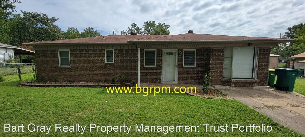
6 Compass Point St
North Little Rock, AR 72120
Favorites
6 Compass Point St

Favorites
Check Back Soon for Upcoming Availability
| Beds | Baths | Average SF |
|---|---|---|
| 3 Bedrooms 3 Bedrooms 3 Br | 1 Bath 1 Bath 1 Ba | 1,313 SF |
Fees and Policies
The fees listed below are community-provided and may exclude utilities or add-ons. All payments are made directly to the property and are non-refundable unless otherwise specified.
About This Property
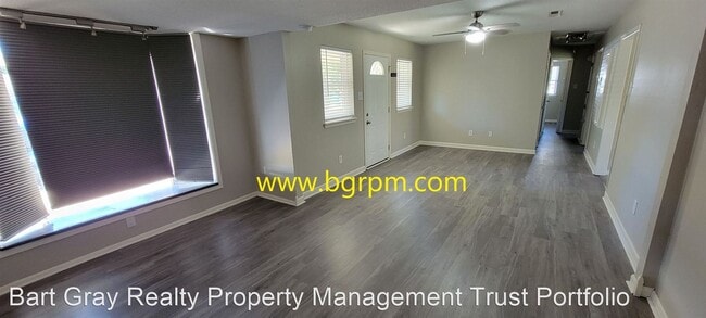
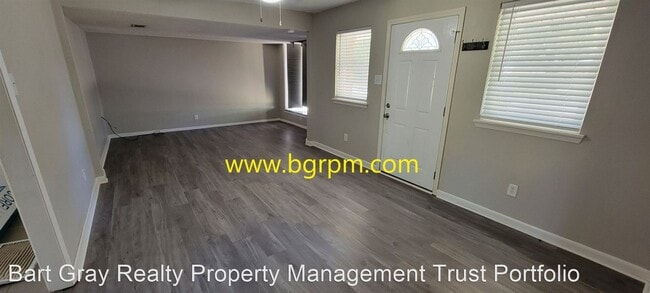
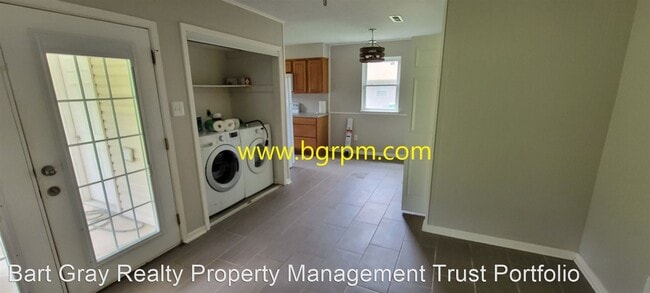
- 3 BD, 1 BA, Home in Sherwood - This 3 Bedroom, 1 Bath, home is located in the gravel ridge area a block from Sylvan Hills High School 9th & 10th grade. and Cato Elementary. This home features hard surface floors throughout, a covered back patio, large fenced yard, storage building. ****MOVE IN SPECIAL $250.00 OFF First Full Months Rent!!!! No Pets Allowed (RLNE7757795) Other Amenities: Other (pets per owner approval), Yard. Appliances: Dishwasher, Range, Microwave. Pet policies: No Dogs Allowed, No Cats Allowed.
6 Compass Point St is a house located in Pulaski County and the 72120 ZIP Code. This area is served by the Pulaski County Special School District attendance zone.
Unique Features
- No Dogs Allowed, No Cats Allowed, Amenities - pets per owner approval, Yard
House Features
- Dishwasher
6 Compass Point St,
North Little Rock,
AR
72120
Jacksonville/Sherwood is a wooded area about 15 miles north of Little Rock. The community’s northern and western regions are mostly rural, but the town has a lot to offer. Jacksonville/ Sherwood has a diverse rental market with an abundance of affordable rental options. Modern amenities are located within and right outside of town, giving residents plenty of shopping and dining choices at places like McCain Mall and Lakewood Village. Outdoor recreation is abundant with forested parks and trails as well as the ones surrounding the Arkansas River. Commuters will appreciate Interstate 40 and Highway 167, which make traveling a breeze.
Learn more about living in Jacksonville/SherwoodBelow are rent ranges for similar nearby apartments
Amenities
- Dishwasher
- No Dogs Allowed, No Cats Allowed, Amenities - pets per owner approval, Yard
Education
| Colleges & Universities | Distance | ||
|---|---|---|---|
| Colleges & Universities | Distance | ||
| Drive: | 27 min | 12.3 mi | |
| Drive: | 27 min | 15.2 mi | |
| Drive: | 30 min | 16.9 mi | |
| Drive: | 35 min | 20.0 mi |
6 Compass Point St is within 27 minutes or 12.3 miles from Pulaski Technical College. It is also near Philander Smith College and Univ. of Ark. Medical Scis..
Schools


Public Elementary School
Grades PK-5
266 Students
Attendance Zone
Public Middle School
Grades 6-8
764 Students
Attendance Zone
Public High School
Grades 9-12
1,061 Students
Attendance Zone
Private Elementary, Middle & High School
Grades PK-12
262 Students
Nearby
Private Elementary School
Grades PK-5
121 Students
Nearby
School data provided by
 The GreatSchools Rating helps parents compare schools within a state based on a variety of school quality indicators and provides a helpful picture of how effectively each school serves all of its students. Ratings are on a scale of 1 (below average) to 10 (above average) and can include test scores, college readiness, academic progress, advanced courses, equity, discipline and attendance data. We also advise parents to visit schools, consider other information on school performance and programs, and consider family needs as part of the school selection process.
View GreatSchools Rating Methodology
Data provided by GreatSchools.org © 2026. All rights reserved.
View GreatSchools Rating Methodology
Data provided by GreatSchools.org © 2026. All rights reserved.
Transportation options available in North Little Rock include Main St & Bishop Lindsey Ave, located 12.8 miles from 6 Compass Point St. 6 Compass Point St is near Bill and Hillary Clinton Ntl/Adams Field, located 18.1 miles or 31 minutes away.
| Transit / Subway | Distance | ||
|---|---|---|---|
| Transit / Subway | Distance | ||
| Drive: | 23 min | 12.8 mi | |
| Drive: | 23 min | 12.9 mi | |
| Drive: | 23 min | 13.1 mi | |
| Drive: | 23 min | 13.1 mi | |
| Drive: | 23 min | 13.1 mi |
| Commuter Rail | Distance | ||
|---|---|---|---|
| Commuter Rail | Distance | ||
|
|
Drive: | 26 min | 14.6 mi |
| Airports | Distance | ||
|---|---|---|---|
| Airports | Distance | ||
|
Bill and Hillary Clinton Ntl/Adams Field
|
Drive: | 31 min | 18.1 mi |
Walkability Near 6 Compass Point St North Little Rock, AR 72120
Getting Around
 What do Walkability, Transit, Drivability, and Bikeability mean?
Walkability measures the walking distance to day-to-day needs.
Transit measures access to public transportation.
Drivability measures congestion, parking availability, and access to major roads.
Bikeability measures the suitability for cycling.
How It Works
What do Walkability, Transit, Drivability, and Bikeability mean?
Walkability measures the walking distance to day-to-day needs.
Transit measures access to public transportation.
Drivability measures congestion, parking availability, and access to major roads.
Bikeability measures the suitability for cycling.
How It Works
Not Walkable
Walkability
10
/ 100
Minimal Public Transit
Transit
0
/ 100
Exceptionally Drivable
Drivability
90
/ 100
Somewhat Bikeable
Bikeability
20
/ 100
Scores provided by
-
Soundscore™
-
/ 100
Traffic
-Airport
-Businesses
-Scores provided by
HowLoud What is a Sound Score Rating? A Sound Score Rating aggregates noise caused by vehicle traffic, airplane traffic and local sources. How It WorksTime and distance from 6 Compass Point St.
| Shopping Centers | Distance | ||
|---|---|---|---|
| Shopping Centers | Distance | ||
| Drive: | 6 min | 2.3 mi | |
| Drive: | 6 min | 2.5 mi | |
| Drive: | 7 min | 2.7 mi |
6 Compass Point St has 3 shopping centers within 2.7 miles, which is about a 7-minute drive. The miles and minutes will be for the farthest away property.
| Parks and Recreation | Distance | ||
|---|---|---|---|
| Parks and Recreation | Distance | ||
|
Museum of Discovery
|
Drive: | 25 min | 13.9 mi |
|
Central Arkansas Nature Center
|
Drive: | 25 min | 13.9 mi |
|
Burns Park
|
Drive: | 26 min | 15.3 mi |
6 Compass Point St has 3 parks within 15.3 miles, including Burns Park, Museum of Discovery, and Central Arkansas Nature Center.
| Hospitals | Distance | ||
|---|---|---|---|
| Hospitals | Distance | ||
| Drive: | 15 min | 7.0 mi | |
| Drive: | 15 min | 7.2 mi | |
| Drive: | 19 min | 9.6 mi |
6 Compass Point St has 3 hospitals within 9.6 miles, the nearest is St. Vincent Medical Center North which is 7.0 miles away and a 15 minute drive.
| Military Bases | Distance | ||
|---|---|---|---|
| Military Bases | Distance | ||
| Drive: | 16 min | 7.2 mi | |
| Drive: | 38 min | 13.0 mi | |
| Drive: | 36 min | 14.3 mi |
6 Compass Point St has 3 military bases within 14.3 miles, the nearest is Little Rock Air Force Base which is 7.2 miles away and a 16 minute drive.
You May Also Like
Similar Rentals Nearby


What Are Walk Score®, Transit Score®, and Bike Score® Ratings?
Walk Score® measures the walkability of any address. Transit Score® measures access to public transit. Bike Score® measures the bikeability of any address.
What is a Sound Score Rating?
A Sound Score Rating aggregates noise caused by vehicle traffic, airplane traffic and local sources.

6 Compass Point St
North Little Rock, AR 72120