-
Adkins Ridge
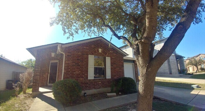
$1,300 / Month
6 Adkins Ridge
San Antonio, TX 78239
2 Weeks Ago
Favorites
6 Adkins Ridge

Favorites
Check Back Soon for Upcoming Availability
| Beds | Baths | Average SF |
|---|---|---|
| 2 Bedrooms 2 Bedrooms 2 Br | 2 Baths 2 Baths 2 Ba | 1,070 SF |
About This Property
Contact us to schedule a showing.
6 Adkins Ridge is a house located in Bexar County and the 78239 ZIP Code. This area is served by the North East Independent attendance zone.
Location
Get Directions
Northeast San Antonio, often called the Northeast Side, stretches along I-10 east past Randolph AFB. This terrific area provides residents with easy access to Downtown San Antonio as well as to nearby New Braunfels. Neighborhoods in the Northeast Side include Selma, Universal City, Converse, and Kirby.
Shoppers head to the Forum at Olympia Parkway, which contains shops like Target, Ross, and TJ Maxx. Pick up a few treats at la Madeleine French Bakery & Café or have dinner at Nicha’s Cocina Mexicana. This shopping area also contains the Regal Live Oak & RPX movie theater and the Universal City Dog Park. Commuters have easy access to I-410 and I-35, allowing them to reach Downtown San Antonio in less than 20 minutes.
Learn more about living in Northeast San AntonioBelow are rent ranges for similar nearby apartments
Education
| Colleges & Universities | Distance | ||
|---|---|---|---|
| Colleges & Universities | Distance | ||
| Drive: | 11 min | 6.0 mi | |
| Drive: | 17 min | 7.9 mi | |
| Drive: | 18 min | 9.2 mi | |
| Drive: | 17 min | 10.3 mi |
6 Adkins Ridge is within 11 minutes or 6.0 miles from Northeast Lakeview College. It is also near Univ. of the Incarnate Word and Trinity University.
Schools


Public Elementary School
Grades PK-5
491 Students
Attendance Zone
Public Middle School
Grades 6-8
944 Students
Attendance Zone
Public High School
Grades 9-12
2,599 Students
Attendance Zone
Private Elementary, Middle & High School
Grades PK-12
897 Students
Nearby
School data provided by
 The GreatSchools Rating helps parents compare schools within a state based on a variety of school quality indicators and provides a helpful picture of how effectively each school serves all of its students. Ratings are on a scale of 1 (below average) to 10 (above average) and can include test scores, college readiness, academic progress, advanced courses, equity, discipline and attendance data. We also advise parents to visit schools, consider other information on school performance and programs, and consider family needs as part of the school selection process.
View GreatSchools Rating Methodology
Data provided by GreatSchools.org © 2025. All rights reserved.
View GreatSchools Rating Methodology
Data provided by GreatSchools.org © 2025. All rights reserved.
You May Also Like
Similar Rentals Nearby
-
-
1 / 14

-
-
-
-
-
-
-
-
1 / 50


What Are Walk Score®, Transit Score®, and Bike Score® Ratings?
Walk Score® measures the walkability of any address. Transit Score® measures access to public transit. Bike Score® measures the bikeability of any address.
What is a Sound Score Rating?
A Sound Score Rating aggregates noise caused by vehicle traffic, airplane traffic and local sources

6 Adkins Ridge
San Antonio, TX 78239