
$2,395
/ Month
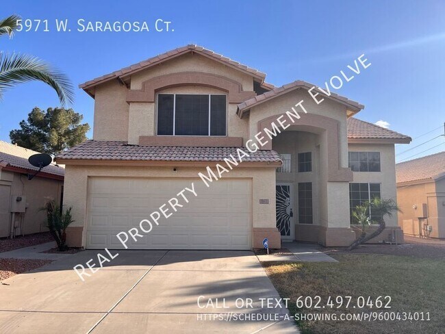
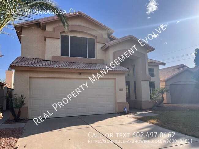
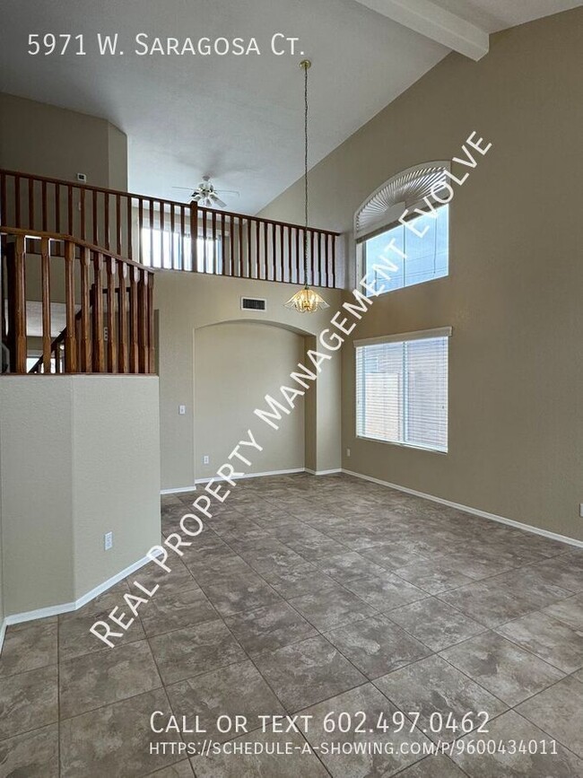
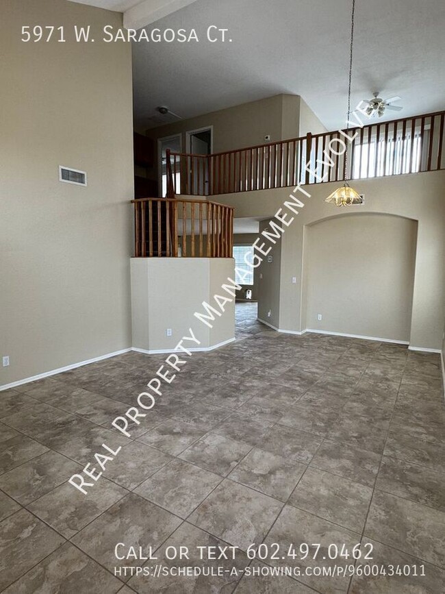
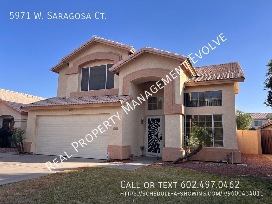
5971 W Saragosa Ct
Chandler, AZ 85226
Favorites
-
Bedrooms
3
-
Bathrooms
2.5
-
Square Feet
1,928 sq ft
5971 W Saragosa Ct

Favorites
About This Home
---- SCHEDULE A SHOWING ONLINE AT: ---- This 3-bed, 2.5-bath home near Kyrene and the 202 South in Chandler is nestled at the end of a quiet cul-de-sac. Upgraded tile, separate formal living room, family room with gas fireplace, eat-in kitchen, and laundry room with washer and dryer included. Upstairs loft area with outdoor balcony. Large primary suite with dual-sink vanity, large walk-in shower, and walk-in closet. Backyard is well-manicured with a swimming pool and covered patio. Garage includes storage cabinets. Walking distance from West Chandler Park. This home will not last long! *Pool maintenance included in the rent! *Pets not accepted. Schedule a self-guided tour today at
5971 W Saragosa Ct is a house located in Maricopa County and the 85226 ZIP Code. This area is served by the Kyrene Elementary School District attendance zone.
* Price shown is base rent. Excludes user-selected optional fees and variable or usage-based fees and required charges due at or prior to move-in or at move-out. Price, availability, fees, and any applicable rent special are subject to change without notice.
* Square footage definitions vary. Displayed square footage is approximate.
House Features
Air Conditioning
Dishwasher
Microwave
Refrigerator
- Air Conditioning
- Fireplace
- Dishwasher
- Microwave
- Refrigerator
Fees and Policies
The fees listed below are community-provided and may exclude utilities or add-ons. All payments are made directly to the property and are non-refundable unless otherwise specified.
- Parking
-
Garage--
-
Other--
Contact
- Listed by Leasing Agent
Location
Get Directions
Situated about four miles west of Downtown Chandler, West Chandler is a scenic suburb brimming with recreation and retail. West Chandler residents enjoy access to an array of local parks, including Desert Breeze Park, Nozomi Park, and Hanger Park, as well as close proximity to the sprawling South Mountain Park.
Retail options in West Chandler provide a host of modern delights and everyday conveniences, with numerous shopping centers and plazas strewn throughout the area in addition to the upscale Chandler Fashion Center. West Chandler is also convenient to the popular Lone Butte Casino. Getting around from West Chandler is easy with access to the Santan Freeway, Maricopa Freeway, and the Price Freeway.
Learn more about living in West Chandler
Amenities
- Air Conditioning
- Fireplace
- Dishwasher
- Microwave
- Refrigerator
Education
| Colleges & Universities | Distance | ||
|---|---|---|---|
| Colleges & Universities | Distance | ||
| Drive: | 17 min | 10.5 mi | |
| Drive: | 17 min | 11.3 mi | |
| Drive: | 20 min | 11.7 mi | |
| Drive: | 18 min | 12.3 mi |
5971 W Saragosa Ct is within 17 minutes or 10.5 miles from Chandler-Gilbert CC. Sun Lakes. It is also near Mesa C.C., Southern and Dobson and South Mountain Comm. Coll..
Schools


Public Elementary & Middle School
Grades K-8
565 Students
Attendance Zone
Public Elementary School
Grades PK-5
434 Students
Attendance Zone
Public High School
Grades 9-12
1,564 Students
Attendance Zone
Private Elementary & Middle School
Grades PK-8
357 Students
Nearby
Private Middle & High School
Grades 6-12
Nearby
School data provided by
 The GreatSchools Rating helps parents compare schools within a state based on a variety of school quality indicators and provides a helpful picture of how effectively each school serves all of its students. Ratings are on a scale of 1 (below average) to 10 (above average) and can include test scores, college readiness, academic progress, advanced courses, equity, discipline and attendance data. We also advise parents to visit schools, consider other information on school performance and programs, and consider family needs as part of the school selection process.
View GreatSchools Rating Methodology
Data provided by GreatSchools.org © 2026. All rights reserved.
View GreatSchools Rating Methodology
Data provided by GreatSchools.org © 2026. All rights reserved.
Transportation options available in Chandler include Eleventh St/Mill, located 8.9 miles from 5971 W Saragosa Ct. 5971 W Saragosa Ct is near Phoenix Sky Harbor International, located 14.0 miles or 21 minutes away, and Phoenix-Mesa Gateway, located 17.8 miles or 26 minutes away.
| Transit / Subway | Distance | ||
|---|---|---|---|
| Transit / Subway | Distance | ||
|
|
Drive: | 17 min | 8.9 mi |
|
|
Drive: | 17 min | 9.0 mi |
|
|
Drive: | 18 min | 9.3 mi |
|
|
Drive: | 18 min | 9.5 mi |
|
|
Drive: | 19 min | 13.4 mi |
| Commuter Rail | Distance | ||
|---|---|---|---|
| Commuter Rail | Distance | ||
|
|
Drive: | 27 min | 19.7 mi |
| Airports | Distance | ||
|---|---|---|---|
| Airports | Distance | ||
|
Phoenix Sky Harbor International
|
Drive: | 21 min | 14.0 mi |
|
Phoenix-Mesa Gateway
|
Drive: | 26 min | 17.8 mi |
Getting Around
 What do Walkability, Transit, Drivability, and Bikeability mean?
Walkability measures the walking distance to day-to-day needs.
Transit measures access to public transportation.
Drivability measures congestion, parking availability, and access to major roads.
Bikeability measures the suitability for cycling.
How It Works
What do Walkability, Transit, Drivability, and Bikeability mean?
Walkability measures the walking distance to day-to-day needs.
Transit measures access to public transportation.
Drivability measures congestion, parking availability, and access to major roads.
Bikeability measures the suitability for cycling.
How It Works
Fairly Walkable
Walkability
40
/ 100
Limited Public Transit
Transit
30
/ 100
Exceptionally Drivable
Drivability
100
/ 100
Fairly Bikeable
Bikeability
50
/ 100
Scores provided by
-
Soundscore™
-
/ 100
Traffic
-Airport
-Businesses
-Scores provided by
HowLoud What is a Sound Score Rating? A Sound Score Rating aggregates noise caused by vehicle traffic, airplane traffic and local sources. How It WorksTime and distance from 5971 W Saragosa Ct.
| Shopping Centers | Distance | ||
|---|---|---|---|
| Shopping Centers | Distance | ||
| Walk: | 13 min | 0.7 mi | |
| Walk: | 14 min | 0.8 mi | |
| Walk: | 15 min | 0.8 mi |
5971 W Saragosa Ct has 3 shopping centers within 0.8 mile, which is about a 15-minute walk. The miles and minutes will be for the farthest away property.
| Parks and Recreation | Distance | ||
|---|---|---|---|
| Parks and Recreation | Distance | ||
|
Pecos Park
|
Drive: | 8 min | 3.7 mi |
|
South Mountain Park
|
Drive: | 15 min | 7.7 mi |
|
ASU Center for Meteorite Studies
|
Drive: | 20 min | 9.7 mi |
|
Desert Arboretum Park
|
Drive: | 21 min | 10.5 mi |
|
Camelback Mountain Park
|
Drive: | 28 min | 15.7 mi |
5971 W Saragosa Ct has 5 parks within 15.7 miles, including Pecos Park, South Mountain Park, and ASU Center for Meteorite Studies.
| Hospitals | Distance | ||
|---|---|---|---|
| Hospitals | Distance | ||
| Drive: | 9 min | 5.2 mi | |
| Drive: | 10 min | 5.2 mi | |
| Drive: | 9 min | 6.4 mi |
5971 W Saragosa Ct has 3 hospitals within 6.4 miles, the nearest is Chandler Regional Medical Center which is 5.2 miles away and a 9 minute drive.
| Military Bases | Distance | ||
|---|---|---|---|
| Military Bases | Distance | ||
| Drive: | 21 min | 14.8 mi | |
| Drive: | 50 min | 39.0 mi | |
| Drive: | 96 min | 78.5 mi |
5971 W Saragosa Ct has 3 military bases within 78.5 miles, the nearest is Phoenix Sky Harbor Airport Air Guard Station which is 14.8 miles away and a 21 minute drive.
You May Also Like
-
Rev3 at Avondale Station | Homes for Rent
9980 W Encanto Blvd
Avondale, AZ 85392
$2,996 - $3,096 Total Monthly Price
3 Br 22.7 mi
-
Village at Olive Marketplace
5201 W Olive Ave
Glendale, AZ 85302
$2,700 - $2,800
3 Br 22.8 mi
-
Avilla Western Garden
4041 N 97th Ave
Phoenix, AZ 85037
$2,093 - $2,982
3 Br 23.2 mi
Similar Rentals Nearby
-
-
-
1 / 73
 3 Beds$2,582+Total Monthly PriceTotal Monthly Price NewPrices include base rent and required monthly fees of $71. Variable costs based on usage may apply.Base Rent:3 Beds$2,510+2 Months Free
Pets Allowed Fitness Center Pool Dishwasher Refrigerator Kitchen
-
-
-
-
-
3 Beds$2,209+Total Monthly PriceTotal Monthly Price NewPrices include base rent and required monthly fees of $264. Variable costs based on usage may apply.Base Rent:3 Beds$1,944+2 Months Free
Pets Allowed Fitness Center Pool Dishwasher Walk-In Closets Stainless Steel Appliances
-
-


What Are Walk Score®, Transit Score®, and Bike Score® Ratings?
Walk Score® measures the walkability of any address. Transit Score® measures access to public transit. Bike Score® measures the bikeability of any address.
What is a Sound Score Rating?
A Sound Score Rating aggregates noise caused by vehicle traffic, airplane traffic and local sources.
5971 W Saragosa Ct
Chandler, AZ 85226