$2,100
/ Month
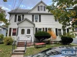
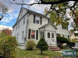
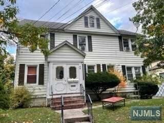
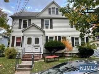
59 Robinson St
Teaneck, NJ 07666
Favorites
59 Robinson St

Favorites
Check Back Soon for Upcoming Availability
| Beds | Baths | Average SF |
|---|---|---|
| 3 Bedrooms 3 Bedrooms 3 Br | 1 Bath 1 Bath 1 Ba | — |
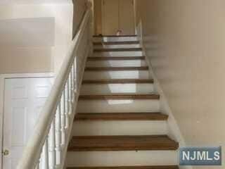
About This Property
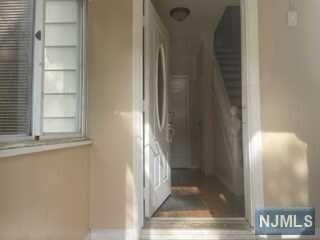
Updated three bedrooms apartment on 2nd and 3rd floors of Multi-family building, conveniently located to shopping, public transportation, highways and schools. Newer appliances. Landlord require credit report, interview and proof of income. Tenant responsible for 50% of second floor utilities.
59 Robinson St is an apartment community located in Bergen County and the 07666 ZIP Code.
59 Robinson St,
Teaneck,
NJ
07666
Residents are elated to live in the suburban paradise that is West Englewood. Situated in Teaneck New Jersey, this neighborhood offers a family-friendly vibe and is close to topnotch public schools like Teaneck High School. With the Teaneck Sportsplex and Milton A. Votee Park, residents of all ages can enjoy some fun recreation without having to leave the neighborhood.
Enjoy a live concert at Debonair Music Hall, or dine at one of West Englewood’s locally-owned restaurants. East of Fairleigh Dickinson University, this neighborhood has somewhat of a college town feel, and it’s a major hub for commuters. West Englewood is just a few miles off of the Hudson River, providing quick commutes for residents into Manhattan.
Learn more about living in West EnglewoodBelow are rent ranges for similar nearby apartments
Education
| Colleges & Universities | Distance | ||
|---|---|---|---|
| Colleges & Universities | Distance | ||
| Drive: | 5 min | 3.0 mi | |
| Drive: | 5 min | 3.2 mi | |
| Drive: | 10 min | 6.4 mi | |
| Drive: | 14 min | 8.4 mi |
59 Robinson St is within 5 minutes or 3.2 miles from Fairleigh Dickinson, Metro. It is also near Bergen C.C., Ciarco Center and Yeshiva University, Wilf.
Transportation options available in Teaneck include 181 Street (A Line), located 5.8 miles from 59 Robinson St. 59 Robinson St is near LaGuardia, located 15.3 miles or 26 minutes away, and Newark Liberty International, located 17.9 miles or 21 minutes away.
| Transit / Subway | Distance | ||
|---|---|---|---|
| Transit / Subway | Distance | ||
|
|
Drive: | 8 min | 5.8 mi |
|
|
Drive: | 9 min | 6.0 mi |
|
|
Drive: | 11 min | 6.4 mi |
|
|
Drive: | 11 min | 7.1 mi |
|
|
Drive: | 11 min | 7.5 mi |
| Commuter Rail | Distance | ||
|---|---|---|---|
| Commuter Rail | Distance | ||
|
|
Drive: | 4 min | 2.8 mi |
|
|
Drive: | 6 min | 3.0 mi |
|
|
Drive: | 8 min | 4.2 mi |
|
|
Drive: | 6 min | 4.6 mi |
|
|
Drive: | 9 min | 5.9 mi |
| Airports | Distance | ||
|---|---|---|---|
| Airports | Distance | ||
|
LaGuardia
|
Drive: | 26 min | 15.3 mi |
|
Newark Liberty International
|
Drive: | 21 min | 17.9 mi |
Walkability Near 59 Robinson St Teaneck, NJ 07666
Getting Around
 What do Walkability, Transit, Drivability, and Bikeability mean?
Walkability measures the walking distance to day-to-day needs.
Transit measures access to public transportation.
Drivability measures congestion, parking availability, and access to major roads.
Bikeability measures the suitability for cycling.
How It Works
What do Walkability, Transit, Drivability, and Bikeability mean?
Walkability measures the walking distance to day-to-day needs.
Transit measures access to public transportation.
Drivability measures congestion, parking availability, and access to major roads.
Bikeability measures the suitability for cycling.
How It Works
Moderately Walkable
Walkability
70
/ 100
Some Public Transit
Transit
50
/ 100
Moderately Drivable
Drivability
70
/ 100
Fairly Bikeable
Bikeability
50
/ 100
Scores provided by
-
Soundscore™
-
/ 100
Traffic
-Airport
-Businesses
-Scores provided by
HowLoud What is a Sound Score Rating? A Sound Score Rating aggregates noise caused by vehicle traffic, airplane traffic and local sources. How It WorksTime and distance from 59 Robinson St.
| Shopping Centers | Distance | ||
|---|---|---|---|
| Shopping Centers | Distance | ||
| Walk: | 13 min | 0.7 mi |
59 Robinson St has 1 shopping centers within 0.7 mile, which is about a 13-minute walk. The miles and minutes will be for the farthest away property.
| Parks and Recreation | Distance | ||
|---|---|---|---|
| Parks and Recreation | Distance | ||
|
Teaneck Creek Conservancy
|
Drive: | 3 min | 1.7 mi |
|
Flat Rock Brook Nature Center
|
Drive: | 5 min | 3.3 mi |
|
Overpeck County Park
|
Drive: | 7 min | 3.7 mi |
|
Van Saun County Park
|
Drive: | 7 min | 5.0 mi |
|
Tenafly Nature Center
|
Drive: | 11 min | 7.1 mi |
59 Robinson St has 5 parks within 7.1 miles, including Teaneck Creek Conservancy, Flat Rock Brook Nature Center, and Overpeck County Park.
| Hospitals | Distance | ||
|---|---|---|---|
| Hospitals | Distance | ||
| Walk: | 16 min | 0.9 mi | |
| Drive: | 6 min | 2.7 mi | |
| Drive: | 8 min | 4.7 mi |
59 Robinson St has 3 hospitals within 4.7 miles, the nearest is Holy Name Medical Center which is 0.9 mile away and a 16 minute walk.
| Military Bases | Distance | ||
|---|---|---|---|
| Military Bases | Distance | ||
| Drive: | 27 min | 16.9 mi | |
| Drive: | 31 min | 18.8 mi | |
| Drive: | 29 min | 22.2 mi |
59 Robinson St has 3 military bases within 22.2 miles, the nearest is Fort Totten US Govt Reservation which is 16.9 miles away and a 27 minute drive.
You May Also Like
How do I access Social Services in New Jersey?
Statewide service is free, confidential, multilingual and always open. Three easy ways to reach Social Services in NJ: Dial 2-1-1; text your zip code to 898-211; or chat at https://www.nj211.org
Similar Rentals Nearby
-
-
-
-
1 / 15
 3 Beds$7,027+Total Monthly PriceTotal Monthly Price NewPrices include base rent and required monthly fees of $94. Variable costs based on usage may apply.Base Rent:3 Beds$6,932+2 Months Free
Pets Allowed Fitness Center Pool In Unit Washer & Dryer Stainless Steel Appliances
-
-
-
-
-
-


What Are Walk Score®, Transit Score®, and Bike Score® Ratings?
Walk Score® measures the walkability of any address. Transit Score® measures access to public transit. Bike Score® measures the bikeability of any address.
What is a Sound Score Rating?
A Sound Score Rating aggregates noise caused by vehicle traffic, airplane traffic and local sources.
59 Robinson St
Teaneck, NJ 07666