
$1,600
/ Month
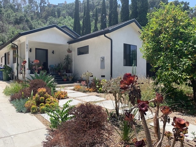
582 Pullman St
Los Angeles, CA 90042
2 Weeks Ago
|
Edit
Favorites
582 Pullman St

Favorites
Check Back Soon for Upcoming Availability
| Beds | Baths | Average SF |
|---|---|---|
| 1 Bedroom 1 Bedroom 1 Br | 1 Bath 1 Bath 1 Ba | 1,300 SF |
Fees and Policies
The fees below are based on community-supplied data and may exclude additional fees and utilities.
Details
Utilities Included
-
Water
-
Sewer
Property Information
-
Furnished Units Available
About This Property
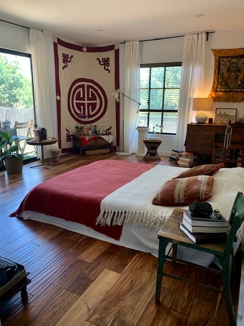
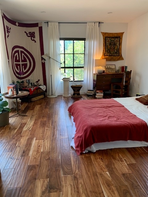
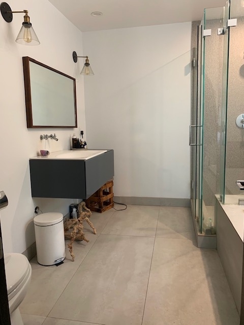
Property Id: 231249 A Private Primary Bed & Bath (400 SQFT) for rent in a 3 Bed / 2 Bath home for a 12-mo/yr lease starting on 7/1/25. This is a rental of 1 bed/bath, not the whole house - shared living space. Nestled in a quiet cul-de-sac street, this home immersed in nature has an open floor plan and vaulted ceilings/skylights bringing natural daylight. The property is fenced with monthly garden maintenance included. Nature lovers can jog to Hermon Arroyo Seco and Debs Park for hikes & recreation. Easy access to the 110FWY with local organic market Fresco within walking distance. House is shared w/ a dog and a guy & girl in their 30s - both are creative professionals. Looking for a considerate and clean roommate who also likes the idea of contributing to a shared home vs just being neighbors. Feel free to get to know us more @abwyman @jacklewisstudio Rent & Sec = $1,600/mo. + Utilities 1 year lease Application fee for credit & background check per turbo tenant
582 Pullman St is a house located in Los Angeles County and the 90042 ZIP Code. This area is served by the Los Angeles Unified attendance zone.
House Features
Washer/Dryer
Dishwasher
Hardwood Floors
Microwave
- Washer/Dryer
- Dishwasher
- Disposal
- Microwave
- Oven
- Refrigerator
- Freezer
- Hardwood Floors
- Vaulted Ceiling
- Furnished
- Fenced Lot
Location
Get Directions
A quiet suburb outside of Los Angeles, Monterey Hills is known for its rolling hills, winding residential streets, and elevated city views. Check out Elephant Hill, a popular place to bike or hike that offers beautiful views of the neighborhood. Herman Park is nestled along Highway 110 in the north end of the neighborhood, offering tennis courts, playgrounds, and a dog park. And for more outdoor recreation, visit the biking paths and hiking trails at Ernest E. Debs Regional Park, bordering Monterey Hills.
Monterey Hills is a more secluded part of Northeast Los Angeles with larger lots, single-family homes, and tree-lined streets. However, if you cross over Highway 110, you’ll find theatres, restaurants, services, and more. Monterey Hills is located just seven miles northeast of Downtown Los Angeles and eight miles east of major attractions such as Griffith Park, the Los Angeles Zoo, the Greek Theatre, and Glendale Galleria.
Learn more about living in Monterey HillsBelow are rent ranges for similar nearby apartments
| Beds | Average Size | Lowest | Typical | Premium |
|---|---|---|---|---|
| Studio Studio Studio | 440 Sq Ft | $1,739 | $2,044 | $2,349 |
| 1 Bed 1 Bed 1 Bed | 628 Sq Ft | $1,700 | $2,222 | $2,849 |
| 2 Beds 2 Beds 2 Beds | 998-1007 Sq Ft | $1,647 | $3,058 | $5,184 |
| 3 Beds 3 Beds 3 Beds | 1234 Sq Ft | $1,901 | $3,745 | $7,900 |
| 4 Beds 4 Beds 4 Beds | 1665 Sq Ft | $1,060 | $3,769 | $8,000 |
Amenities
- Washer/Dryer
- Dishwasher
- Disposal
- Microwave
- Oven
- Refrigerator
- Freezer
- Hardwood Floors
- Vaulted Ceiling
- Furnished
- Fenced Lot
Expenses
Utilities Included
Water, Sewer
Included
Education
| Colleges & Universities | Distance | ||
|---|---|---|---|
| Colleges & Universities | Distance | ||
| Drive: | 9 min | 3.6 mi | |
| Drive: | 9 min | 3.9 mi | |
| Drive: | 7 min | 3.9 mi | |
| Drive: | 12 min | 4.9 mi |
582 Pullman St is within 9 minutes or 3.6 miles from Occidental College. It is also near Art Center College of Design and USC, Health Sciences Campus.
Schools


Charter Elementary School
Grades K-5
75 Students
Nearby
Public Elementary School
Grades K-5
181 Students
Attendance Zone
Public Middle School
Grades 6-8
904 Students
Attendance Zone
Public Middle & High School
Grades 6-12
1,389 Students
Attendance Zone
Private Elementary School
Grades PK-5
131 Students
Nearby
Private Elementary, Middle & High School
Grades K-12
Nearby
Private Elementary & Middle School
Grades K-8
Nearby
School data provided by
 The GreatSchools Rating helps parents compare schools within a state based on a variety of school quality indicators and provides a helpful picture of how effectively each school serves all of its students. Ratings are on a scale of 1 (below average) to 10 (above average) and can include test scores, college readiness, academic progress, advanced courses, equity, discipline and attendance data. We also advise parents to visit schools, consider other information on school performance and programs, and consider family needs as part of the school selection process.
View GreatSchools Rating Methodology
Data provided by GreatSchools.org © 2025. All rights reserved.
View GreatSchools Rating Methodology
Data provided by GreatSchools.org © 2025. All rights reserved.
Transportation options available in Los Angeles include Highland Park Station, located 1.4 miles from 582 Pullman St. 582 Pullman St is near Bob Hope, located 17.8 miles or 26 minutes away, and Los Angeles International, located 20.9 miles or 34 minutes away.
| Transit / Subway | Distance | ||
|---|---|---|---|
| Transit / Subway | Distance | ||
|
|
Drive: | 4 min | 1.4 mi |
|
|
Drive: | 6 min | 2.6 mi |
|
|
Drive: | 7 min | 2.8 mi |
|
|
Drive: | 6 min | 2.9 mi |
|
|
Drive: | 7 min | 3.6 mi |
| Commuter Rail | Distance | ||
|---|---|---|---|
| Commuter Rail | Distance | ||
|
|
Drive: | 11 min | 5.8 mi |
|
|
Drive: | 13 min | 5.8 mi |
|
|
Drive: | 12 min | 7.1 mi |
| Drive: | 15 min | 9.9 mi | |
|
|
Drive: | 22 min | 10.9 mi |
| Airports | Distance | ||
|---|---|---|---|
| Airports | Distance | ||
|
Bob Hope
|
Drive: | 26 min | 17.8 mi |
|
Los Angeles International
|
Drive: | 34 min | 20.9 mi |
Time and distance from 582 Pullman St.
| Shopping Centers | Distance | ||
|---|---|---|---|
| Shopping Centers | Distance | ||
| Drive: | 3 min | 1.2 mi | |
| Drive: | 4 min | 1.7 mi | |
| Drive: | 5 min | 1.7 mi |
582 Pullman St has 3 shopping centers within 1.7 miles, which is about a 5-minute drive. The miles and minutes will be for the farthest away property.
| Parks and Recreation | Distance | ||
|---|---|---|---|
| Parks and Recreation | Distance | ||
|
Audubon Center at Debs Park
|
Drive: | 5 min | 1.8 mi |
|
Chavez Ravine Arboretum
|
Drive: | 10 min | 5.5 mi |
|
Elysian Park
|
Drive: | 13 min | 5.6 mi |
|
Elyria Canyon Park
|
Drive: | 12 min | 5.8 mi |
|
Marsh Park
|
Drive: | 12 min | 6.1 mi |
582 Pullman St has 5 parks within 6.1 miles, including Audubon Center at Debs Park, Elyria Canyon Park, and Elysian Park.
| Hospitals | Distance | ||
|---|---|---|---|
| Hospitals | Distance | ||
| Drive: | 8 min | 3.6 mi | |
| Drive: | 9 min | 4.2 mi | |
| Drive: | 7 min | 4.4 mi |
582 Pullman St has 3 hospitals within 4.4 miles, the nearest is Keck Hospital of USC which is 3.6 miles away and a 8 minute drive.
| Military Bases | Distance | ||
|---|---|---|---|
| Military Bases | Distance | ||
| Drive: | 31 min | 22.4 mi | |
| Drive: | 43 min | 28.6 mi |
582 Pullman St is 22.4 miles from Los Angeles Air Force Base, and is convenient to other military bases, including Los Alamitos Army Airfield.
You May Also Like
Similar Rentals Nearby


What Are Walk Score®, Transit Score®, and Bike Score® Ratings?
Walk Score® measures the walkability of any address. Transit Score® measures access to public transit. Bike Score® measures the bikeability of any address.
What is a Sound Score Rating?
A Sound Score Rating aggregates noise caused by vehicle traffic, airplane traffic and local sources

582 Pullman St
Los Angeles, CA 90042